San Agustin, Surigao del Sur
| San Agustin | |
|---|---|
| Municipality | |
| Municipality of San Agustin | |
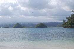 Britania Islets at the Lianga Bay in San Agustin | |
| Nickname(s): Heart of Surigao del Sur | |
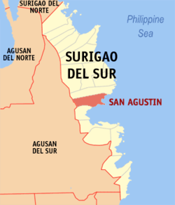 Map of Surigao del Sur with San Agustin highlighted | |
.svg.png) San Agustin Location within the Philippines | |
| Coordinates: 8°44′N 126°08′E / 8.73°N 126.13°ECoordinates: 8°44′N 126°08′E / 8.73°N 126.13°E | |
| Country |
|
| Region | Caraga (Region XIII) |
| Province | Surigao del Sur |
| District | 1st District |
| Barangays | 13 (see Barangays) |
| Government [1] | |
| • Type | Sangguniang Bayan |
| • Mayor | Libertad Osorio Alameda |
| • Electorate | 11,351 voters (2016) |
| Area [2] | |
| • Total | 277.28 km2 (107.06 sq mi) |
| Population (2015 census)[3] | |
| • Total | 22,779 |
| • Density | 82/km2 (210/sq mi) |
| Time zone | UTC+8 (PST) |
| ZIP code | 8305 |
| PSGC | 166815000 |
| IDD : area code | +63 (0)86 |
| Climate type | Tropical rainforest climate |
| Income class | 4th municipal income class |
| Revenue (₱) | 93,840,535.16 (2016) |
| Native languages |
Surigaonon Agusan language Cebuano Kamayo Tagalog |
| Website |
www |
San Agustin, officially the Municipality of San Agustin, is a 4th class municipality in the province of Surigao del Sur, Philippines. According to the 2015 census, it has a population of 22,779 people.[3]
The town is famous for the Britania Group of Islands (or simply Britania Islets), a group of 24 islands with white sandbar beaches scattered across waters of the Lianga Bay, overlooking the Philippine Sea.
Barangays
San Agustin is politically subdivided into 13 barangays.
- Britania
- Buatong
- Buhisan
- Gata
- Hornasan
- Janipaan
- Kauswagan
- Oteiza
- Poblacion
- Pong-on
- Pongtod
- Salvacion
- Sto. Niño
Demographics
| Population census of San Agustin | ||
|---|---|---|
| Year | Pop. | ±% p.a. |
| 1970 | 7,100 | — |
| 1975 | 9,309 | +5.58% |
| 1980 | 10,024 | +1.49% |
| 1990 | 11,982 | +1.80% |
| 1995 | 13,768 | +2.64% |
| 2000 | 14,845 | +1.63% |
| 2007 | 19,546 | +3.87% |
| 2010 | 20,655 | +2.03% |
| 2015 | 22,779 | +1.88% |
| Source: Philippine Statistics Authority[3][4][5][6] | ||
References
- ↑ "Municipality". Quezon City, Philippines: Department of the Interior and Local Government. Retrieved 31 May 2013.
- ↑ "Province: Surigao del Sur". PSGC Interactive. Quezon City, Philippines: Philippine Statistics Authority. Retrieved 12 November 2016.
- 1 2 3 Census of Population (2015). "Caraga". Total Population by Province, City, Municipality and Barangay. PSA. Retrieved 20 June 2016.
- ↑ Census of Population and Housing (2010). "Caraga". Total Population by Province, City, Municipality and Barangay. NSO. Retrieved 29 June 2016.
- ↑ Censuses of Population (1903–2007). "Caraga". Table 1. Population Enumerated in Various Censuses by Province/Highly Urbanized City: 1903 to 2007. NSO.
- ↑ "Province of Surigao del Sur". Municipality Population Data. Local Water Utilities Administration Research Division. Retrieved 17 December 2016.
External links
- Philippine Standard Geographic Code
- Philippine Census Information
- Local Governance Performance Management System
- Ka Webspy's Blog on San Agustin or Oteiza
Places adjacent to San Agustin, Surigao del Sur | ||||||||||
|---|---|---|---|---|---|---|---|---|---|---|
| ||||||||||
Tandag (capital) | |
| Municipalities | |
| Component cities | |
This article is issued from
Wikipedia.
The text is licensed under Creative Commons - Attribution - Sharealike.
Additional terms may apply for the media files.