Mainit, Surigao del Norte
| Mainit | ||
|---|---|---|
| Municipality | ||
| Municipality of Mainit | ||
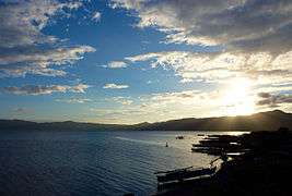 Sunset over Lake Mainit | ||
| ||
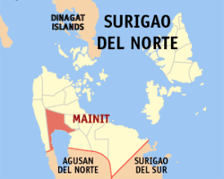 Map of Surigao del Norte with Mainit highlighted | ||
.svg.png) Mainit Location within the Philippines | ||
| Coordinates: 9°32′06″N 125°31′23″E / 9.535°N 125.52306°ECoordinates: 9°32′06″N 125°31′23″E / 9.535°N 125.52306°E | ||
| Country |
| |
| Region | Caraga (Region XIII) | |
| Province | Surigao del Norte | |
| District | 2nd District | |
| Founded | December 27, 1930 | |
| Barangays | 21 (see Barangays) | |
| Government [1] | ||
| • Type | Sangguniang Bayan | |
| • Mayor | Crisanta Olvis Mondano, Ed.D | |
| • Vice Mayor | Ramon Beltran Mondano | |
| • Electorate | 18,154 voters (2016) | |
| Area [2] | ||
| • Total | 107.76 km2 (41.61 sq mi) | |
| Population (2015 census)[3] | ||
| • Total | 26,741 | |
| • Density | 250/km2 (640/sq mi) | |
| Time zone | UTC+8 (PST) | |
| ZIP code | 8417 | |
| PSGC | 166714000 | |
| IDD : area code | +63 (0)86 | |
| Climate type | Tropical rainforest climate | |
| Income class | 4th municipal income class | |
| Revenue (₱) | 102,486,325.51 (2016) | |
| Native languages |
Surigaonon Agusan language Cebuano Mamanwa Tagalog | |
| Website |
www | |

Mainit, officially the Municipality of Mainit, is a 4th class municipality in the province of Surigao del Norte, Philippines. According to the 2015 census, it has a population of 26,741 people.[3]
It is situated on the north shore of Lake Mainit in the north-eastern part of Mindanao. The word "mainit" literally means "hot".
Barangays
Mainit is politically subdivided into 21 barangays. In 1956, the sitios of Magpayang and Siana were elevated as barrios.[4]
History
The first inhabitants of Mainit settled near Lake Mainit in what is now barangay San Isidro. It was believed that the constant harassment of pirates forced the original settlers to move to the present town site.
Mainit was made into a barrio in 1904 under the Municipality of Placer. In 1906, it became a Municipality of Agusan Province but after six months, Mainit was returned to the Province of Surigao del Norte and its status was reverted to being a barangay of Placer. Mainit was finally made into a municipality in Jan. 1, 1931 by virtue of Executive Order 290 dated December 27, 1930,[5] signed by Governor-General Dwight F. Davis.
Two of Mainit’s barangays were made into full-fledged municipalities: Tubod in 1958 and Alegria in 1968. and Mainit the mainit has many Barangays Magsaysay, Quezon,Mansayao and others
Mainit got its name from the hot sulfuric spring which flows to the river the “Mapaso Hot Spring”. Mapaso literally is “hot”.[6]
Demographics
| Population census of Mainit | ||||||||||||||||||||||||||||||||||||||||||||||
|---|---|---|---|---|---|---|---|---|---|---|---|---|---|---|---|---|---|---|---|---|---|---|---|---|---|---|---|---|---|---|---|---|---|---|---|---|---|---|---|---|---|---|---|---|---|---|
|
| |||||||||||||||||||||||||||||||||||||||||||||
| Source: Philippine Statistics Authority[3][7][8][9] | ||||||||||||||||||||||||||||||||||||||||||||||
The Surigaonon language is the common local language, while Cebuano, Filipino, and English are also spoken.
See also
References
- ↑ "Municipality". Quezon City, Philippines: Department of the Interior and Local Government. Retrieved 31 May 2013.
- ↑ "Province: Surigao del Norte". PSGC Interactive. Quezon City, Philippines: Philippine Statistics Authority. Retrieved 12 November 2016.
- 1 2 3 Census of Population (2015). "Caraga". Total Population by Province, City, Municipality and Barangay. PSA. Retrieved 20 June 2016.
- ↑ "An Act Converting into Barrios Certain Sitios in the Province of Surigao, and Dividing the Barrio of Macalaya into Two Barrios, Municipality of Placer, in the Same Province". LawPH.com. Archived from the original on 2012-07-11. Retrieved 2011-04-12.
- ↑ http://mainithistory.wordpress.com/2010/10/01/hello-world/ Executive Order 290 dated December 27, 1930
- ↑ Municipality of Mainit (2009-12-21). "History, Vision and Mission". Retrieved 2010-09-15.
- ↑ Census of Population and Housing (2010). "Caraga". Total Population by Province, City, Municipality and Barangay. NSO. Retrieved 29 June 2016.
- ↑ Censuses of Population (1903–2007). "Caraga". Table 1. Population Enumerated in Various Censuses by Province/Highly Urbanized City: 1903 to 2007. NSO.
- ↑ "Province of Surigao del Norte". Municipality Population Data. Local Water Utilities Administration Research Division. Retrieved 17 December 2016.
External links
| Wikimedia Commons has media related to Mainit, Surigao del Norte. |
- Official Website of the Municipality of Mainit
- Philippine Standard Geographic Code
- Philippine Census Information
- Local Governance Performance Management System
Places adjacent to Mainit, Surigao del Norte | |
|---|---|