Del Norte, Colorado
| Town of Del Norte, Colorado | |
|---|---|
| Statutory Town | |
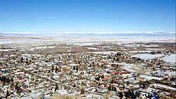 Del Norte from the summit of Lookout Mountain with the Sangre de Cristo Range in the background. | |
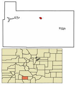 Location of Del Norte in Rio Grande County, Colorado. | |
| Coordinates: 37°40′42″N 106°21′14″W / 37.678447°N 106.353931°WCoordinates: 37°40′42″N 106°21′14″W / 37.678447°N 106.353931°W[1] | |
| Country |
|
| State |
|
| County | Rio Grande County Seat[2] |
| Incorporated | 1895-11-15[3] |
| Government | |
| • Type | Statutory Town[2] |
| Area[4] | |
| • Total | 1.01 sq mi (2.61 km2) |
| • Land | 1.01 sq mi (2.61 km2) |
| • Water | 0.00 sq mi (0.00 km2) |
| Elevation[5] | 7,884 ft (2,403 m) |
| Population (2010) | |
| • Total | 1,686 |
| • Estimate (2016)[6] | 1,598 |
| • Density | 1,586.89/sq mi (612.42/km2) |
| Time zone | UTC-7 (MST) |
| • Summer (DST) | UTC-6 (MDT) |
| ZIP code[7] | 81132 |
| Area code(s) | 719 |
| FIPS code | 08-19795 |
| GNIS feature ID | 0190305 |
The Town of Del Norte is the Statutory Town that is the county seat of Rio Grande County, Colorado, United States. The town population was 1,705 at the 2000 census.
History
Del Norte is named from the river Rio Grande del Norte, "grand river of the north".[8]
Geography
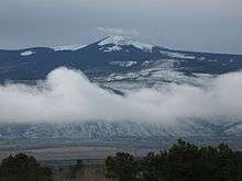
Del Norte is located at 37°40′44″N 106°21′11″W / 37.67889°N 106.35306°W (37.679015, -106.352976),[9] where the Rio Grande leaves the San Juan Mountains and enters the San Luis Valley, near its confluences with Pinos Creek and San Francisco Creek, respectively. Del Norte is located on the western edge of the San Luis Valley, which means that a variety of climates, vegetation regions, and ecosystems transition into each other at or near Del Norte. Lookout Mountain, also known to locals as 'D' Mountain, overlooks Del Norte at an official elevation of 8,475 feet above sea level, and is perhaps the most notable landmark of the town.
According to the United States Census Bureau, the town has a total area of 0.9 square miles (2.3 km2), all of it land.
Demographics
| Historical population | |||
|---|---|---|---|
| Census | Pop. | %± | |
| 1880 | 729 | — | |
| 1890 | 736 | 1.0% | |
| 1900 | 705 | −4.2% | |
| 1910 | 840 | 19.1% | |
| 1920 | 1,007 | 19.9% | |
| 1930 | 1,410 | 40.0% | |
| 1940 | 1,923 | 36.4% | |
| 1950 | 2,048 | 6.5% | |
| 1960 | 1,856 | −9.4% | |
| 1970 | 1,569 | −15.5% | |
| 1980 | 1,709 | 8.9% | |
| 1990 | 1,674 | −2.0% | |
| 2000 | 1,705 | 1.9% | |
| 2010 | 1,686 | −1.1% | |
| Est. 2016 | 1,598 | [6] | −5.2% |
| U.S. Decennial Census[10] | |||
As of the census[11] of 2000, there were 1,705 people, 657 households, and 446 families residing in the town. The population density was 2,004.4 people per square mile (774.5/km²). There were 736 housing units at an average density of 865.2 per square mile (334.3/km²). The racial makeup of the town was 66.86% White, 0.12% African American, 1.06% Native American, 0.41% Asian, 27.68% from other races, and 3.87% from two or more races. Hispanic or Latino of any race were 57.36% of the population.
There were 657 households out of which 35.3% had children under the age of 18 living with them, 47.9% were married couples living together, 15.4% had a female householder with no husband present, and 32.1% were non-families. 29.4% of all households were made up of individuals and 14.9% had someone living alone who was 65 years of age or older. The average household size was 2.57 and the average family size was 3.19.
In the town, the population was spread out with 30.2% under the age of 18, 9.4% from 18 to 24, 24.8% from 25 to 44, 22.9% from 45 to 64, and 12.8% who were 65 years of age or older. The median age was 35 years. For every 100 females, there were 94.6 males. For every 100 females age 18 and over, there were 90.7 males.
The median income for a household in the town was $23,833, and the median income for a family was $29,471. Males had a median income of $26,161 versus $21,406 for females. The per capita income for the town was $12,751. About 22.1% of families and 25.4% of the population were below the poverty line, including 36.5% of those under age 18 and 14.0% of those age 65 or over.
Climate
| Climate data for Del Norte, Colorado (Elevation 7,884ft) | |||||||||||||
|---|---|---|---|---|---|---|---|---|---|---|---|---|---|
| Month | Jan | Feb | Mar | Apr | May | Jun | Jul | Aug | Sep | Oct | Nov | Dec | Year |
| Record high °F (°C) | 61 (16) |
68 (20) |
73 (23) |
80 (27) |
87 (31) |
91 (33) |
91 (33) |
89 (32) |
87 (31) |
81 (27) |
70 (21) |
62 (17) |
91 (33) |
| Average high °F (°C) | 35.2 (1.8) |
40.1 (4.5) |
48.9 (9.4) |
58.2 (14.6) |
67.0 (19.4) |
75.4 (24.1) |
78.7 (25.9) |
76.6 (24.8) |
71.5 (21.9) |
62.1 (16.7) |
47.7 (8.7) |
37.0 (2.8) |
58.2 (14.6) |
| Average low °F (°C) | 5.7 (−14.6) |
11.3 (−11.5) |
19.1 (−7.2) |
26.7 (−2.9) |
34.8 (1.6) |
41.9 (5.5) |
47.7 (8.7) |
46.2 (7.9) |
39.1 (3.9) |
29.6 (−1.3) |
18.0 (−7.8) |
8.2 (−13.2) |
27.4 (−2.6) |
| Record low °F (°C) | −34 (−37) |
−25 (−32) |
−16 (−27) |
−4 (−20) |
10 (−12) |
26 (−3) |
32 (0) |
30 (−1) |
15 (−9) |
2 (−17) |
−20 (−29) |
−26 (−32) |
−34 (−37) |
| Average precipitation inches (mm) | 0.33 (8.4) |
0.33 (8.4) |
0.67 (17) |
0.70 (17.8) |
0.82 (20.8) |
0.65 (16.5) |
1.45 (36.8) |
1.70 (43.2) |
0.99 (25.1) |
0.80 (20.3) |
0.50 (12.7) |
0.45 (11.4) |
9.39 (238.5) |
| Average snowfall inches (cm) | 5.8 (14.7) |
5.4 (13.7) |
7.5 (19.1) |
4.5 (11.4) |
1.3 (3.3) |
0 (0) |
0 (0) |
0 (0) |
0.2 (0.5) |
2.7 (6.9) |
5.6 (14.2) |
6.6 (16.8) |
39.7 (100.8) |
| Source: The Western Regional Climate Center[12] | |||||||||||||
Notable people born here
- Alva B. Adams-US Senator representing Colorado.
- Kent Rominger-Astronaut attended Del Norte High School.
See also
References
- ↑ "2014 U.S. Gazetteer Files: Places". United States Census Bureau. July 1, 2014. Retrieved January 5, 2015.
- 1 2 "Active Colorado Municipalities". State of Colorado, Department of Local Affairs. Archived from the original on 2010-11-23. Retrieved 2007-12-04.
- ↑ "Colorado Municipal Incorporations". State of Colorado, Department of Personnel & Administration, Colorado State Archives. 2004-12-01. Retrieved 2007-09-02.
- ↑ "2016 U.S. Gazetteer Files". United States Census Bureau. Retrieved Jul 25, 2017.
- ↑ "US Board on Geographic Names". United States Geological Survey. 2007-10-25. Retrieved 2008-01-31.
- 1 2 "Population and Housing Unit Estimates". Retrieved June 9, 2017.
- ↑ "ZIP Code Lookup". United States Postal Service. Archived from the original (JavaScript/HTML) on November 23, 2010. Retrieved September 6, 2007.
- ↑ Gannett, Henry (1905). The Origin of Certain Place Names in the United States. Govt. Print. Off. p. 103.
- ↑ "US Gazetteer files: 2010, 2000, and 1990". United States Census Bureau. 2011-02-12. Retrieved 2011-04-23.
- ↑ "Census of Population and Housing". Census.gov. Archived from the original on May 12, 2015. Retrieved June 4, 2015.
- ↑ "American FactFinder". United States Census Bureau. Archived from the original on 2013-09-11. Retrieved 2008-01-31.
- ↑ "Seasonal Temperature and Precipitation Information". Western Regional Climate Center. Retrieved November 18, 2013.
External links
Municipalities and communities of Rio Grande County, Colorado, United States | ||
|---|---|---|
| City |  | |
| Towns | ||
| CDPs | ||
| Unincorporated community | ||
| Footnotes | ‡This populated place also has portions in an adjacent county or counties | |
