Columbia County, Oregon
| Columbia County, Oregon | |
|---|---|
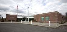
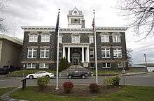 Columbia County Courthouse in St. Helens | |
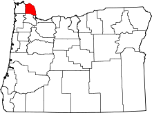 Location in the U.S. state of Oregon | |
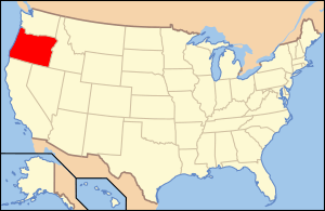 Oregon's location in the U.S. | |
| Founded | January 16, 1854 |
| Seat | St. Helens |
| Largest city | St. Helens |
| Area | |
| • Total | 688 sq mi (1,782 km2) |
| • Land | 657 sq mi (1,702 km2) |
| • Water | 31 sq mi (80 km2), 4.5% |
| Population (est.) | |
| • (2016) | 50,785 |
| • Density | 75/sq mi (29/km2) |
| Congressional district | 1st |
| Time zone | Pacific: UTC−8/−7 |
| Website |
www |
Columbia County is a county in the U.S. state of Oregon. As of the 2010 census, the population was 49,351.[1] The county seat is St. Helens.[2] It was named for the Columbia River, which forms its eastern and northern borders.
Columbia County is part of the Portland-Vancouver-Hillsboro, OR-WA Portland metropolitan area and is located in Northwest Oregon.
History
The Chinook and Clatskanie Native Americans inhabited this region for centuries prior to the arrival of Robert Gray, captain of the ship Columbia Rediviva, in 1792. The Lewis and Clark Expedition traveled and camped along the Columbia River shore in the area later known as Columbia County in late 1805 and on their return journey in early 1806.
Columbia County was created in 1854 from the northern half of Washington County. Milton served as the county seat until 1857 when it was moved to St. Helens.
Columbia County has been afflicted by numerous flooding disasters, the most recent in December 2007. Heavy rains caused the Nehalem River to escape its banks and flood the city of Vernonia and rural areas nearby. Columbia County received a presidential disaster declaration for this event.
Geography
According to the U.S. Census Bureau, the county has an area of 688 square miles (1,780 km2), of which 657 square miles (1,700 km2) is land and 31 square miles (80 km2) (4.5%) is water.[3] It is Oregon's third-smallest county by land area and fourth-smallest by total area.
Adjacent counties
- Clatsop County (west)
- Washington County (south)
- Multnomah County (southeast)
- Clark County, Washington (east)
- Cowlitz County, Washington (northeast)
- Wahkiakum County, Washington (northwest)
National protected area
Demographics
| Historical population | |||
|---|---|---|---|
| Census | Pop. | %± | |
| 1860 | 532 | — | |
| 1870 | 863 | 62.2% | |
| 1880 | 2,042 | 136.6% | |
| 1890 | 5,191 | 154.2% | |
| 1900 | 6,237 | 20.2% | |
| 1910 | 10,580 | 69.6% | |
| 1920 | 13,960 | 31.9% | |
| 1930 | 20,047 | 43.6% | |
| 1940 | 20,971 | 4.6% | |
| 1950 | 22,967 | 9.5% | |
| 1960 | 22,379 | −2.6% | |
| 1970 | 28,790 | 28.6% | |
| 1980 | 35,646 | 23.8% | |
| 1990 | 37,557 | 5.4% | |
| 2000 | 43,560 | 16.0% | |
| 2010 | 49,351 | 13.3% | |
| Est. 2016 | 50,785 | [4] | 2.9% |
| U.S. Decennial Census[5] 1790-1960[6] 1900-1990[7] 1990-2000[8] 2010-2016[1] | |||
2000 census
As of the census[9] of 2000, there were 43,560 people, 16,375 households, and 12,035 families residing in the county. The population density was 66 people per square mile (26/km²). There were 17,572 housing units at an average density of 27 per square mile (10/km²). The racial makeup of the county was 94.42% White, 0.24% Black or African American, 1.33% Native American, 0.59% Asian, 0.10% Pacific Islander, 0.79% from other races, and 2.53% from two or more races. 2.51% of the population were Hispanic or Latino of any race. 21.2% were of German, 10.8% English, 9.4% American, 9.3% Irish and 5.4% Norwegian ancestry.
There were 16,375 households out of which 34.40% had children under the age of 18 living with them, 60.50% were married couples living together, 8.70% had a female householder with no husband present, and 26.50% were non-families. 21.10% of all households were made up of individuals and 8.10% had someone living alone who was 65 years of age or older. The average household size was 2.65 and the average family size was 3.06.
In the county, the population was spread out with 27.30% under the age of 18, 7.00% from 18 to 24, 28.10% from 25 to 44, 26.00% from 45 to 64, and 11.60% who were 65 years of age or older. The median age was 38 years. For every 100 females, there were 100.00 males. For every 100 females age 18 and over, there were 98.10 males.
The median income for a household in the county was $45,797, and the median income for a family was $51,381. Males had a median income of $42,227 versus $27,216 for females. The per capita income for the county was $20,078. About 6.70% of families and 9.10% of the population were below the poverty line, including 11.60% of those under age 18 and 7.00% of those age 65 or over.
2010 census
As of the 2010 United States Census, there were 49,351 people, 19,183 households, and 13,516 families residing in the county.[10] The population density was 75.1 inhabitants per square mile (29.0/km2). There were 20,698 housing units at an average density of 31.5 per square mile (12.2/km2).[11] The racial makeup of the county was 92.5% white, 1.3% American Indian, 0.9% Asian, 0.4% black or African American, 0.2% Pacific islander, 1.2% from other races, and 3.4% from two or more races. Those of Hispanic or Latino origin made up 4.0% of the population.[10] In terms of ancestry, 26.1% were German, 14.5% were English, 14.4% were Irish, 5.9% were Norwegian, and 4.8% were American.[12]
Of the 19,183 households, 32.0% had children under the age of 18 living with them, 55.5% were married couples living together, 9.8% had a female householder with no husband present, 29.5% were non-families, and 23.3% of all households were made up of individuals. The average household size was 2.55 and the average family size was 2.98. The median age was 41.3 years.[10]
The median income for a household in the county was $55,199 and the median income for a family was $62,728. Males had a median income of $52,989 versus $35,558 for females. The per capita income for the county was $24,613. About 6.5% of families and 10.3% of the population were below the poverty line, including 12.7% of those under age 18 and 6.6% of those age 65 or over.[13]
Communities
Cities
- Clatskanie
- Columbia City
- Prescott
- Rainier
- St. Helens (county seat)
- Scappoose
- Vernonia
Census-designated places
Unincorporated communities
Government
The county is governed by an elected board of three commissioners. Each commissioner is elected to a term of four years. Other elected officials include the sheriff, county clerk, district attorney, treasurer, surveyor, assessor and justice of the peace.
Politics
In Presidential elections the county was between 1930 and 2010 among the most consistently Democratic in the United States. The last Republican to win a majority in Columbia County had been Herbert Hoover in the 1928 presidential election, although before 1930 no Democrat had won a majority in the county[14] since Samuel J. Tilden in 1876. However in 2016, Donald Trump won the county with just under fifty percent of the vote ending the tradition of choosing Democrats for president.[15] That stated, the margin had been as little as three percent in 2004[16] and in 1984.
Columbia County is part of Oregon's 1st congressional district, which is represented by Suzanne Bonamici and has a Cook Partisan Voting Index score of D+8.
| Year | Republican | Democratic | Third parties |
|---|---|---|---|
| 2016 | 49.7% 13,217 | 38.2% 10,167 | 12.2% 3,234 |
| 2012 | 45.1% 10,772 | 50.3% 12,004 | 4.6% 1,099 |
| 2008 | 42.0% 10,413 | 54.1% 13,390 | 3.9% 965 |
| 2004 | 47.6% 11,868 | 50.4% 12,563 | 2.0% 486 |
| 2000 | 44.2% 9,369 | 48.7% 10,331 | 7.1% 1,495 |
| 1996 | 33.6% 6,205 | 50.2% 9,275 | 16.2% 2,996 |
| 1992 | 26.9% 5,227 | 42.8% 8,298 | 30.3% 5,877 |
| 1988 | 40.6% 6,424 | 56.8% 8,983 | 2.5% 399 |
| 1984 | 48.5% 7,811 | 51.0% 8,219 | 0.5% 75 |
| 1980 | 42.7% 6,623 | 46.0% 7,124 | 11.3% 1,758 |
| 1976 | 37.7% 5,226 | 57.8% 8,005 | 4.5% 628 |
| 1972 | 43.5% 5,348 | 48.8% 5,997 | 7.6% 939 |
| 1968 | 38.1% 4,208 | 54.9% 6,064 | 7.0% 775 |
| 1964 | 24.2% 2,489 | 75.3% 7,728 | 0.5% 51 |
| 1960 | 44.0% 4,356 | 56.0% 5,546 | 0.1% 6 |
| 1956 | 43.3% 4,275 | 56.7% 5,592 | |
| 1952 | 47.5% 4,666 | 51.8% 5,096 | 0.7% 72 |
| 1948 | 37.0% 3,049 | 57.8% 4,768 | 5.3% 434 |
| 1944 | 33.5% 2,696 | 64.8% 5,213 | 1.7% 140 |
| 1940 | 33.7% 2,959 | 65.6% 5,758 | 0.7% 57 |
| 1936 | 23.3% 1,815 | 71.6% 5,587 | 5.1% 399 |
| 1932 | 33.3% 1,975 | 61.4% 3,643 | 5.4% 319 |
| 1928 | 65.2% 3,519 | 32.9% 1,775 | 1.9% 102 |
| 1924 | 56.2% 2,483 | 23.0% 1,015 | 20.8% 920 |
| 1920 | 61.5% 2,007 | 29.7% 970 | 8.7% 285 |
| 1916 | 54.0% 2,023 | 38.7% 1,451 | 7.4% 276 |
| 1912 | 28.1% 574 | 24.8% 507 | 47.2% 965 |
| 1908 | 63.7% 1,242 | 23.3% 454 | 13.0% 254 |
| 1904 | 74.3% 1,301 | 12.6% 221 | 13.1% 230 |
Economy
The primary industries are wood products and paper manufacturing, trade, construction and horticulture.[18][19] The extensive stands of old growth timber, which had attracted many of the early settlers to the area, were completely logged over by the 1950s.[20] Second-growth timber provides the raw material for local lumber and paper mills. About half the county's workforce commutes out of the county to work, most to the nearby Portland, Oregon, metro area.[21] Columbia County's average nonfarm employment was 10,740 in 2007.[22] The five largest private employers in Columbia County are Fred Meyer, Armstrong World Industries, Wal-Mart, Boise Paper, USIA,[23] and USG.[24]
Transportation
Public transit
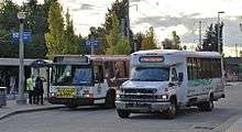
Columbia County Rider (CC Rider), a service of the Columbia County Transit Division, provides six intercity bus lines and one "flex route" serving various points of downtown St. Helens and downtown Scappoose.[25] Since 2016, CC Rider buses are operated by contract drivers supplied by MTR Western, a charter motor coach operator.[26]
The transit agency is largely funded by grants from the Oregon Department of Transportation and the federal government. Attempts at making CC Rider a separate transit district and to introduce new taxes to fund it have repeatedly failed since 2015. Columbia County and nearby Clatsop County are currently studying options on consolidating the two county's transit services.[27][28]
Single-ride fares range from $2 to $6 per ride depending on number of zones traveled. A ride to Astoria costs up to $10 per ride each way.[29][30]
| Route | Origin | Intermediate stops | Terminus | Days of operation |
|---|---|---|---|---|
| 1 Downtown Portland | St. Helens Transit Center | Warren, Scappoose, Linnton | Portland | 7 days a week |
| 2 PCC Rock Creek | St. Helens Transit Center | Scappoose, PCC Rock Creek, Tanasbourne | Willow Creek Transit Center | Weekdays |
| 3 South County Flex | St. Helens Transit Center | Scappoose, Warren | St. Helens Transit Center | Weekdays |
| 4 Clatskanie | St. Helens Transit Center | Columbia City, Deer Island, Prescott, Goble, Rainier | Clatskanie | Weekdays |
| 5 Kelso | Rainier | Kelso, Washington | Longview, Washington | 7 days a week |
| 6 Nehalem Valley | Willow Creek Transit Center | Staley's Junction, L.L. Stub Stewart State Park | Vernonia | Mondays, Wednesdays, Fridays |
| 7 Lower Columbia Connector | Portland Union Station | Scappoose, St. Helens, Columbia City, Deer Island, Prescott, Goble, Rainier | Astoria (via Sunset Empire Transportation District bus from Rainier) | 7 days a week |
Major highways
See also
References
- 1 2 "State & County QuickFacts". United States Census Bureau. Retrieved November 14, 2013.
- ↑ "Find a County". National Association of Counties. Archived from the original on 2011-05-31. Retrieved 2011-06-07.
- ↑ "2010 Census Gazetteer Files". United States Census Bureau. August 22, 2012. Retrieved February 25, 2015.
- ↑ "Population and Housing Unit Estimates". Retrieved June 9, 2017.
- ↑ "U.S. Decennial Census". United States Census Bureau. Archived from the original on May 12, 2015. Retrieved February 25, 2015.
- ↑ "Historical Census Browser". University of Virginia Library. Retrieved February 25, 2015.
- ↑ Forstall, Richard L., ed. (March 27, 1995). "Population of Counties by Decennial Census: 1900 to 1990". United States Census Bureau. Retrieved February 25, 2015.
- ↑ "Census 2000 PHC-T-4. Ranking Tables for Counties: 1990 and 2000" (PDF). United States Census Bureau. April 2, 2001. Retrieved February 25, 2015.
- ↑ "American FactFinder". United States Census Bureau. Archived from the original on 2013-09-11. Retrieved 2008-01-31.
- 1 2 3 "DP-1 Profile of General Population and Housing Characteristics: 2010 Demographic Profile Data". United States Census Bureau. Retrieved 2016-02-23.
- ↑ "Population, Housing Units, Area, and Density: 2010 - County". United States Census Bureau. Retrieved 2016-02-23.
- ↑ "DP02 SELECTED SOCIAL CHARACTERISTICS IN THE UNITED STATES – 2006-2010 American Community Survey 5-Year Estimates". United States Census Bureau. Retrieved 2016-02-23.
- ↑ "DP03 SELECTED ECONOMIC CHARACTERISTICS – 2006-2010 American Community Survey 5-Year Estimates". United States Census Bureau. Retrieved 2016-02-23.
- ↑ The Political Graveyard; Columbia County, Oregon
- ↑ Dave Leip's Atlas of U.S. Presidential Elections; Columbia County, Oregon – 2016
- ↑ Dave Leip's Atlas of U.S. Presidential Elections; Columbia County, Oregon – 2004
- ↑ Leip, David. "Dave Leip's Atlas of U.S. Presidential Elections". uselectionatlas.org. Retrieved 2018-04-11.
- ↑ Oregon Labor Market Information System
- ↑ Analysis, US Department of Commerce, BEA, Bureau of Economic. "Bureau of Economic Analysis". www.bea.gov. Retrieved 2018-04-11.
- ↑ "Oregon Secretary of State: Columbia County History". arcweb.sos.state.or.us. Retrieved 2018-04-11.
- ↑ U.S. Census Bureau
- ↑ Columbia County and Oregon QuickFacts - United States Census Bureau. (2012)
- ↑ UnderSea Industrial Apparel
- ↑ Columbia County Economic Team
- ↑ "Columbia County Rider". NW Oregon Connector. Retrieved 16 May 2018.
- ↑ "Where does CC Rider go from here?". The St. Helens Chronicle. Retrieved 16 May 2018.
- ↑ "Clatsop, Columbia transit networks look at linking". Daily Astorian. Retrieved 16 May 2018.
- ↑ "CC Rider looks at service cuts, possible transit merger". Columbia County Spotlight. Retrieved 16 May 2018.
- ↑ "7 Lower Columbia Connector" (PDF). CC Rider. Retrieved 16 May 2018.
- ↑ "1 Downtown Portland" (PDF). CC Rider. Retrieved 16 May 2018.
- ↑ "NW Oregon Connector". NW Oregon Connector. Retrieved 16 May 2018.
Municipalities and communities of Columbia County, Oregon, United States | ||
|---|---|---|
| Cities | | |
| CDPs | ||
| Other unincorporated communities | ||