Bruce Highway
| Bruce Highway Queensland | |
|---|---|
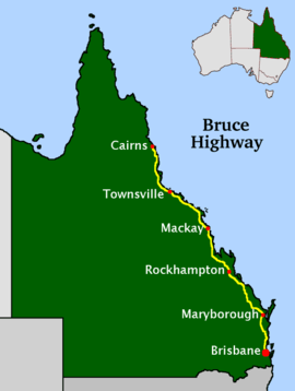 | |
| Map of Queensland with Bruce Highway highlighted in yellow | |
| General information | |
| Type | Highway |
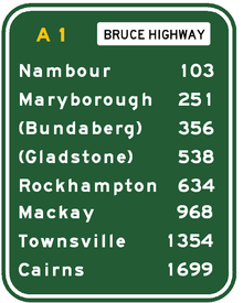
| Length | 1,679 km (1,043 mi) |
| Route number(s) |
|
| Major junctions | |
| North end |
|
| |
| South end |
|
| Location(s) | |
| Major settlements | Townsville, Mackay, Rockhampton, Maryborough |
| Highway system | |
The Bruce Highway is a major highway in Queensland, Australia. Commencing in the state capital, Brisbane, it passes through areas close to the eastern coast on its way to Cairns in Far North Queensland. The route is part of the Australian National Highway and also part of Highway 1. Its length is approximately 1,679 kilometres (1,043 mi); it is entirely sealed with bitumen. The highway is named after a popular former Queensland and federal politician, Harry Bruce. Bruce was the state Minister for Works when the highway was named after him, in the mid-1930s, and was widely considered to be a good bloke. The highway once passed through Brisbane, but was truncated at Bald Hills when the Gateway Motorway became National Highway 1 upon its opening in December 1986.
The highway is the biggest traffic carrier in Queensland. It initially joined all the major coastal centres; however, a number of bypasses, particularly in the south, have diverted traffic around these cities to expedite traffic flow and ease urban congestion. As a result, the highway is constantly being shortened. The road is a dual carriageway from Brisbane to Cooroy with some dual carriageway lengths at Gympie, many of these upgrades being completed in the 1980s (Glass House Mountains, Tanawha, Maryborough) and 1990s (Nambour, Yandina, and Cooroy).
The highway commences just south of the bridge over the Pine River at the Gateway Motorway interchange, 21 kilometres (13 mi) north of the Brisbane central business district. The highway has changed its route numbering from National Highway 1 to the M1 (motorway road) or A1 (single carriageway, generally with overtaking lanes).

Major cities along the route include Maryborough, Rockhampton, Mackay, Townsville, and Cairns. The highway passes the Glasshouse Mountains, rainforests and pastures in the Sunshine Coast, the Gunalda Range (north of Gympie), Mount Larcom (north of Gladstone), and the arid countryside north of Rockhampton; after that, it passes through land predominantly used for sugar cane, crop growing and dairy farms and the sub-tropics and tropics.
Route description
Commencing in Bald Hills at the junction of the Gateway Motorway and Gympie Arterial Road, the Bruce Highway is a motorway standard road (signed as the M1) for its first 136 kilometres (85 mi) to Kybong, where it becomes a two-lane sealed highway for most of its remainder. The first 2.5 kilometres (1.6 mi) to the Dohles Rocks Road interchange has eight lanes and a variable (electronically signed) speed limit of up to 100 kilometres per hour (60 mph). The next 22 kilometres (14 mi) to the Caboolture / Bribie Island interchange has six lanes and a maximum speed limit of 100 kilometres per hour (60 mph). From there to Kybong the road has four lanes and, with one short exception, a speed limit of 110 kilometres per hour (70 mph).
Brisbane to Maryborough
Bald Hills to Caboolture
This section of the Bruce Highway crosses the Pine River into the Moreton Bay Region, passing through mainly urban areas before crossing the Caboolture River and reaching the Caboolture / Bribie Island interchange after 24.5 kilometres (15.2 mi). It runs past or through Murrumba Downs, Griffin, Kallangur, Mango Hill, North Lakes, Dakabin, Narangba, Burpengary and Morayfield. On the way it is crossed by the Redcliffe Peninsula railway line and passes the Caboolture BP Travel Centre.
Caboolture to Caloundra
The Caboolture / Bribie Island interchange also provides access to the D'Aguilar Highway via a service road. After the D'Aguilar Highway interchange the Bruce passes through mainly rural areas and the Beerburrum and Beerwah State Forests, entering the Sunshine Coast Region before reaching the Caloundra Road interchange after a further 36.1 kilometres (22.4 mi). It passes the southern entry to Steve Irwin Way, a bypassed section of the highway, which provides access to Beerburrum, Glass House Mountains, Beerwah, Australia Zoo and Landsborough before terminating at the Caloundra Road interchange.
Caloundra to Noosa
The next 5.6 kilometres (3.5 mi) to the Sunshine Motorway interchange, providing access to the Sunshine Coast, has a speed limit of 100. The speed limit then reverts to 110. After another 7.5 kilometres (4.7 mi) the Maroochydore Road interchange provides access to Maroochydore and Woombye. The Bli Bli Road interchange, after a further 7 kilometres (4.3 mi), provides access to Bli Bli and Nambour. The Yandina–Coolum Road interchange, after 6.7 kilometres (4.2 mi), provides access to Yandina and Coolum. The Eumundi interchange, after 8.4 kilometres (5.2 mi), provides access to Eumundi and Noosa. The Cooroy interchange, after 7.2 kilometres (4.5 mi), provides access to Cooroy, Tewantin and Noosa. Total distance from Caloundra Road to this interchange is 42.4 kilometres (26.3 mi).
Noosa to Gympie
The 33 kilometres (21 mi) to the end of the M1 at Kybong includes three interchanges that provide access to the Old Bruce Highway. From Kybong the highway is designated A1. It has numerous parts with lower speed limits, including urban areas, high crash zones and roadwork sites. After 8 kilometres (5.0 mi) from Kybong the Mary Valley Road interchange provides access to the west of the Mary River. The highway then passes through the Gympie urban fringe, with several at grade intersections providing access to various parts of the city. North of Gympie, 14.3 kilometres (8.9 mi) from the Mary Valley Road interchange, the Wide Bay Highway interchange is reached, providing access to Kilkivan. Total distance from the Cooroy interchange is 55.4 kilometres (34.4 mi).
Gympie to Maryborough
The 73.9 kilometres (45.9 mi) from the Wide Bay Highway interchange to the Maryborough–Biggenden Road interchange at Maryborough passes through Tiaro and the Gympie Road exit to Maryborough before crossing the Mary River.
Development of the M1
With the completion of Section C of the Bruce Highway - Cooroy to Curra upgrade project (Traveston to Woondum) in February 2018[1] the M1 has now been extended to Kybong, 10 kilometres (6.2 mi) south of Gympie. The Bruce Highway from Kybong to Gympie remains signed as A1. Section D of the project (Woondum to Curra, including a bypass of Gympie)[2] will, when completed, become the next stage of the M1.
Note: While the references use Woondum as a designator for sections of the project the new intersection that marks the end of the M1 is wholly within the locality of Kybong, although bordered on two sides by Woondum.[3][4]
History
Note: The information in this section is derived from Google Maps and other Wikipedia articles.
Remnants of early roads to the north of Brisbane
Roads to the north of Brisbane in the early days of settlement were constrained by the need to use reliable low level crossings of rivers and creeks well upstream from the coast.
South Pine Road runs from Enoggera Road at Alderley through Everton Park to Everton Hills.[5]
Bunya Road runs from South Pine Road at Everton Hills to Eatons Crossing Road at Draper,[6] after crossing the South Pine River at Drapers Crossing (a fordable crossing).
Old Northern Road runs from South Pine Road at Everton Park to another South Pine Road at Albany Creek.[7] Eatons Crossing Road runs from this road (north of the South Pine River) to Draper.[8] This South Pine Road continues north over the South Pine River via Eatons Crossing and thence to Gympie Road at Strathpine.[9]
Old North Road links this South Pine Road at Brendale to Youngs Crossing Road at Bray Park. Youngs Crossing Road continues to Dayboro Road at Petrie after crossing the North Pine River.[10] Further upstream, Whiteside Road[11] (now submerged by Lake Samsonvale) provided a fordable crossing at Quinn's Crossing[12] when water level was too high at Youngs Crossing.
Further north, another segment of Old North Road starts at Caboolture River Road in Upper Caboolture, crosses the Caboolture River at Zillmans Crossing[13] and proceeds to Wamuran.[14]
Early roads from the North Pine River crossing to the Caboolture River crossing may have included parts of:
- Narangba Road from Anzac Avenue in Kallangur to Narangba, where it becomes (after a short distance as Main Street) Oakey Flat Road , to Morayfield Road at Morayfield.[15]
- Burpengary Road from Boundary Road at Dakabin to Burpengary, where it becomes Station Road. From Station Road the direct route to Morayfield follows Obrien Road and Lindsay Road.[16]
- Old Gympie Road from Anzac Avenue in Kallangur to Morayfield Road at Burpengary.[17]
- Caboolture River Road from Morayfield Road at Morayfield to Old North Road at Upper Caboolture.[18]
The Oakey Flat Road route avoids the crossing of Burpengary Creek on Obrien Road at Burpengary. From Oakey Flat Road at Morayfield a route consisting of Williamson Road, Forest Hills Drive, Haywood Road and Moorina Road runs to Caboolture River Road at Upper Caboolture,[19] avoiding the crossing of Sheep Station Creek on Morayfield Road at Morayfield.
Early roads from Caboolture (after travelling east from Wamuran) to Landsborough and then to the Bruce Highway at Palmview may have included parts of:
- Another segment of Old Gympie Road from Caboolture to Landsborough.[20]
- Beerburrum Road from Caboolture to Beerburrum,[21] where it joins the Steve Irwin Way to Landsborough and Palmview.
Tom Petrie’s roads
Several Wikipedia articles contain information relating to the involvement of Tom Petrie in the development of roads to the north of Brisbane.
Murrumba Homestead Grounds
The following quotations are from the Murrumba Homestead Grounds article.[22]
- "To facilitate his timber operations Tom Petrie marked out several early northern roads, including a track between the Pine River and Bald Hills and a trail from Murrumba to Maroochydore, which later became the Gympie Road. He also blazed a track from North Pine to Humpybong (Redcliffe)."
- "In 1869 Cobb & Co opened a coach route from Brisbane to Gympie via the route Tom had helped mark out."
Anzac Avenue
Note: Anzac Avenue is part of the history of the Bruce Highway as the highway followed it from Petrie to Rothwell for many years prior to the construction of its present alignment.
The following quotation is from the Anzac Avenue article.[23]
- "A road from Bald Hills to Redcliffe was formed by the early 1860s, but by 1864 this was almost impassable. Tom Petrie marked a track from the Hays Inlet crossing and in the early 1870s assisted in surveying the road. Known as the "Brisbane Road" it became the primary way of accessing the Redcliffe Peninsula by road."
Upgrades
One of the most dramatic deviations of the highway was the Bald Hills to Burpengary Deviation. Beginning construction in 1972, the new route took traffic from Gympie Road at Bald Hills to Uhlmann Road at Burpengary along a much superior alignment which was also constructed to four lanes. The new route was officially opened on 10 November 1977 at a total cost of $20 million.[24]
Due to the nature of wet weather and tropical cyclone prone areas of North Queensland, the highway is prone to frequent flooding in a number of places. Following the catastrophic Queensland floods in 2010–2011 the Australian Government commissioned a feasibility study on flood-proofing the highway.[25]
Numerous stretches of the highway are set to undergo redevelopment, realignment, flood-proofing and extension of dual carriageway sections.[26] Former Premier Anna Bligh announced the plans while launching the Queensland Infrastructure Plan. The works are expected to total A$2 billion and include 60 projects over a period of two decades.[26]
A stretch of road between Cardwell and Tully, which is prone to frequent flooding in the wet season, is set to undergo realignment. A new route for the highway through Townsville was under construction with the first stage of the Townsville Ring Road (now called The Ring Road) already completed.
An upgrade to a stretch of the highway north of Townsville has been given approval, and will see the existing dual carriageway to the north extended by another 5–10 km. It will also include installation of traffic lights at Mt Low Parkway, and will be the final stage of the Ring Road link up to this section by 2015. The Queensland Main Roads Department's ultimate concept map of the development shows that the highway will progressively become Motorway standard by 2015, with the implementation of interchanges at various junctions.
The highway south of Cairns will see sections of the highway to the suburb of Edmonton become six lanes, with progressive dual-carriageway redevelopment of the highway to Gordonvale.
To improve flood immunity of the highway south of Childers, a new and improved road alignment and a higher bridge over the Isis River were completed in September 2011.[27]
Between Caboolture and the Gateway Motorway, the highway has been widened to eight and six lanes since 2001, including the Dohles Rocks Road to Boundary Road section in October 2004, the Boundary Road to Uhlmann Road section in March 2007, and the latest section Uhlmann Road to Bribie Island Road in November 2009. Further upgrades are under review.
A new interchange has been built at the notorious intersection of Roys Road at Beerwah. It also connects to the nearby Bells Creek Road, eliminating another dangerous intersection.[28] This follows a similar situation at Buchanans Road in Morayfield, the intersection of which was replaced by an interchange in November 1996.
The Pumicestone Road interchange has also undergone a redesign, replacing the original low-level bridge and ramps constructed in October 1970.
The Nambour Bypass has recently gone through a process of rehabilitation due to the extremely rough surface and dangerous pothole appearances during wet weather. This work was completed in 2009.
As of 2014 Section B of the joint State and Federal funded 61 kilometres (38 mi) Cooroy to Curra upgrade of the highway is open. Due to the new highway change, one of the local schools, Federal State School, was relocated. Early works for Section A has commenced. When completed, the Cooroy to Curra upgrade will bypass the town of Gympie and a mainly 2 lane section will be replaced with a 4 lane dual-carriageway.[29]
Major upgrades: Bald Hills to Cooroy
| Date | Details |
|---|---|
| August 1966 | Caboolture Bypass Stage 1. Single-carriageway completed between Burpengary Creek and Bribie Island Road.[30] |
| August 1970 | Caboolture Bypass Stage 2. Single-carriageway completed between Bribie Island Road and Red Road.[31] |
| December 1972 | Single-carriageway deviation between Eumundi and Cooroy, bypassing Eumundi Range Road.[32] |
| December 1973 | Bald Hills to Burpengary Deviation Stage 1. 1.3 mile-long dual-carriageways completed between Roghan Road and Strathpine Road.[33] |
| December 1973 | Beerwah Bypass. 2.5 km-long deviation completed between Roys Road and Foley Road including a new concrete bridge across Coochin Creek.[33] |
| November 1974 | Browns Creek Deviation. 6 km-long single-carriageway completed between Browns Creek and Eerwah Vale.[34] |
| December 1974 | Glasshouse Mountains Bypass. 1.5 km-long deviation completed between Glasshouse Mountains Sportsground and Kings Road including a new concrete bridge across Coonowrin Creek.[34] |
| August 1976 | Eumundi Bypass. 2.4 km-long deviation completed between Eerwah Vale and Main Creek.[35] |
| 2 August 1976 | Bald Hills to Burpengary Deviation Stage 2. 12 km-long single-carriageway deviation completed between Strathpine Road and Boundary Road.[35] |
| March 1977 | Bald Hills to Burpengary Deviation Stage 3. Second carriageway completed between Strathpine Road and Anzac Avenue.[35] |
| 10 November 1977 | Bald Hills to Burpengary Deviation Stage 4. Boundary Road to Deception Bay Road section completed.[36] |
| 5 December 1978 | Bribie Island Road Interchange.[37] |
| 9 August 1979 | Burpengary to Bribie Island Road Duplication. Second carriageway completed between Burpengary Creek and Bribie Island Road.[38] |
| 9 December 1985 | Beerburrum Creek to Caloundra Road Deviation. Major 26.5 km-long four lane deviation completed between Beerburrum Creek and Caloundra Road.[39] |
| September 1987 | Caloundra Road to Sippy Creek duplication |
| December 1987 | Station Road Overpass (at Burpengary) |
| 16 November 1989 | Tanawha Deviation. Four lane deviation completed between Caloundra Road and Maroochydore Road. |
| January 1990 | Johnston Road Interchange. Grade-separated diamond interchange completed as part of Moby Vic's Service Centre development. |
| 23 November 1990 | Nambour Bypass Stage 1. Single-carriageway bypass of Nambour completed between Maroochydore Road and Parklands. |
| December 1992 | Dohles Rocks Road half-interchange |
| 20 December 1993 | Nambour Bypass Stage 2. Second carriageway completed between Maroochydore Road and Parklands. |
| April 1994 | Deception Bay Road northbound loop ramp |
| 17 May 1994 | Cooroy Bypass. Single-carriageway bypass of Cooroy officially opened by Minister for Transport David Hamill.[40] |
| 17 July 1997 | Yandina Bypass. Dual-carriageway bypass of Yandina officially opened by Federal Minister for Transport John Sharp.[41] |
| 23 July 2002 | Gateway Motorway to Dohles Rocks Road six-laning. |
| 19 September 2003 | Yandina to Cooroy Duplication. Dual-carriageways completed between Browns Creek and Eumundi Range. |
| 20 January 2005 | Dohles Rocks Road to Boundary Road six-laning. Six-lane upgrade completed between Dohles Rocks Road and Boundary Road, including upgrades to the Anzac Avenue interchange.[42] |
| 12 March 2007 | Boundary Road to Uhlmann Road six-laning. Six-lane upgrade completed between Boundary Road and Uhlmann Road, including upgrades to the Deception Bay Road and Uhlmann Road interchanges.[43] |
| 5 November 2009 | Uhlmann Road to Bribie Island Road six-laning. Six-lane upgrade completed between Uhlmann Road and Bribie Island Road, including upgrades to the Bribie Island Road interchange. |
Major upgrades: Cooroy to Rockhampton
| Date | Details |
|---|---|
| May 1940 | Wallaville - Burnett River Bridge |
| December 1967 | Ambrose to Raglan Deviation |
| April 1973 | Gunalda Bypass |
| 1974 | Gavial Deviation (Rockhampton) - Roope Road to Egan's Hill |
| April 1975 | Calliope River Bridge |
| August 1976 | Bauple Bypass |
| May 1977 | Bajool Bypass |
| May 1984 | Howard-Torbanlea Deviation |
| 7 October 1986 | Rockhampton Deviation – Yeppen Yeppen Crossing to Egan's Hill |
| 14 September 1990 | Maryborough Bypass |
| 16 November 1991 | Glenwood Deviation |
| 5 July 1999 | Wallaville Deviation - Tim Fischer Bridge |
| 14 February 2001 | Gunalda Range Deviation |
| August 2011 | Isis River Bridge replacement |
| 18 December 2012 | Cooroy to Curra Upgrade Section B |
| 28 October 2013 | Rockhampton – Yeppen North |
| 11 June 2014 | Calliope Interchange |
| 22 October 2015 | Rockhampton - Yeppen South |
| 5 May 2017 | Cooroy to Curra Upgrade Section A |
| 9 November 2017 | Cooroy to Curra Upgrade Section C |
Major upgrades: Rockhampton to Townsville
| Date | Details |
|---|---|
| 10 May 1973 | Bowen - Don River Bridge |
| January 1975 | Parkhurst - Ramsey Creek Bridge |
| 23 December 1977 | Mackay - Bakers Creek Deviation |
| 12 July 1980 | Mackay Deviation – Ron Camm Bridge |
| 16 August 1980 | Rockhampton Deviation – Neville Hewitt Bridge |
| 29 October 1982 | Marlborough-Sarina alignment change |
| September 1984 | Thoopara - 3.4 km deviation and new bridge over O'Connell River |
| 1991 | Mackay City Gates - Realignment of Nebo Road at the City Gates with provision of an overpass to allow for future North Coast Railway realignment (railway realignment officially opened in 1993) |
| July 1993 | Barratta - Collinsons Lagoon realignment |
| December 1993 | Barratta - Middle and East Barratta Creek realignments |
| 20 April 1994 | Yaamba/Milman Deviation - new alignment with higher-level bridges at Alligator and Plentiful Creeks in response to 1991 Flood |
| 1995 | Townsville - Charles N. Barton Bridge Duplication |
| 18 December 1998 | Mackay - Ron Camm Bridge duplication |
| December 2009 | Mackay - Boundary Road to Farrellys Lane duplication and intersection upgrade |
| 2012 | Mackay - Boundary Road to City Gates intersection upgrades |
| October 2013 | Mackay - Farrellys Road to Temples Lane duplication and intersection upgrades |
| February 2015 | Brandon - Sandy Corner to Collinsons Lagoon realignment for flood mitigation and cane rail overpass |
| October 2015 | Townsville - Vantassel Street to Cluden Drive duplication, rail overpass and intersection upgrades |
Major upgrades: Townsville to Cairns
| Date | Details |
|---|---|
| 1959 | Gordonvale/Aloomba Bypass Stage 1: Swan Creek to Riverstone Road, including Carl Wordsworth Bridge |
| 1961 | Gordonvale/Aloomba Bypass Stage 2: Mackey's Creek to Riverstone Road, bypass of Gordonvale |
| 1962 | Rollingstone Deviation |
| 1963 | Gordonvale/Aloomba Bypass Stage 3: Swan Creek to Leumann Road, bypass of Aloomba |
| 1966 | Gordonvale/Aloomba Bypass Stage 4: Leumann Road to Assman Road |
| 1968 | Bellenden Ker Deviation |
| 28 September 1968 | Ingham Deviation - John Row Bridge at Herbert River |
| December 1968 | Bellenden Plains / Murray River Deviation - replaced in 2008 by Tully Deviation |
| October 1971 | Townsville - Black River Bridge |
| 9 July 1973 | Innisfail Deviation – Centenary Bridge |
| 1980s | Townsville - Partial realignment of Bruce Highway. Alignment shifted off of Ingham Road onto Woolcock Street between Charters Towers Road and Hugh Street |
| 1981 | Innisfail - Sir Joseph McAvoy Bridge |
| 10 November 1984 | Rollingstone Creek - High-level bridge |
| 23 April 1987 | Cardwell Range Deviation (South) |
| 4 December 1987 | Mutarnee - Ollera Creek Bridge and Mutarnee Deviation |
| 17 October 1991 | Babinda Deviation Stage 1: Lloyd's Corner/Stager Road to Munro Street |
| 1992 | Babinda Deviation Stage 2: Munro Street to Nelson Road |
| 1993 | Babinda Deviation Stage 3: Nelson Road to Frenchmans Creek |
| March 1998 | Townsville Deviation – Woolcock Street extension. Alignment of National Highway 1 officially moved from Ingham, Charters Towers, Bowen Roads and Stuart Drive. |
| 1999 | Edmonton Deviation - realignment and four-laning |
| 2002 | Cairns - Ray Jones Drive to Sheehy Road six-laning |
| 2004 | Cairns - Sheehy Road to Foster Road six-laning |
| 2008 | Tully deviation |
| 17 April 2009 | Townsville Ring Road Stage 3 - National Highway A1 moved from Nathan and Duckworth Streets onto Shaw Road, continuing into The Ring Road. |
| 20 April 2009 | Higher-level Mulgrave River Bridge - Desmond Trannore Bridge |
| June 2009 | Mount Low Overpass Townsville |
| 1 November 2013 | Cardwell Range Deviation (North) [44] |
| May 2014 | Cairns Southern Access Upgrade – Stage 1 |
| December 2016 | Townsville Ring Road Stage 4 - National Highway A1 officially moved from Shaw Road |
| August 2017 | Cairns Southern Access Upgrade – Stage 2: Foster Road to Robert Road six-laning |
Projects
| Project | Length (km) | Construction dates | Value | Status | Description | Distance from Brisbane (km) | |
|---|---|---|---|---|---|---|---|
| Start | End | ||||||
| Caloundra Road to Sunshine Motorway | 7 | 18 May 2017[45] | Late 2020[45] | $929.3 million[45] | Under construction | Six lane motorway and new service road along existing alignment. Diverging diamond interchange at Caloundra Road. | 84 |
| Cooroy to Federal | 13.5 | July 2013[46] | Late 2016[46] | $590 million[46] | Under construction | Section A of Cooroy to Curra. Four lane divided highway, new alignment. | 126 |
| Federal to Traveston | 12 | September 2009[47] | December 2012[47] | $513 million[47] | Complete | Section B of Cooroy to Curra. Four lane divided highway, new alignment. | 140 |
| Yeppen South | 2.8 | 27 November 2013[48] | 2016[48] | $296 million[48] | Under construction | New elevated crossing across the Yeppen Floodplain as additional carriageway | 628 |
| Yeppen North | 1 | 27 November 2013[49] | $85 million[49] | Complete | Safety and traffic flow improvements | 631 | |
| Mackay Ring Road (Stage 1) | 11.3 | Mid 2017[50] | Late 2019[50] | $560 million[50] | In planning | Two lane highway, new alignment. | 963 |
| Townsville Ring Road (Section 4) | 11 | TBA | TBA | $200 million[51] | In planning | 4 lane motorway, new alignment. | 1366 |
| Cairns Bruce Highway Upgrade (Sheehy Road to Ray Jones Drive) | 3.4 | 2010[52] | April 2014[52] | $150 million[52] | Complete | New interchanges, widening of road | 1696 |

Highway towns
Travelling north, the following towns and small cities are found on (or very close to) the Bruce Highway.
Major intersections
M1
To avoid unnecessary length this table does not show any bridges (see River crossings below)
| LGA | Location | km[53] | mi | Exit[54] | Destinations | Notes |
|---|---|---|---|---|---|---|
| Brisbane | Bald Hills | 0 | 0.0 | 127 | Gympie Arterial Road (M3) south - Brisbane | Southern highway terminus; partial Y interchange: no access between Gateway Motorway and Gympie Arterial Road |
| Moreton Bay | Griffin–Murrumba Downs boundary | 2.5 | 1.6 | 130 | Dohles Rocks Road – Murrumba Downs, Griffin | Half-diamond interchange: northbound exit and southbound entrance |
| Kallangur–Mango Hill– North Lakes tripoint | 5.6 | 3.5 | 133 | Parclo interchange | ||
| North Lakes–Dakabin–Narangba tripoint | 10.3 | 6.4 | 138 | Boundary Road – Dakabin, Deception Bay | Parclo interchange | |
| Deception Bay–Burpengary boundary | 14.1 | 8.8 | 142 | west – Burpengary, Narangba | ||
| Burpengary | 18.6 | 11.6 | 146 | Uhlmann Road (no shield) - east – Burpengary East | ||
| Burpengary–Morayfield boundary | 20.3 | 12.6 | — | Caboolture BP Travel Centre | ||
| Morayfield | 22.1 | 13.7 | 150 | Buchanan Road – Morayfield | Dumbbell interchange | |
| Caboolture | 24.5 | 15.2 | 152 | Lower King Street west / Bribe Island Road east – Caboolture, Bribie Island | Parclo interchange; northern ramps merge with D'Aguilar Highway southern ramps | |
| 26.1 | 16.2 | Trumpet interchange | ||||
| Caboolture–Elimbah boundary | 29.6 | 18.4 | 157 | Pumicestone Road – Elimbah, Toorbul, Donnybrook | Diamond interchange, upgrade currently under construction | |
| Elimbah | 35.5 | 22.1 | 163 | |||
| Sunshine Coast | Glass House Mountains– Coochin Creek boundary | 43.2 | 26.8 | 171 | Johnston Road – Mobil Service Centre, Wild Horse Mountain Lookout | |
| Meridan Plains–Glenview boundary | 60.6 | 37.7 | 188 | Parclo interchange | ||
| Palmview | 61.8– 64.0 | 38.4– 39.8 | 190 | Fizzo Road north / Pignata Road south – Glenview, Palmview | Frontage roads | |
| Tanawha–Sippy Downs boundary | 66.2 | 41.1 | 194 | |||
| Forest Glen–Chevallum boundary | 71.5– 72.5 | 44.4– 45.0 | 200 | Mons Road – Forest Glen, Buderim | ||
| Woombye | 73.7 | 45.8 | 201 | Roundabout interchange | ||
| Bli Bli–Nambour boundary | 80.7 | 50.1 | 208 | Dumbbell interchange | ||
| Bli Bli–Parklands–Kulangoor[55] tripoint | 83.0 | 51.6 | 210 | Nambour Connection Road – Parklands | Partial parclo interchange: no northbound entrance ramp | |
| Yandina | 87.4 | 54.3 | 215 | Dumbbell interchange | ||
| Eumundi | 95.8 | 59.5 | 224 | Hybrid interchange; northbound exit and southbound entrance only | ||
| Eerwah Vale | 98.5 | 61.2 | — | Memorial Drive / Eumundi–Kenilworth Road – Eumundi, Noosa, Kenilworth | Hybrid interchange; southbound exit and northbound entrance only | |
| Noosa | Cooroy | 103 | 64 | 230 | Trumpet interchange | |
| Gympie | Traveston | 127 | 79 | — | Traveston Road - north-east – Traveston / Old Bruce Highway - south-west – Amamoor | Trumpet interchange |
| Kybong | 135– 137 | 84– 85 | — | Old Bruce Highway - south – Kybong | Route transition: northern end of M1, southern end of A1; No northbound exit from M1 to Old Bruce Highway southbound; No southbound entry to M1 from Old Bruce Highway northbound. | |
1.000 mi = 1.609 km; 1.000 km = 0.621 mi
| ||||||
A1
To avoid unnecessary length this table does not show any bridges (see River crossings below)
| LGA | Location | km[56] | mi | Exit | Destinations | Notes |
|---|---|---|---|---|---|---|
| Gympie | Gympie | 143 | 89 | |||
| Bells Bridge | 158 | 98 | ||||
| Fraser Coast | Tinana | 226 | 140 | |||
| Maryborough West / Maryborough midpoint | 231 | 144 | Alice Street - south-east - Maryborough | |||
| Bundaberg | Childers | 288 | 179 | |||
| Apple Tree Creek–North Isis[57] boundary | 295 | 183 | Partially grade separated | |||
| Gin Gin | 342 | 213 | ||||
| Gladstone | Benaraby–Wurdong Heights[58] boundary | 489 | 304 | |||
| Calliope | 501 | 311 | Diamond interchange with additional looped ramp | |||
| Mount Larcom | 535 | 332 | ||||
| Rockhampton | Gracemere–Port Curtis boundary | 604 | 375 | |||
| Port Curtis–Fairy Bower[59] boundary | 606 | 377 | Roundabout | |||
| Rockhampton | 611 | 380 | Fitzroy Street to Rockhampton–Emu Park Road – Emu Park | |||
| Parkhurst | 619 | 385 | ||||
| Mackay | Sarina | 912 | 567 | |||
| Ooralea–Paget–West Mackay tripoint[60] | 942 | 585 | ||||
| Hampden | 972 | 604 | ||||
| Whitsunday | Hamilton Plains | 1,070 | 660 | |||
| Bowen | 1,136 | 706 | ||||
| Townsville | Stuart | 1,322 | 821 | Southern Port Road - north - South Townsville, Port of Townsville | ||
| Cluden | 1,324– 1,325 | 823– 823 | Cluden Street - south - Stuart | |||
| Cluden, Idalia, Wulguru, Annandale quadpoint | 1,326 | 824 | Stuart Drive - north-west - Townsville / south-east - Stuart | |||
| Annandale, Douglas, Mount Stuart tripoint | 1,331 | 827 | University Road - north-west – Garbutt | Junction of M1 and former Bruce Highway. (Southern end of Townsville Ring Road) No southbound exit to or entry from University Road. | ||
| Bohle Plains | 1,339– 1,340 | 832– 830 | east – Thuringowa Central | |||
| Deeragun / Mount Low boundary | 1,350 | 840 | (former) Bruce Highway - east - Townsville | Junction of M1 and former Bruce Highway. (Northern end of Townsville Ring Road) | ||
| Johnstone | Belvedere–Goondi boundary | 1,595 | 991 | |||
| Cairns | Gordonvale | 1,655 | 1,028 | |||
| Cairns | 1,679 | 1,043 | Northern highway terminus | |||
| 1.000 mi = 1.609 km; 1.000 km = 0.621 mi | ||||||
Route of former Bruce Highway through Townsville
The former Bruce Highway diverts from the A1 at the Annandale, Douglas, Mount Stuart tripoint (1,331 kilometres (827 mi) from start - see Major intersections - A1) and rejoins at the Deeragun / Mount Low boundary (1,350 kilometres (840 mi) from start) It runs north as University Road, crossing the Ross River via the Charles N Barton Bridge and continuing north as Nathan Street. It crosses Ross River Road (State Route 72) and Dalrymple Road, continuing north as Duckworth Street. It then turns west into Woolcock Street, crossing Louisa Creek and the Bohle River before turning north-west to rejoin the A1 after crossing Saunders Creek and Stony Creek. Total distance is 17 kilometres (11 mi), compared to almost 19 kilometres (12 mi) on the A1.
River crossings
The accompanying diagram shows the crossings of all named rivers by the Bruce Highway.
| Bruce Highway river crossings From North to South | |||||||||||||||||||||||||||||||||||||||||||||||||||||||||||||||||||||||||||||||||||||||||||||||||||||||||||||||||||||||||||||||||||||||||||||||||||||||||||||||||||||||||||||||
|---|---|---|---|---|---|---|---|---|---|---|---|---|---|---|---|---|---|---|---|---|---|---|---|---|---|---|---|---|---|---|---|---|---|---|---|---|---|---|---|---|---|---|---|---|---|---|---|---|---|---|---|---|---|---|---|---|---|---|---|---|---|---|---|---|---|---|---|---|---|---|---|---|---|---|---|---|---|---|---|---|---|---|---|---|---|---|---|---|---|---|---|---|---|---|---|---|---|---|---|---|---|---|---|---|---|---|---|---|---|---|---|---|---|---|---|---|---|---|---|---|---|---|---|---|---|---|---|---|---|---|---|---|---|---|---|---|---|---|---|---|---|---|---|---|---|---|---|---|---|---|---|---|---|---|---|---|---|---|---|---|---|---|---|---|---|---|---|---|---|---|---|---|---|---|---|
| |||||||||||||||||||||||||||||||||||||||||||||||||||||||||||||||||||||||||||||||||||||||||||||||||||||||||||||||||||||||||||||||||||||||||||||||||||||||||||||||||||||||||||||||
Queensland Electric Super Highway
To facilitate the use of electric vehicles the Queensland Government has installed fast chargers in convenient, safe locations close to major highways where there are existing amenities such as cafes, restaurants and shops. This network is collectively described as the Queensland Electric Super Highway. For a limited time charging electric vehicles at these stations will be free. The majority of these are along the Bruce Highway, at the locations listed below (from south to north):[61]
- Cooroy
- Maryborough
- Childers
- Miriam Vale
- Rockhampton
- Marlborough
- Carmila
- Mackay
- Bowen
- Townsville
- Tully
- Cairns
Precise locations
Only two of the charging stations are on the highway. They are at Marlborough and Carmila (Puma Service Stations) The others are some distance from the highway in car parks or other places as listed in the reference.[62] Note that the reference does not include the precise location of the Townsville charging station.
Distances
The greatest distance between charging stations is about 216 km from Townsville to Tully. Other stages greater than 150 km (which may exceed the range of some electric vehicles) are:
- Childers to Miriam Vale (about 155 km)
- Miriam Vale to Rockhampton (about 170 km)
- Mackay to Bowen (about 191 km)
- Bowen to Townsville (about 202 km)
See also
References
- ↑ "Bruce Highway - Cooroy to Curra, Section C: Traveston to Woondum". Queensland Government. 9 March 2018. Archived from the original on 17 March 2018. Retrieved 17 March 2018.
- ↑ "Bruce Highway (Cooroy to Curra)". Queensland Government. 9 March 2018. Archived from the original on 17 March 2018. Retrieved 17 March 2018.
- ↑ "Woondum, QLD 4570". Whereis Maps. Archived from the original on 23 May 2018. Retrieved 18 March 2018.
- ↑ "Kybong, Queensland 4570". Google Maps. 2018. Retrieved 18 Mar 2018.
- ↑ South Pine Road - Alderley to Everton Hills (Map). Retrieved 25 Sep 2018.
- ↑ Bunya Road - Everton Hills to Draper (Map). Retrieved 25 Sep 2018.
- ↑ Old Northern Road - Everton Park to Albany Creek (Map). Retrieved 25 Sep 2018.
- ↑ Eatons Crossing Road - Eatons Hill to Draper (Map). Retrieved 25 Sep 2018.
- ↑ South Pine Road - Albany Creek to Strathpine (Map). Retrieved 25 Sep 2018.
- ↑ Old North Road and Youngs Crossing Road - Brendale to Petrie (Map). Retrieved 25 Sep 2018.
- ↑ Whiteside Road - Western and eastern ends (Map). Retrieved 25 Sep 2018.
- ↑ "The Story of Whiteside". www.npra.org.au. North Pine Residents Association. 1988. Retrieved 25 Sep 2018.
Quinns Crossing on the Petrie to Samsonvale Road, part of the first main road north of Brisbane
- ↑ Tracey Lloyd (29 Jan 2010). "Caboolture River Road Heritage Drive". www.weekendnotes.com. OatLabs ABN: 18113479226. Retrieved 25 Sep 2018.
Zillmans Crossing ... marks the original trail from Brisbane to Caboolture.
- ↑ Old North Road - Upper Caboolture to Wamuran (Map). Retrieved 25 Sep 2018.
- ↑ Narangba Road and Oakey Flat Road - Kallangur to Morayfield (Map). Retrieved 25 Sep 2018.
- ↑ Burpengary Road to Lindsay Road - Dakabin to Morayfield (Map). Retrieved 26 Sep 2018.
- ↑ Old Gympie Road - Kallangur to Burpengary (Map). Retrieved 26 Sep 2018.
- ↑ Caboolture River Road - Morayfield to Upper Caboolture (Map). Retrieved 26 Sep 2018.
- ↑ Williamson Road, Morayfield to Moorina Road, Upper Caboolture (Map). Retrieved 26 Sep 2018.
- ↑ Old Gympie Road - Caboolture to Landsborough (Map). Retrieved 26 Sep 2018.
- ↑ Beerburrum Road - Caboolture to Beerburrum (Map). Retrieved 26 Sep 2018.
- ↑ "Murrumba Homestead Grounds (former) (entry 602370)". Queensland Heritage Register. Queensland Heritage Council. Retrieved 1 August 2014.
- ↑ "Anzac Memorial Avenue (former) (entry 602693)". Queensland Heritage Register. Queensland Heritage Council. Retrieved 1 August 2014.
- ↑ Caboolture in 1970's Archived 9 April 2013 at the Wayback Machine.. Retrieved on 2 February 2012.
- ↑ Geoff Chambers (8 January 2011). "Queensland flood victims overwhelmed by damage". Daily Telegraph. Archived from the original on 30 September 2012. Retrieved 19 January 2011.
- 1 2 "Bligh announces Bruce Hwy upgrade". Sky News. Australian News Channel. 12 July 2011. Archived from the original on 26 March 2012. Retrieved 5 September 2011.
- ↑ "Bruce Highway Upgrade Isis River Bridge". Department of Transport and Main Roads. 15 February 2011. Archived from the original on 24 February 2011. Retrieved 23 February 2011.
- ↑ "Bruce Highway overpass opens at Beerwah". Queensland Government. 28 September 2015. Archived from the original on 20 January 2018. Retrieved 20 January 2018.
- ↑ "Archived copy". Archived from the original on 29 October 2013. Retrieved 25 August 2013.
- ↑ Department of Main Roads Annual Report 1966-1967
- ↑ Department of Main Roads Annual Report 1970-1971
- ↑ Department of Main Roads Annual Report 1972-1973
- 1 2 Department of Main Roads Annual Report 1973-1974
- 1 2 Department of Main Roads Annual Report 1974-1975
- 1 2 3 Department of Main Roads Annual Report 1976-1977
- ↑ Department of Main Roads Annual Report 1977-1978
- ↑ Department of Main Roads Annual Report 1978-1979
- ↑ Department of Main Roads Annual Report 1979-1980
- ↑ Department of Main Roads Annual Report 1985-1986
- ↑ Queensland Transport Annual Report 1993-1994
- ↑ Department of Main Roads Annual Report 1996-1997
- ↑ "BRUCE HIGHWAY WIDENING OFFICIALLY OPENED". Parliament of Australia. 20 January 2005. Archived from the original on 23 May 2018. Retrieved 20 January 2018.
- ↑ "AUSTRALIAN GOVERNMENT ACHIEVES ANOTHER ROADS MILESTONE FOR SOUTH-EAST QUEENSLAND". Parliament of Australia. 12 March 2007. Archived from the original on 23 May 2018. Retrieved 20 January 2018.
- ↑ The Hon Warren Truss MP, Former Minister for Infrastructure and Regional Development (1 November 2013). "Cardwell Range Realignment Opens to Traffic". Media Release WT017/2013. Archived from the original on 29 December 2017. Retrieved 20 January 2018.
- 1 2 3 "Bruce Highway Upgrade – Caloundra Road to Sunshine Motorway". Department of Transport and Main Roads. Queensland Government. 18 May 2017. Archived from the original on 15 March 2017. Retrieved 18 May 2017.
- 1 2 3 "Bruce Highway Upgrade (Cooroy to Curra): Section A (Cooroy to Federal)". Queensland Government. 16 July 2014. Archived from the original on 17 October 2014. Retrieved 18 August 2014.
- 1 2 3 "Bruce Highway (Cooroy to Curra) Upgrade: Section B (Federal to Traveston)". Queensland Government. 23 June 2014. Archived from the original on 17 October 2014. Retrieved 18 August 2014.
- 1 2 3 "Yeppen South Project". Queensland Government. 15 July 2014. Archived from the original on 19 August 2014. Retrieved 18 August 2014.
- 1 2 "Yeppen North Project". Queensland Government. 15 July 2014. Archived from the original on 24 April 2013. Retrieved 18 August 2014.
- 1 2 3 "Mackay Ring Road". Queensland Government. 7 August 2014. Archived from the original on 12 July 2014. Retrieved 18 August 2014.
- ↑ "Townsville Ring Road (Section 4)". Queensland Government. 15 August 2014. Archived from the original on 27 March 2015. Retrieved 18 August 2014.
- 1 2 3 "Cairns Bruce Highway Upgrade - Sheehy Road (Forest Gardens) to Ray Jones Drive". Queensland Government. 1 August 2014. Archived from the original on 23 December 2014. Retrieved 18 August 2014.
- ↑ Google (21 April 2014). "Bruce Highway" (Map). Google Maps. Google. Retrieved 21 April 2014.
- ↑ "Exit numbering system expanded on the Bruce Highway". Queensland Government. 9 February 2011. Archived from the original on 9 February 2018. Retrieved 8 February 2018.
- ↑ Google (1 August 2017). "Kulangoor, Queensland" (Map). Google Maps. Google. Retrieved 1 August 2017.
- ↑ Google (21 April 2014). "Bruce Highway" (Map). Google Maps. Google. Retrieved 21 April 2014.
- ↑ Google (1 August 2017). "North Isis, Queensland" (Map). Google Maps. Google. Retrieved 1 August 2017.
- ↑ Google (1 August 2017). "Wurdong Heights, Queensland" (Map). Google Maps. Google. Retrieved 1 August 2017.
- ↑ Google (1 August 2017). "Fairy Bower, Queensland" (Map). Google Maps. Google. Retrieved 1 August 2017.
- ↑ Google (1 August 2017). "Ooralea-Paget-West Mackay tripoint" (Map). Google Maps. Google. Retrieved 1 August 2017.
- ↑ "Queensland Electric Super Highway map". Queensland Government. 17 October 2017. Archived from the original on 6 February 2018. Retrieved 6 February 2018.
- ↑ "Region's first electric recharge station revealed". The Chronicle. 31 August 2017. Archived from the original on 7 February 2018. Retrieved 7 February 2018.
External links
| Wikimedia Commons has media related to Bruce Highway. |
Road infrastructure in Brisbane | |
|---|---|
| Freeways | |
| Highways and major roads |
|
| Arterials and other roads | |
| City streets | |
| |
| ||
| Brisbane to Maryborough | | |
|---|---|---|
| Maryborough to Rockhampton | ||
| Rockhampton to Mackay | ||
| Mackay to Townsville | ||
| Townsville to Cairns | ||