Eyre Developmental Road
| Eyre Developmental Road Queensland | |
|---|---|
 | |
| Eyre Developmental Road (blue and white). | |
| General information | |
| Type | Rural road |
| Length | 200 km (124 mi) |
| Major junctions | |
| North end | Bedourie |
| South end |
|
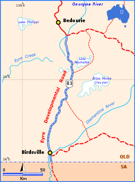
The Eyre Developmental Road is a gazetted road in south-west Queensland that runs from Bedourie to Birdsville and then to the border with South Australia, where it continues as the Birdsville Track.[1] At the northern end it joins the Diamantina Developmental Road, and the mostly unsealed road crosses the Georgina River and Diamantina River.[2] Maintenance of the road is the responsibility of the Queensland State Government.[1] The Road has no major intersections.
References
- 1 2 Queensland Government - Department of Transport and Main Roads - Maps
- ↑ Hema, Maps (2007). Australia Road and 4WD Atlas (Map). Eight Mile Plains Queensland: Hema Maps. pp. 16, 17, 18, 19. ISBN 978-1-86500-456-3.
This article is issued from
Wikipedia.
The text is licensed under Creative Commons - Attribution - Sharealike.
Additional terms may apply for the media files.