Brandon, Queensland
| Brandon Queensland | |||||||||||||||
|---|---|---|---|---|---|---|---|---|---|---|---|---|---|---|---|
 Brandon | |||||||||||||||
| Coordinates | 19°33′15″S 147°21′17″E / 19.5541°S 147.3547°ECoordinates: 19°33′15″S 147°21′17″E / 19.5541°S 147.3547°E | ||||||||||||||
| Population | 1,267 (2011 census)[1] | ||||||||||||||
| • Density | 10.756/km2 (27.857/sq mi) | ||||||||||||||
| Postcode(s) | 4808 | ||||||||||||||
| Area | 117.8 km2 (45.5 sq mi) | ||||||||||||||
| Location |
| ||||||||||||||
| LGA(s) | Shire of Burdekin | ||||||||||||||
| State electorate(s) | Burdekin | ||||||||||||||
| Federal Division(s) | Dawson | ||||||||||||||
| |||||||||||||||
Brandon is a small town and locality in the Shire of Burdekin, Queensland, Australia.[2][3] In the 2011 census, Brandon had a population of 1,267 people.[1]
Economy
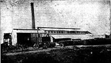
Brandon is a sugarcane growing area with underground water supplies to irrigate crops. Wilmar Sugar Australia operates two sugar mills in Brandon, the Kalamia Sugar Mill in the north-east of the locality on Lilliesmere Road beside the Lilliesmere Lagoon (19°31′22″S 147°24′59″E / 19.5229°S 147.4163°E) and the Pioneer Sugar Mill in the west of the locality on Pioneer Mill Road (19°33′30″S 147°19′51″E / 19.5583°S 147.3309°E).[4]
History
Brandon Post Office opened on 6 September 1883.[5]
Brandon Provisional School opened in the town on 9 April 1888. It became Brandon State School on 11 July 1898.[6]
Kalamia State School opened beside the Kalamia Sugar Mill on 18 July 1928.[6]
At the 2006 census, Brandon had a population of 783.[7]
Heritage listings
Brandon has a number of heritage-listed sites, including:
- 27 Spiller Street: St Patrick's Catholic Church[8]
See also
References
- 1 2 Australian Bureau of Statistics (31 October 2012). "Brandon". 2011 Census QuickStats. Retrieved 13 January 2016.

- ↑ "Brandon - town (entry 4348)". Queensland Place Names. Queensland Government. Retrieved 13 January 2016.
- ↑ "Brandon - locality (entry 44667)". Queensland Place Names. Queensland Government. Retrieved 13 January 2016.
- ↑ "Wilmar Sugar Mills - Our Mills". www.wilmarsugarmills.com. Retrieved 2015-10-27.
- ↑ Premier Postal History. "Post Office List". Premier Postal Auctions. Retrieved 10 May 2014.
- 1 2 Queensland Family History Society (2010), Queensland schools past and present (Version 1.01 ed.), Queensland Family History Society, ISBN 978-1-921171-26-0
- ↑ Australian Bureau of Statistics (25 October 2007). "Brandon (L) (Urban Centre/Locality)". 2006 Census QuickStats. Retrieved 27 April 2011.
- ↑ "St Patrick's Catholic Church (former) (entry 600372)". Queensland Heritage Register. Queensland Heritage Council. Retrieved 7 July 2013.
External links
| Wikimedia Commons has media related to Brandon, Queensland. |