Eton, Queensland
| Eton Queensland | |||||||||||||||
|---|---|---|---|---|---|---|---|---|---|---|---|---|---|---|---|
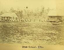
 Township of Eton, circa 1880 | |||||||||||||||
 Eton | |||||||||||||||
| Coordinates | 21°15′50″S 148°58′31″E / 21.2638°S 148.9752°ECoordinates: 21°15′50″S 148°58′31″E / 21.2638°S 148.9752°E | ||||||||||||||
| Postcode(s) | 4741 | ||||||||||||||
| Area | 105.3 km2 (40.7 sq mi) | ||||||||||||||
| LGA(s) | Mackay Region | ||||||||||||||
| State electorate(s) | Mirani | ||||||||||||||
| Federal Division(s) | Capricornia | ||||||||||||||
| |||||||||||||||
Eton is a town and a locality in the Mackay Region, Queensland, Australia.[1][2]
Geography
The northern part of the locality is flat land (about 30 metres about sea level), predominantly used as sugarcane plantations. The town is in this area. In the central part of the locality the land became hilly and is mostly used for grazing cattle. The southern part of the locality is mountainous (rising to 650 metres at Mount Bridgman) and is mostly undeveloped; some of this land is within the Ben Mohr State Forest and the Spencer Gap State Forest.[3] In the very south of the locality (21°21′16″S 148°58′20″E / 21.3545°S 148.9722°E) is the Hogan's Pocket Landfill, a waste disposal site developed in 2006 by Mackay Regional Council. The landfill gas generated from the site are captured and, although currently burned off, may be used for electricity generation in the future.[4]
The Peak Downs Highway traverses the locality from south to north-east, passing through the town. A cane tramway passes through the northern part of the locality to delivered the harvested sugarcane to local sugar mills.[3]
History

Tenders were called for the construction of Eton State School in August 1882.[5] The school opened in 20 August 1883.[6]
Education
Eton State School opened on 20 August 1883 and is a primary (P-6) school for boys and girls operated by the Queensland Government at 10 Prospect Street. [7][8] In 2016, the school had an enrolment of 50 with 3 teachers and 7 non-teaching staff (3 full-time equivalent).[9] The school celebrated its centenary in 1983.[10]
References
- ↑ "Eton - town in Mackay Region (entry 11896)". Queensland Place Names. Queensland Government. Retrieved 6 August 2017.
- ↑ "Eton - locality in Mackay Region (entry 46867)". Queensland Place Names. Queensland Government. Retrieved 6 August 2017.
- 1 2 "Queensland Globe". State of Queensland. Retrieved 8 October 2017.
- ↑ "Hogan's Pocket Landfill". Mackay Regional Council. Archived from the original on 8 October 2017. Retrieved 8 October 2017.
- ↑ "Current News". The Queenslander. XXII, (361). Queensland, Australia. 26 August 1882. p. 261. Retrieved 8 October 2017 – via National Library of Australia.
- ↑ "Opening and closing dates of Queensland Schools". Queensland Government. Retrieved 7 October 2017.
- ↑ "Opening and closing dates of schools in Queensland". Education Queensland. 1 August 2013. Retrieved 3 February 2018.
- ↑ "Eton State School". Department of Education and Training. Retrieved 3 February 2018.
- ↑ "Annual Report 2016" (PDF). Eton State School. Archived (PDF) from the original on 8 October 2017. Retrieved 8 October 2017.
- ↑ Rolleston, Frank; Rolleston, Frank, 1915- (1983), The story of: Eton State School : centenary year 1883-1983, Eton State School, retrieved 3 February 2018
Further reading
- Rolleston, Frank (1983), The story of: Eton State School : centenary year 1883-1983, Eton State School
External links
| Wikimedia Commons has media related to Eton, Queensland. |
- "Eton". Queensland Places. Centre for the Government of Queensland, University of Queensland.
- Town map of Eton, 1983