Diamantina Developmental Road
| Diamantina Developmental Road Queensland | |
|---|---|
 | |
| Diamantina Developmental Road (green on black). | |
| General information | |
| Type | Rural road |
| Length | 1,344 km (835 mi) |
| Route number(s) |
|
| Major junctions | |
| South-east end |
|
| |
| North-west end |
|
| Location(s) | |
| Major settlements | Quilpie, Windorah, Bedourie, Boulia, Dajarra |
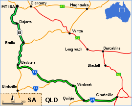
The Diamantina Developmental Road is a gazetted road entirely in Queensland, that runs from Charleville in the south-central part of the state to Mount Isa in the north-west.[1]
Route description
The road passes through the towns of Quilpie, Windorah, Bedourie, Boulia, and Dajarra in its 1344 kilometer length, and most of it is sealed.[2] Some sections between Windorah and Boulia are unsealed. The road crosses several well known rivers and creeks of the Channel Country of south-west Queensland, including the Paroo River, Bulloo River, Cooper Creek and Diamantina River.
Responsible authority
Maintenance of the road is the responsibility of the Queensland State Government.[1]
Major intersections
| LGA | Location | km | mi | Destinations | Notes |
|---|---|---|---|---|---|
| Murweh | Charleville | 0 | 0.0 | south - Cunnamulla | South-eastern end of Diamantina Developmental Road (State Route 14) |
| Quilpie | Quilpie | 197 | 122 | Quilpie Adavale Road - north - Adavale | |
| 212 | 132 | Quilpie Thargomindah Road - south - Thargomindah | |||
| 247 | 153 | Cooper Developmental Road - west - Eromanga | |||
| Quilpie / Barcoo boundary | Quilpie / Windorah boundary | 385 | 239 | Name changes to Quilpie Windorah Road | |
| Barcoo | Windorah | 450 | 280 | Thomson Developmental Road is part of a former proposed National Route 79 from Melbourne to Longreach. This route is now signed as M79/A79 from Melbourne to Mildura, then B79 to Broken Hill, beyond which there is no signed number.[3] | |
| 456 | 283 | Name reverts to Diamantina Developmental Road as it passes through Windorah CBD | |||
| 566 | 352 | Road changes to State Route 12 | |||
| Diamantina | Bedourie | 824 | 512 | Road changes to National Route 83 | |
| 847 | 526 | Name changes to Boulia Bedourie Road as it passes through Bedourie CBD | |||
| Boulia | Boulia | 1,038 | 645 | Name changes to Boulia Mount Isa Highway | |
| 1,048 | 651 | Donohue Highway - west - Queensland / Northern Territory border, where it becomes Plenty Highway (NT State Route 12) | |||
| Mount Isa | Mount Isa | 1,344 | 835 | North-western end of Diamantina Developmental Road | |
1.000 mi = 1.609 km; 1.000 km = 0.621 mi
| |||||
References
- 1 2 Queensland Government - Department of Transport and Main Roads - Maps
- ↑ Hema, Maps (2007). Australia Road and 4WD Atlas (Map). Eight Mile Plains Queensland: Hema Maps. pp. 16, 17, 18, 19. ISBN 978-1-86500-456-3.
- ↑ "National Route 79". ozroads.com.au. Retrieved 10 January 2017.
This article is issued from
Wikipedia.
The text is licensed under Creative Commons - Attribution - Sharealike.
Additional terms may apply for the media files.