Enoggera Road, Brisbane
| Enoggera Road Queensland | |
|---|---|
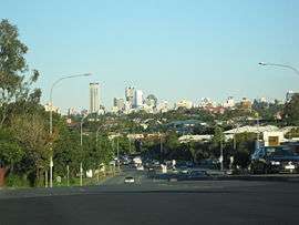 | |
| Enoggera Road at Alderley, 2008 | |
| General information | |
| Type | Road |
| Length | 2.1 km (1.3 mi) |
| Major junctions | |
| Northwest end |
|
| Southeast end |
|
| Location(s) | |
| Major suburbs | Alderley, Newmarket |
Enoggera Road is one of Brisbane's main roads which connects to the City, which is the main access road for residents of north west Brisbane. Enoggera Road is also home to the Reading Newmarket Shopping Centre, one of the first North-side Brisbane McDonald's located at Newmarket and the Newmarket public pool located at Alderley.
Major intersections
The entire road is in the Brisbane local government area.
| Location | km | mi | Destinations | Notes | |
|---|---|---|---|---|---|
| Alderley | 0 | 0.0 | South Pine Road - north (no route number) - Enoggera | Northern end of Enoggera Road (no route number) | |
| Alderley - Newmarket boundary | 0.65 | 0.40 | Alderson Street - east - Newmarket | ||
| Newmarket | 0.85 | 0.53 | Banks Street - west - Alderley | ||
| 1.4 | 0.87 | Newmarket Road - east - Wilston | |||
| 1.6 | 0.99 | Ashgrove Avenue - west - Ashgrove Edmonstone Street - east - Wilston | |||
| Newmarket - Kelvin Grove boundary | 2.1 | 1.3 | Bridge over Breakfast Creek | End of Enoggera Road. Continues south as Kelvin Grove Road. | |
| 1.000 mi = 1.609 km; 1.000 km = 0.621 mi | |||||
See also
References
Road infrastructure in Brisbane | |
|---|---|
| Freeways | |
| Highways and major roads |
|
| Arterials and other roads | |
| City streets | |
| |
Coordinates: 27°26′06.89″S 153°00′22.24″E / 27.4352472°S 153.0061778°E
This article is issued from
Wikipedia.
The text is licensed under Creative Commons - Attribution - Sharealike.
Additional terms may apply for the media files.