Thomson Developmental Road
| Thomson Developmental Road Queensland | |
|---|---|
 | |
| Thomson Developmental Road (green and black) | |
| General information | |
| Type | Rural road |
| Length | 319 km (198 mi) |
| Route number(s) |
|
| Major junctions | |
| North-east end |
|
| South-west end |
|
| Location(s) | |
| Major settlements | Jundah |
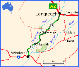
The Thomson Developmental Road is a designated sealed road in south-west Queensland running between Longreach and Windorah.[1] The length is 319 kilometres (198 mi), and it was formerly part of National Route 79 from Melbourne to Longreach.[2] Towns en-route are Stonehenge and Jundah, and the road crosses the Thomson River just west of Jundah. The road has no major intersections.
See also
References
- ↑ Queensland Government - Department of Transport and Main Roads - Maps
- ↑ Hema Maps (2007). Australia Road and 4WD Atlas (Map). Eight Mile Plains, Queensland: Hema Maps. p. 12. ISBN 978-1-86500-456-3.
This article is issued from
Wikipedia.
The text is licensed under Creative Commons - Attribution - Sharealike.
Additional terms may apply for the media files.