Calliope, Queensland
| Calliope Queensland | |||||||||||||||
|---|---|---|---|---|---|---|---|---|---|---|---|---|---|---|---|
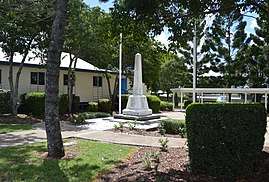 War memorial at Calliope, 2017 | |||||||||||||||
 Calliope | |||||||||||||||
| Coordinates | 24°00′22″S 151°11′56″E / 24.0061°S 151.1988°ECoordinates: 24°00′22″S 151°11′56″E / 24.0061°S 151.1988°E | ||||||||||||||
| Population | 3,058 (2011 census)[1] | ||||||||||||||
| • Density | 15.131/km2 (39.189/sq mi) | ||||||||||||||
| Established | 1871 | ||||||||||||||
| Postcode(s) | 4680 | ||||||||||||||
| Area | 202.1 km2 (78.0 sq mi) | ||||||||||||||
| Location | |||||||||||||||
| LGA(s) | Gladstone Region | ||||||||||||||
| State electorate(s) | |||||||||||||||
| Federal Division(s) | Flynn | ||||||||||||||
| |||||||||||||||
Calliope is a town and locality in the Gladstone Region, Queensland, Australia.[2][3] At the 2011 census, Calliope had a population of 3,058.[1]
Geography
Calliope is near the 'cross-roads' of the Bruce Highway and the Dawson Highway in Central Queensland, 20 kilometres (12 mi) SSW of the port city of Gladstone.
The town is reputedly named after the ship Calliope, which brought the Governor of New South Wales, Sir Charles Augustus FitzRoy to Port Curtis in 1854. Industries of the town and surrounds since that time have included gold mining, beef, timber, and more recently heavy industry (Aluminium, Coal, LNG), shipping and tourism.
History
Calliope Post Office opened on 1 March 1864.[4] Alluvial gold was mined in the area after its discovery in 1862. The following year Queensland's first goldfield was officially proclaimed. In 1872, a state primary school was opened.[5]
Local attractions
The Calliope River Historical Village is situated on the banks of the Calliope River. Lake Awoonga resulted from the construction of a dam on the Boyne River. Lake Awoonga supplies water to the city of Gladstone, and Calliope and other townships in the region, as well as supplying the major industries for which the Gladstone region is known. Total capacity of Lake Awoonga is 777,000 megalitres (203,412,500,000 gallons). The catchment area contributing to the Lake is 2,240 square kilometres (864.87 square miles) and is surrounded by the Boyne, Dawes and Many Peaks Ranges.
Lake Awoonga is home to a thriving array of native animals, several of which are of conservation significance. Two fauna species are listed as vulnerable: the yellow-bellied glider and the grey-headed flying fox. For the bird-watching enthusiast, Lake Awoonga is a paradise with more than 225 species or over 27% of Australia's bird species found in the region. The southern squatter pigeon [6] is listed as vulnerable and of conservation significance, and twenty-seven species are listed on International Migratory Conservation Agreement lists.[7] Lake Awoonga is arguably one of the most important near-coast bird refuges on the East Coast of Australia.
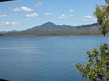
The Gladstone Area Water Board operates a fish hatchery which breeds barramundi and mangrove jack for release into Lake Awoonga. Barramundi over 20 kg (44.09 lbs) are regularly caught, and the heaviest caught by August 2008 weighed in at a hefty 36.5 kg (80.47 lbs). In addition, the mangrove jack breeding program has resulted in Lake Awoonga holding the largest stocks in Australia with over 13,000 released. Since 1996 over two and a half million barramundi fingerlings and 340,000 mullet fingerlings have been released into Lake Awoonga.[8]
Calliope has an 18-hole golf course with club and a bowls club. There are two pubs and an annual rodeo held each year. The town also has a swimming pool, racecourse, sports fields, Hazelbrook Park and a skateboard ramp.
Recent years have seen the introduction of a child care centre, supermarket shopping, specialty stores, doctors surgeries and other essential services. A large number of new homes and town houses have been built in Calliope due to its proximity to Gladstone Port and associated industries such as LNG.[9][10]
Amenities
Until 2008, Calliope was the council headquarters of the Calliope Shire which included Boyne Island, Tannum Sands, Ambrose, Mount Larcom and most of the industrial plants plus Awoonga dam. Calliope has now become one of the towns under the umbrella of the Gladstone Regional Council after the merger of the Calliope Shire Council and the former Gladstone City Council. GRC still maintain significant offices in Calliope.
The Calliope Library is on Don Cameron Drive; it is operated by the Gladstone Regional Council.[11] There is a Gladstone Regional Council administration centre at 5 Don Cameron Drive.[12]
Media: Calliope is serviced by Christian FM radio 87.6FM.
Education
Calliope State School is a government co-educational Primary (Prep to Year 6) School at Stirrat Street, Calliope.[13] In 2015 the Calliope State School had 588 students enrolled with a teaching staff of 38 FTE (Full-time equivalent) and 15 FTE non-teaching staff. Students from Calliope State School come from a wide range of socio-economic backgrounds with an ICSEA of 977 (35th percentile) in 2015. Approximately 4% of the students identify as being of Aboriginal or Torres Strait Islander descent.[14]
See also
References
- 1 2 Australian Bureau of Statistics (31 October 2012). "Calliope (Urban Centre/Locality)". 2011 Census QuickStats. Retrieved 11 July 2014.

- ↑ "Calliope - town (entry 5766)". Queensland Place Names. Queensland Government. Retrieved 27 June 2017.
- ↑ "Calliope - locality (entry 49819)". Queensland Place Names. Queensland Government. Retrieved 27 June 2017.
- ↑ Premier Postal History. "Post Office List". Premier Postal Auctions. Archived from the original on 15 May 2014. Retrieved 10 May 2014.
- ↑ "Calliope". Queensland Places. Centre for the Government of Queensland, University of Queensland. Archived from the original on 26 May 2014. Retrieved 11 July 2014.
- ↑ Dept of the Environment, Water, Heritage and the Arts' List of Threatened Fauna
- ↑ Dept of the Environment, Water, Heritage and the Arts Migratory Species in Australia Archived 27 May 2010 at the Wayback Machine.
- ↑ Gladstone Area Water Board - Official Site Archived 16 October 2006 at the Wayback Machine.
- ↑ Mayors reflect on council merger complications - ABC News (Australian Broadcasting Corporation)
- ↑ Gladstone Regional Council official site
- ↑ "Contact us". Gladstone Regional Libraries. Gladstone Regional Council. Archived from the original on 14 July 2014. Retrieved 23 June 2014.
- ↑ "Contact us". Gladstone Regional Council. Gladstone Regional Council. Archived from the original on 13 June 2014. Retrieved 23 June 2014.
- ↑ "Calliope State School". calliopess.eq.edu.au/Pages/default.aspx. Retrieved 3 February 2017.
- ↑ "Calliope State School Queensland State School Reporting 2015 School Annual Report" (PDF). Calliope State School. 2015. Archived (PDF) from the original on 3 February 2017. Retrieved 3 February 2017.
External links
![]()