Gympie
| Gympie Queensland | |||||||||||||||
|---|---|---|---|---|---|---|---|---|---|---|---|---|---|---|---|
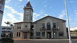 Gympie Town Hall, 2015 | |||||||||||||||
 Gympie | |||||||||||||||
| Coordinates | 26°11′24″S 152°39′56″E / 26.19°S 152.6655°ECoordinates: 26°11′24″S 152°39′56″E / 26.19°S 152.6655°E | ||||||||||||||
| Population | 20,810 (2015)[1] | ||||||||||||||
| • Density | 300.29/km2 (777.7/sq mi) | ||||||||||||||
| Established | 1867 | ||||||||||||||
| Postcode(s) | 4570 | ||||||||||||||
| Area | 69.3 km2 (26.8 sq mi)[2] (2011 urban) | ||||||||||||||
| Location | 160 km (99 mi) from Brisbane | ||||||||||||||
| LGA(s) | Gympie Region | ||||||||||||||
| State electorate(s) | Gympie | ||||||||||||||
| Federal Division(s) | Wide Bay | ||||||||||||||
| |||||||||||||||
| |||||||||||||||
Gympie /ˈɡɪmpi/[3] is a town and a locality in the Gympie Region, Queensland, Australia.[4][5] Located in the Wide Bay-Burnett district, Gympie is about 160 kilometres (100 mi) north of the state capital, Brisbane. The city lies on the Mary River, which floods the town periodically. Gympie is the administrative centre for the Gympie Region area. At June 2015 Gympie had an estimated urban population of 20,810.[1]
Gympie is famous for its gold field.[6] It contains a number of historic buildings registered on the Queensland Heritage Register.
Etymology
Gympie's name derives from the Kabi (the language of a tribe of Indigenous Australians that historically lived in the region) word gimpi-gimpi (which means "stinging tree"),[7] which referred to Dendrocnide moroides. The tree has large, round leaves that have similar properties to stinging nettles. The town was previously named Nashville, after James Nash, who discovered gold in the area in 1867.[8] The name was later changed to Gympie in 1868.[9]
History
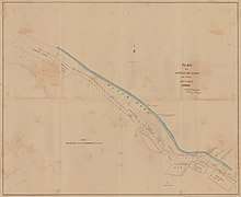
Graziers were the original European settlers. Subsequently, James Nash reported the discovery of 'payable' alluvial gold on 16 October 1867.[10] At the time of Nash's discovery, Queensland was suffering from a severe economic depression. Nash probably saved Queensland from bankruptcy. A memorial fountain in Gympie's Park honours Nash's discovery.[10] The Gympie Gold Rush Festival celebrates the event today. The Gold Rush Festival holds 10 days of cultural events in October.[11] Gold mining still plays a role in the area's fortunes, along with agriculture (dairy predominantly), timber and tourism. The gold rush's rapid development led to streets that are in an irregular fashion.[12]
Gympie Creek Post Office opened on 1 December 1867. It was renamed Gympie in 1868.[13]

The railway from Maryborough completed in 1881.[12] The North Coast railway linked Gympie to Brisbane in 1891.[12] A fire brigade was in operation in 1900. The state declared Gympie a town in 1903. A powdered milk factory began operations in 1953.

Flooding

Significant floods along the Mary River have caused inundations of the town in 1893, 1955, 1968, 1974, 1989, 1992, 1999, 2011[14] and 2013. The first recorded flood in Gympie was in 1870. Most of the floods occur between December and April and are typically caused by heavy rainfall in the headwaters to the south.[15]
The highest flood ever recorded in Gympie occurred on 2 February 1893 when the river peaked at 25.45 m.[15] Gympie was declared a natural disaster area during the 1999 floods.[16] The river peaked at 21.9 m then.
Numerous highways and roads in and around the town which were destroyed or damaged during floods in 2011 was repaired under Operation Queenslander,[17] the name given to post-flood reconstruction efforts in Queensland.
In March 2012, the Gympie Regional Council decided to spend about $30,000 for a cost benefit analysis on flood mitigation measures.[18]
Heritage listings
Gympie has a number of heritage-listed sites, including:
- Brisbane Road: Monkland State School Residence[19]
- 2 Caledonian Hill: Gympie Town Hall[20]
- Channon Street: Gympie Court House[21]
- Channon Street: Old Gympie Post Office[22]
- Channon Street: Surface Hill Uniting Church[23]
- 26 Channon Street: Gympie Lands Office[24]
- cnr Channon Street and Nash Streets: former Queensland National Bank[25]
- Church Street: St Patricks Church[26]
- 17 Crown Road: former Gympie Ambulance Station[27]
- Mary Street: Gympie and Widgee War Memorial Gates[28]
- 199 Mary Street: former Royal Bank of Queensland[29]
- 216 Mary Street: former Crawford and Co Building[30]
- 218 Mary Street: Tozer's Building[31]
- 235 Mary Street: Smithfield Chambers[32]
- 236 Mary Street: former Australian Joint Stock Bank and former Gympie Stock Exchange offices & club[33]
- 242 Mary Street: former Bank of New South Wales[34]
- 39 Nash Street: Gympie School of Arts[35]
- River Road: Gympie Memorial Park[36]
- 1 Station Road: Railway Hotel[37]
- Tozer Street: Gympie railway station[38]
Climate
| Climate data for Gympie (1870–2012) | |||||||||||||
|---|---|---|---|---|---|---|---|---|---|---|---|---|---|
| Month | Jan | Feb | Mar | Apr | May | Jun | Jul | Aug | Sep | Oct | Nov | Dec | Year |
| Record high °C (°F) | 42.4 (108.3) |
41.3 (106.3) |
38.1 (100.6) |
35.6 (96.1) |
32.8 (91) |
29.2 (84.6) |
30.2 (86.4) |
34.3 (93.7) |
38.2 (100.8) |
40.1 (104.2) |
42.2 (108) |
42.0 (107.6) |
42.4 (108.3) |
| Average high °C (°F) | 31.2 (88.2) |
30.4 (86.7) |
29.3 (84.7) |
27.3 (81.1) |
24.5 (76.1) |
22.0 (71.6) |
21.9 (71.4) |
23.3 (73.9) |
26.0 (78.8) |
28.3 (82.9) |
30.2 (86.4) |
31.3 (88.3) |
27.1 (80.8) |
| Average low °C (°F) | 19.6 (67.3) |
19.6 (67.3) |
18.1 (64.6) |
14.7 (58.5) |
10.8 (51.4) |
7.9 (46.2) |
6.2 (43.2) |
7.0 (44.6) |
10.2 (50.4) |
13.8 (56.8) |
16.4 (61.5) |
18.6 (65.5) |
13.6 (56.5) |
| Record low °C (°F) | 12.0 (53.6) |
12.3 (54.1) |
9.8 (49.6) |
3.6 (38.5) |
−0.9 (30.4) |
−3.3 (26.1) |
−4.3 (24.3) |
−1.8 (28.8) |
1.3 (34.3) |
4.6 (40.3) |
3.5 (38.3) |
10.1 (50.2) |
−4.3 (24.3) |
| Average rainfall mm (inches) | 164.8 (6.488) |
169.8 (6.685) |
144.5 (5.689) |
83.8 (3.299) |
71.6 (2.819) |
60.7 (2.39) |
52.5 (2.067) |
40.5 (1.594) |
45.4 (1.787) |
71.1 (2.799) |
88.1 (3.469) |
137.4 (5.409) |
1,130.2 (44.495) |
| Average rainy days (≥ 0.2mm) | 12.8 | 13.6 | 14.3 | 11.5 | 10.2 | 8.2 | 6.9 | 6.4 | 6.6 | 8.1 | 9.6 | 11.2 | 119.4 |
| Source: Bureau of Meteorology[39] | |||||||||||||
Attractions

Many attractions are in and around Gympie. The Gympie Gold Mining and Historical Museum houses memorabilia from the early gold mining era, as well as displays showcasing military, rural, transport, communications, and steam development in Australia. The WoodWorks Museum provides an insight into the timber industry and social history of yesteryear through displays and demonstrations. Features include a large selection of pioneering hand tools, a 1925 Republic truck, bullock wagons, and a blacksmith shop.
The Valley Rattler steam train winds its way through the backyards of the southern side of Gympie and then continues west into the scenic Mary Valley where it crosses and then follows the Mary River to negotiate the valley and the Mary's main tributaries. The tourist train began operations in 1996.[40] It provides a spectacular journey through the valley beginning at the Old Gympie Railway Station in Tozer Street. This station is the original railway station for the track that passed through Gympie in the 1900s gold rush. Unfortunately, the 'Rattler' is currently out of commission due to concerns of track safety. The local community, business, and council people are all working together to find funding for track repair work and formulate plans for the ongoing management and maintenance of the operation.
The Mary Valley has a stunning landscape of rolling green pastures and many beautiful forests. The countryside is spectacular with an abundance of curves, gradients, and bridges. Steep slopes portray a patchwork of pineapples, macadamia nuts, and other crops. The towns of the valley include Dagun, a pretty little ten-house town and Amamoor which hosts the National Country Music Muster, held annually in August. The muster is held over six days and nights in the Amamoor Forest Reserve.[41] Featuring 13 venues full of diverse music, the muster is the largest outdoor country music festival in Australia. The Mary Valley Scenic Drive also travels through Kandanga and Imbil.
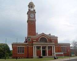
Gympie's Mary St offers a wide array of bars, cafes, banks and stores with stunning 19th Century Victorian architecture. The historic Railway Hotel was built in 1915 and is listed on the Queensland Heritage Register.[42] In 2011, the Gympie Town Hall Reserve Complex was added to the Queensland Heritage Register.[43] The two-storey building was built in 1890 and has a clock tower.
Mothar Mountain Speedway is Gympie's local raceway which hosts the motorsport Speedway A.K.A dirt track racing. Mothar Mountain Speedway is promoted by the Gympie Saloon Car Club Ltd.
Gympie also hosts the Heart of Gold International Short Film Festival in March. The festival is five days of fun, inspiration, and stimulation. Highlights include short films from all corners of the planet, special features and documentaries, parties, seminars, intimate Q & A sessions with filmmakers, and an award ceremony.
About 15 minutes south-east of Gympie, subtropical rainforest and spectacular rocky creeks make the Mothar Mountain rock pools a popular retreat for locals and visitors. Crystal-clear water gently cascades over ancient granite outcrops at Woondum National Park.[44] Facilities include picnic tables, barbecues, firewood, fresh water, amenities, and bush-walking tracks. Access is by dirt road and requires a four-wheel-drive vehicle.[45]
About 30 minutes' drive east of Gympie is Tin Can Bay, where one can hand-feed rare Indo-Pacific hump-backed dolphins in their natural environment. The feeding is regulated for the protection of the dolphins. Tin Can Bay is the southern access point to the Great Sandy Strait, a stunning aquatic playground protected by World Heritage-listed Fraser Island. The strait is an important ecological area with marine turtles, dolphin pods, dugongs, migrating humpback whales and valuable roosting area for migratory birds.
Gympie, Mary Valley, Tin Can Bay, Rainbow Beach, and Cooloola are part of the Great Sandy Biosphere which gives worldwide recognition of the outstanding natural beauty and high levels of biodiversity in this region.
The Gympie Pyramid is also a minor attraction.
Gympie Cemetery Crawls are run by the Gympie Family History Society.[46] Participants learn more about the pioneering families that created the town.
Education
Gympie has many schools, reflecting its importance as a regional service centre. State primary schools include:
- Gympie West State School opened on 28 January 1958.[47]
- Chatsworth State School opened on 18 April 1900.[48]
- Monkland State School opened on 24 September 1884.[49]
- Jones Hill State School opened on 29 January 1902.[50]
- Gympie Central State School opened on 18 October 1869.[47]
- Two Mile State School opened on 9 July 1883.[51]
- One Mile State School opened in 1869 as One Mile Boys State School with the One Mile Girls and Infants State School opening in October 1874. In January 1943, they were merged into One Mile State School.[51]
- Gympie East State School opened on 25 January 1965.[47]
- Gympie South State School [52] opened on 4 July 1910.[47]
State secondary schools include:
- James Nash State High School opened on 24 January 1977.[53][50]
- Gympie State High opened on 29 January 1912.[54] This school is one of the oldest state secondary schools in Queensland.[55]
Private schools offer both primary and secondary education. They include Victory College, Cooloola Christian College and St Patrick's.[56] St Patrick's College in Gympie opened on 30 December 1916.[57]
Gympie is home to one campus of the Wide Bay Institute of TAFE located on Cartwright Road.[58]
The University of the Sunshine Coast (USC) has a campus in Gympie located on Cartwright Road. This campus offers undergraduate study in primary education, nursing, business, and commerce.[59]
Amenities
The Gympie Regional Council operates a public library at 8-14 Mellor Street.[60] It opened in 1995.[61]
Transport
Road connection to Gympie is via the Bruce Highway. Rail connects via QR's North Coast railway line, which is served by daily Queensland Rail City network services to Brisbane and Traveltrain services for long distances. There are few public buses in Gympie and automobiles are the main mode of transportation.
Gympie Airport is a small local airport located to the south of the town. It has general aviation, recreational aviation and gliding communities.
Governance
Eight councillors are elected to the Gympie Region local government area.[62]
The Electoral district of Gympie in the state legislature was created in 1873 and includes Tin Can Bay, Rainbow Beach, Cooran, Pomona and parts of the Mary Valley.[63] In 1893, Andrew Fisher was elected to the Legislative Assembly of Queensland as Labor member for Gympie and went on to become the fifth Prime Minister of Australia.[63] Gympie's seat was eliminated in 1950 but restored in 1960.[63] Since 1960, it has been considered a safe State Liberal-National seat having been won by the Country or National Party every election except for a brief period in the early 2000s.[63] (It was held from 2002 to 2006 by Elisa Roberts, first as a member of the One Nation party and then as an independent, before returning to the National Party with the election of David Gibson.)[63]
As of 2015, Tony Perrett of the Liberal National Party in the member for Gympie in the Queensland Legislative Assembly.[64]
Traveston Crossing Dam
The Queensland Government had plans to build a dam on the Mary River at Traveston Crossing, about 16 kilometres (9.9 mi) south of Gympie, arguing that there is sound geology and that the South East Queensland region needed greater water security due to the threat of climate change and population growth.[65] The project was scrapped in 2010.
The proposed dam would have flooded about 900 properties. The affected land owners and other shire residents staged rallies protesting against the proposed dam. Strong opposition to the dam from the wider and international community based on environmental concerns related to the endangered Mary River cod, Mary River turtle, giant barred frog, Cascade tree frog and Coxen's fig parrot and the vulnerable Queensland lungfish, tusked frog, honey blue-eye fish, the Richmond birdwing butterfly and the Illidge's ant blue butterfly finally shut down the project.
Notable people
- John Francis (Frank) Barnes – politician
- John O'Connell Bligh – Native Police Commandant
- Allan Boase – Australian Army Lieutenant General[66]
- Henry Ernest Boote – writer
- Glen Boss – jockey[67]
- Archie Bradley – boxer
- Jimmy Downey – football player
- Thomas Dunstan – politician[68]
- Hugo William Du Rietz – gold miner, architect
- Andrew Fisher – Australian Prime Minister[69]
- Sir Thomas William Glasgow – Australian Army Major General
- Kaden Groves - professional cyclist
- Darren Hanlon – musician
- Peter Hanlon – sports writer
- Kenneth Hayne – Supreme Court Justice
- Trevor Housley – Postmaster-General
- Angus Finlay Hutton – naturalist
- Thelma Keane – businesswoman
- James Kidgell – politician
- Tracey Lewis – paralympic swimmer
- George Mackay – politician
- Barry McTaggart – rugby player
- Mathew Mellor – politician
- James Nash – prospector
- Francis Isidore Power – politician
- Gregory Charles Rivers – actor
- Marjorie Roche – Red Cross nurse
- Christopher Scott – paralympic cyclist[70]
- Sir Christopher Sheehy – dairy industry administrator
- Ann Caroline Sherry AO – businesswoman
- Jacob Stumm – newspaper owner
- Harry Sunderland – rugby administrator[71]
- Estelle Thompson – crime novelist
- Vivian Tozer – politician
- The Amity Affliction – musicians
See also
- The Gympie Times, a current newspaper
- The Gympie Miner, a former newspaper
- Gympie Cemetery
References
- 1 2 "3218.0 – Regional Population Growth, Australia, 2014–15: Population Estimates by Significant Urban Area, 2005 to 2015". Australian Bureau of Statistics. Australian Bureau of Statistics. 30 March 2016. Archived from the original on 8 September 2016. Retrieved 12 September 2016. Estimated resident population, 30 June 2015.
- ↑ "2011 Census Community Profiles: Gympie". ABS Census. Australian Bureau of Statistics. Archived from the original on 19 April 2018. Retrieved 15 September 2016.
- ↑ Macquarie Dictionary, Fourth Edition (2005). Melbourne, The Macquarie Library Pty Ltd. ISBN 1-876429-14-3
- ↑ "Gympie - town in Gympie Region (entry 15149)". Queensland Place Names. Queensland Government. Retrieved 6 November 2017.
- ↑ "Gympie - locality in Gympie Region (entry 46339)". Queensland Place Names. Queensland Government. Retrieved 6 November 2017.
- ↑ Khan, M. Ali; A.Balakishan (2007). Encyclopedia of World Geography. Sarup & Sons. p. 45. ISBN 8176257737. Retrieved 20 May 2012.
- ↑ "History". Gympie Regional Council. Archived from the original on 17 March 2012. Retrieved 20 May 2012.
- ↑ Hon. C. Wallace, Gympie residents have chance to make their mark on the map Archived 16 July 2011 at the Wayback Machine., 14 January 2008. Accessed 18 April 2009.
- ↑ Unidentified (1955). "Gympie Fire Station in 1955". John Oxley Library, State Library of Queensland. Retrieved 20 April 2018.
- 1 2 Stoodley, June. Nash, James (1834–1913) Archived 9 May 2012 at Wikiwix. Australian Dictionary of Biography, National Centre of Biography. Australian National University.
- ↑ "Gold Rush Festival - Gympie Goldrush". goldrush.org.au. Retrieved 19 April 2018.
- 1 2 3 Environmental Protection Agency (2000). Heritage Trails of the Great South East. State of Queensland. pp. 90, 148. ISBN 0-7345-1008-X.
- ↑ Premier Postal History. "Post Office List". Premier Postal Auctions. Archived from the original on 15 May 2014. Retrieved 10 May 2014.
- ↑ "Flood Warning System For The Mary River". Bureau of Meteorology. Retrieved 6 May 2012.
- 1 2 Jannette Parke (6 March 2010). "Mary, Mary quite contrary". The Gympie Times. Archived from the original on 11 March 2010. Retrieved 6 May 2012.
- ↑ "Qld flood crisis hits Gympie". weeklytimes.now.com.au. The Weekly Times. 10 January 2011. Archived from the original on 8 May 2012. Retrieved 6 May 2012.
- ↑ "Road flood repairs on-going". The Gympie Times. 7 May 2012. Archived from the original on 18 May 2012. Retrieved 20 May 2012.
- ↑ "Staying afloat". Sunshine Coast Daily. Sunshine Coast Newspaper Company. 9 March 2012. Retrieved 6 May 2012.
- ↑ "Monkland State School Residence (entry 602013)". Queensland Heritage Register. Queensland Heritage Council. Retrieved 8 July 2013.
- ↑ "Gympie Town Hall Reserve Complex (entry 602789)". Queensland Heritage Register. Queensland Heritage Council. Retrieved 8 July 2013.
- ↑ "Gympie Court House (entry 600533)". Queensland Heritage Register. Queensland Heritage Council. Retrieved 8 July 2013.
- ↑ "My Country; Old Post Office (entry 600534)". Queensland Heritage Register. Queensland Heritage Council. Retrieved 8 July 2013.
- ↑ "Surface Hill Uniting Church (entry 601529)". Queensland Heritage Register. Queensland Heritage Council. Retrieved 8 July 2013.
- ↑ "Gympie Court House and Lands Office (former) (entry 602778)". Queensland Heritage Register. Queensland Heritage Council. Retrieved 8 July 2013.
- ↑ "Queensland National Bank (former) (entry 602773)". Queensland Heritage Register. Queensland Heritage Council. Retrieved 8 July 2013.
- ↑ "St Patricks Church (entry 601503)". Queensland Heritage Register. Queensland Heritage Council. Retrieved 8 July 2013.
- ↑ "Gympie Ambulance Station (former) (entry 602794)". Queensland Heritage Register. Queensland Heritage Council. Retrieved 8 July 2013.
- ↑ "Gympie and Widgee War Memorial Gates (entry 600535)". Queensland Heritage Register. Queensland Heritage Council. Retrieved 8 July 2013.
- ↑ "Royal Bank of Queensland (former) (entry 602774)". Queensland Heritage Register. Queensland Heritage Council. Retrieved 8 July 2013.
- ↑ "Crawford and Co. Building (former) (entry 602780)". Queensland Heritage Register. Queensland Heritage Council. Retrieved 8 July 2013.
- ↑ "Tozer's Building (entry 602779)". Queensland Heritage Register. Queensland Heritage Council. Retrieved 8 July 2013.
- ↑ "Smithfield Chambers (entry 602777)". Queensland Heritage Register. Queensland Heritage Council. Retrieved 8 July 2013.
- ↑ "Australian Joint Stock Bank (former)/Gympie Stock Exchange Offices and Club (former) (entry 602772)". Queensland Heritage Register. Queensland Heritage Council. Retrieved 8 July 2013.
- ↑ "Bank of New South Wales (former) (entry 602775)". Queensland Heritage Register. Queensland Heritage Council. Retrieved 8 July 2013.
- ↑ "Gympie School of Arts (entry 601910)". Queensland Heritage Register. Queensland Heritage Council. Retrieved 8 July 2013.
- ↑ "Memorial Park (entry 602729)". Queensland Heritage Register. Queensland Heritage Council. Retrieved 8 July 2013.
- ↑ "Railway Hotel (entry 602540)". Queensland Heritage Register. Queensland Heritage Council. Retrieved 8 July 2013.
- ↑ "Gympie Railway Station Platform Complex (entry 602036)". Queensland Heritage Register. Queensland Heritage Council. Retrieved 8 July 2013.
- ↑ "Gympie". Climate statistics for Australian locations. Bureau of Meteorology. March 2013. Retrieved 23 March 2013.
- ↑ "Mary Valley". Queensland Places. Centre for the Government of Queensland, University of Queensland. Archived from the original on 25 October 2012. Retrieved 20 May 2012.
- ↑ "Amamoor State Forest and Forest Reserve – Camping information". Department of Environment and Resource Management. 14 October 2011. Archived from the original on 9 May 2012. Retrieved 20 May 2012.
- ↑ Lee Gailer (17 January 2012). "Piece of history goes on the block". The Gympie Times. Archived from the original on 2 February 2012. Retrieved 6 May 2012.
- ↑ "State heritage listing for Gympie icon". Queensland Heritage Council. 9 September 2012. Archived from the original on 29 March 2013. Retrieved 21 May 2012.
- ↑ "Woondum National Park". Department of Environment and Resource Management. 9 June 2011. Archived from the original on 5 May 2012. Retrieved 21 May 2012.
- ↑ Alexia Purcell (24 March 2010). "Trip to Mothar Mountain rock pools". Sunshine Coast Daily. Sunshine Coast Newspaper Company. Retrieved 21 May 2012.
- ↑ "Cemetery Crawls". Gympie Family History Society Inc. Archived from the original on 29 February 2016. Retrieved 19 March 2016.
- 1 2 3 4 "Opening and closing dates of Queensland schools (G)". education.qld.gov.au. Archived from the original on 22 September 2017. Retrieved 29 January 2018.
- ↑ "Opening and closing dates of Queensland schools (C)". education.qld.gov.au. Archived from the original on 7 November 2017. Retrieved 29 January 2018.
- ↑ "Opening and closing dates of Queensland schools (M)". education.qld.gov.au. Archived from the original on 17 January 2018. Retrieved 29 January 2018.
- 1 2 "Opening and closing dates of Queensland schools (J)". education.qld.gov.au. Archived from the original on 11 August 2017. Retrieved 29 January 2018.
- 1 2 Queensland Family History Society (2010), Queensland schools past and present (Version 1.01 ed.), Queensland Family History Society, ISBN 978-1-921171-26-0
- ↑ "School opening dates". Archived from the original on 9 August 2017. Retrieved 29 January 2017.
- ↑ "James Nash SHS". Archived from the original on 2 February 2017. Retrieved 29 January 2017.
- ↑ "Gympie SHS". Archived from the original on 4 February 2017. Retrieved 29 January 2017.
- ↑ "The oldest state secondary schools in Queensland". education.qld.gov.au. Archived from the original on 29 January 2018. Retrieved 29 January 2018.
- ↑ "Gympie Regional Council – Schools". Archived from the original on 18 May 2009. Retrieved 19 April 2018.
- ↑ "Opening and closing dates of Queensland schools". Education Queensland. 3 February 2014. Archived from the original on 20 February 2017. Retrieved 3 February 2018.
- ↑ "Gympie". Wide Bay Institute of TAFE. Archived from the original on 20 March 2012. Retrieved 20 May 2012.
- ↑ "USC Gympie". www.usc.edu.au. Archived from the original on 3 August 2017. Retrieved 19 April 2018.
- ↑ "Library locations". Gympie Regional Council. Archived from the original on 31 January 2018. Retrieved 31 January 2018.
- ↑ "Public Libraries Statistical Bulletin 2016-17" (PDF). Public Libraries Connect. State Library of Queensland. November 2017. p. 13. Archived (PDF) from the original on 30 January 2018. Retrieved 30 January 2018.
- ↑ Carly Morrissey (14 May 2012). "Ready for council? My oath". The Gympie Times. Retrieved 20 May 2012.
- 1 2 3 4 5 "Latest on elections with The Times". The Gympie Times. 3 March 2012. Retrieved 21 May 2012.
- ↑ Green, Antony. "Gympie". Queensland Election 2015. Australian Broadcasting Corporation.
- ↑ Josephine Gillespie (26 March 2008). "Plan promises no more water woes". The Queensland Times. APN News & Media. Archived from the original on 22 June 2010. Retrieved 19 December 2010.
- ↑ Dicker, George. "Boase, Allan Joseph (1894–1964)". Australian Dictionary of Biography. Australian National University. Archived from the original on 30 September 2017. Retrieved 29 September 2017.
- ↑ "Glen Boss Australian Champion Jockey". ProGroup Racing. Archived from the original on 9 March 2013. Retrieved 28 April 2017.
- ↑ "Former Members". Parliament of Queensland. 2015. Archived from the original on 6 May 2016. Retrieved 15 April 2016.
- ↑ "Andrew Fisher". Wikipedia. 24 April 2017.
- ↑ – cyclist"Australians at the 1996 Atlanta Paralympics: Cyclists". Australian Sports Commission. Archived from the original on 20 January 2000. Retrieved 15 January 2012.
- ↑ Edmond, Scott (2002). "Australian Dictionary Of Biography". Sunderland, Harry (1889–1964). Australian Dictionary of Biography. Archived from the original on 30 March 2015. Retrieved 30 March 2015.
External links
| Wikimedia Commons has media related to Gympie, Queensland. |