Carmila, Queensland
| Carmila Queensland | |||||||||||||||
|---|---|---|---|---|---|---|---|---|---|---|---|---|---|---|---|
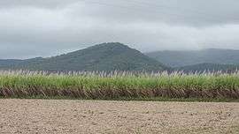 View across sugar cane fields towards the mountains, Carmila, 2016 | |||||||||||||||
 Carmila | |||||||||||||||
| Coordinates | 21°55′S 149°25′E / 21.917°S 149.417°ECoordinates: 21°55′S 149°25′E / 21.917°S 149.417°E | ||||||||||||||
| Population | 398 (2011 census)[1] | ||||||||||||||
| Postcode(s) | 4739 | ||||||||||||||
| Location |
| ||||||||||||||
| LGA(s) | Isaac Region | ||||||||||||||
| State electorate(s) | Mirani | ||||||||||||||
| Federal Division(s) | Capricornia | ||||||||||||||
| |||||||||||||||
Carmila is a coastal town and locality in the Isaac Region, Queensland, Australia.[2][3] At the 2011 census, Carmila and the surrounding area had a population of 398.[1]
Geography
Carmila is situated approximately 65 kilometres (40 mi) south of the town of Sarina. The North Coast railway line passes through the town which is served by the Carmila railway station. The Bruce Highway passes through the town as well. A large portion of the north west of Carmila belongs to the West Hill State Forest. Along the coast, the West Hill National Park was established in 1971.[4] The major land uses are sugar cane farming and cattle grazing. Professional fishing occurs off the coast.[5]
History
Carmila State School opened on 9 July 1923.[6]
Carmila Post Office opened by March 1924 (a receiving office had been open from 1894).[7]
Carmila West State School opened on 18 August 1924 and closed on 31 December 1965.[6]
Carmila Police Station opened in 1933.[5]
The Carmila Library opened in 1978.[8]
Heritage listings
Carmila has a number of heritage-listed sites, including the Carmila Cane Lift at 49 Hindles Road.[9]
Amenities
The Isaac Regional Council operates a public library at 16 Music Street.[10]
Education
Camila State School is a government co-education primary (P-6) school. In 2014, it had 32 students enrolled with 2 teachers (2 full-time equivalent).[11] The nearest secondary school is in Sarina.[12]
References
- 1 2 Australian Bureau of Statistics (31 October 2012). "Carmila (State Suburb)". 2011 Census QuickStats. Retrieved 14 June 2015.

- ↑ "Carmila - town in the Isaac Region (entry 6279)". Queensland Place Names. Queensland Government. Retrieved 28 September 2017.
- ↑ "Carmila - locality in Isaac Region (entry 49756)". Queensland Place Names. Queensland Government. Retrieved 28 September 2017.
- ↑ "Queensland Globe". State of Queensland. Retrieved 29 July 2016.
- 1 2 "Camila Police Station" (PDF). Queensland Police Service. Retrieved 29 July 2016.
- 1 2 "Opening and closing dates of Queensland Schools". Queensland Government. Retrieved 29 December 2015.
- ↑ Premier Postal History. "Post Office List". Premier Postal Auctions. Retrieved 10 May 2014.
- ↑ "Public Libraries Statistical Bulletin 2016-2017" (PDF). Public Libraries Connect. State Library of Queensland. November 2017. p. 13. Retrieved 21 January 2018.
- ↑ "Carmila Cane Lift (entry 602751)". Queensland Heritage Register. Queensland Heritage Council. Retrieved 10 July 2013.
- ↑ "Carmila Library". Public Libraries Connect. State Library of Queensland. 21 June 2017. Retrieved 21 January 2018.
- ↑ "2014 Annual Report" (PDF). Carmila State School. Retrieved 29 December 2015.
- ↑ "Queensland Globe". State of Queensland. Retrieved 16 October 2018.
Further reading
- Carmila State School (Qld.) (1973), Golden jubilee celebration, 1923-1973, Carmila State School : souvenir booklet, Carmila State School, ISBN 978-0-9598337-0-6
External links
| Wikimedia Commons has media related to Carmila, Queensland. |
- "Carmila". Isaac Regional Council. Retrieved 23 March 2009.