Glass House Mountains
| Glass House Mountains | |
|---|---|
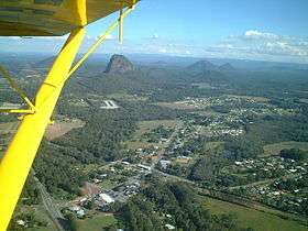 Aerial photo of Glass House Mountains township with the Glass House Mountains in the distance | |
| Highest point | |
| Peak | Mount Beerwah |
| Elevation | 556 m (1,824 ft) |
| Coordinates | 26°54′S 152°55′E / 26.900°S 152.917°ECoordinates: 26°54′S 152°55′E / 26.900°S 152.917°E |
| Geography | |
 Glass House Mountains | |
| Country | Australia |
| State | Queensland |
| Region | South East Queensland |
| Geology | |
| Formed by | Volcanic plugs |
| Age of rock | Tertiary |
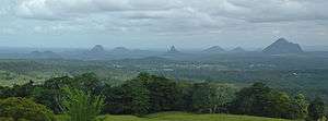
The Glass House Mountains are a group of thirteen hills that rise abruptly from the coastal plain on the Sunshine Coast, Queensland, Australia. The highest hill is Mount Beerwah at 556 metres above sea level, but the most identifiable of all the hills is Mount Tibrogargan which from certain angles bears a resemblance to a face staring east towards the ocean. The Glass House Mountains are located near Beerburrum State Forest and Steve Irwin Way. From Brisbane, the mountains can be reached by following the Bruce Highway north and taking the Glass House Mountains tourist drive turn-off onto Steve Irwin Way. The trip is about one hour from Brisbane. The Volcanic peaks of the Glass House Mountains rise dramatically from the surrounding Sunshine Coast landscape. They were formed by intrusive plugs, remnants of volcanic activity that occurred 26-27 million years ago[1]. Molten rock filled small vents or intruded as bodies beneath the surface and solidified into land rocks. Millions of years of erosion have removed the surrounding exteriors of volcanic cores and softer sandstone rock.
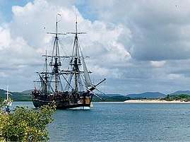
Whilst the traditional names for the hills themselves are very old, the term 'Glasshouse Mountains' was given more recently by explorer Captain James Cook on 17 May 1770.[2] The peaks reminded him of the glass furnaces in his home county of Yorkshire.[3] Matthew Flinders explored the area and climbed Mount Beerburrum after sailing along Pumicestone Passage in 1799. The Glass House Mountains National Landscape was added to the Australian National Heritage List on 3 August 2006.[4] In the land between the peaks, pineapple and poultry farming, as well as commercial forestry and quarrying are the main land uses.[5]
In 2009 as part of the Q150 celebrations, the Glass House Mountains was announced as one of the Q150 Icons of Queensland for its role as a "Natural attraction".[6]
Geology
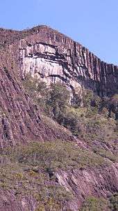
The range was formed as molten lava cooled to form hard rock in the cores of volcanoes 26-27 million years ago[1]. The source of the lava was from the East Australia hotspot. The cores of the hills contain columns of comendite from lava which cools quickly into a hard rock.[7] The surrounding softer rocks have been eroded in the subsequent time, forming the spectacular volcanic plugs that remain today.[3] The peaks' location relative to each other exhibits an alignment that is believed to have occurred due to fracturing.[5] Mt Ngungun consists of sub-volcanic rock, also known as a hypabyssal rock, an intrusive rock emplaced at medium-to-shallow depths within the crust and has intermediate grain size, and often porphyritic texture between that of volcanic and plutonic rocks.
Peaks
Each of the peaks is protected within the Glass House Mountains National Park. Some of the peaks display vertical columns, particularly Mount Coonowrin, Mount Ngungun and Mount Beerwah at the Organ Pipes.[5] These columns are the result of lava contraction. Scattered throughout the hills are shallow caves which have been formed by wind erosion on rocks that were softened by groundwater.[5] The peaks are culturally significant to the traditional owners, the Gubbi Gubbi people. Under a native title claim, access to the peaks could be restricted as they are considered spiritual places.[3] To the south east of the Glass House Mountains township is an Aboriginal bora ring.[5] The names of each mountain in the range are:
|
|
|
.
Aboriginal legend
The Glass House Mountains are located in the traditional lands of the Jinibara[8] and Gubbi Gubbi people. The mountains are members of a family with the father being Mount Tibrogargan and the mother Mount Beerwah. All of the other mountains are sons and daughters with the eldest being Mount Coonowrin, the twins called Tunbubudla, Miketeebumulgrai, Elimbah whose shoulders were bent because she carried many cares, Round because she was so small and fat and Wild Horse who always strayed away from the others to swim in the sea.[9]
Tibrogargan, the father, observes that the sea is rising and asks that Coonowrin the eldest son help their pregnant mother to safety. Terrified, Coonowrin instead flees. Infuriated by his son's cowardliness, Tibrogargan pursues him and strikes him with his nulla nulla so hard that he dislocates Coonowrin's neck.[9]
Once the danger passes Coonowrin feels tremendous guilt for his actions and asks his father, brothers and sisters for forgiveness but they all weep with shame. This is said to explain the many small streams that flow through the area. Tibrogargan turns his back on Coonowrin and gazes out to sea refusing to look at his son Coonowrin who continues to hang his head in shame and weeps.[9]
Public access
The mountains are managed by Queensland National Parks and are promoted as a tourist asset. Historically bushwalking and climbing has been undertaken for more than a century. However the two largest mountains have been closed by National Parks in recent years. Firstly, Coonowrin was closed in 1999 as a result of a geological report and the development of an adjacent rock quarry. Secondly, the walking track used to access Mt Beerwah was closed in 2009 as the result of a rock collapse from the caves area across the main tourist track and was reopened January 2016. Tibrogargan and Ngungun are open to the public for bushwalking and climbing.
Flora and Fauna
There are many different types of plants including trees, grass, bushes and the occasional shrub. Animals that live there include birds, reptiles, frogs, bats, rats, cats and mammals. The Elf Skink, a small lizard, also populates the area. [10]
See also
References
- 1 2 Cohen, B. E.; Vasconcelos, P. M.; Knesel, K. M. (1 February 2007). "40Ar/39Ar constraints on the timing of Oligocene intraplate volcanism in southeast Queensland". Australian Journal of Earth Sciences. 54 (1): 105–125. doi:10.1080/08120090600981483. ISSN 0812-0099.
- ↑ ""Flashback", page 6, Brisbane News — May 11-17, 2011". Archived from the original on 16 March 2017. Retrieved 19 March 2018.
- 1 2 3 Environmental Protection Agency (Queensland) (2000). Heritage Trails of the Great South East. State of Queensland. p. 127. ISBN 0-7345-1008-X.
- ↑ "National Heritage Places - Glass House Mountains National Landscape". Commonwealth of Australia. Archived from the original on 28 December 2014. Retrieved 29 November 2014.
- 1 2 3 4 5 Shilton, Peter (2005). Natural Areas of Queensland. Mount Gravatt, Queensland: Goldpress. pp. 160–162. ISBN 0-9758275-0-2.
- ↑ Bligh, Anna (10 June 2009). "PREMIER UNVEILS QUEENSLAND'S 150 ICONS". Queensland Government. Archived from the original on 24 May 2017. Retrieved 24 May 2017.
- ↑ Willmott, Warwick (2004). Rocks and Landscapes of the National Parks of Southern Queensland. Brisbane, Queensland: Geological Society of Australia, Queensland Division. p. 162. ISBN 1-876125-46-2.
- ↑ QSNTS Website for Native Title claim area Jinibara https://web.archive.org/web/20150526053943/http://qsnts.com.au/index.cfm?contentID=69. Archived from the original on 26 May 2015. Missing or empty
|title=(help) - 1 2 3 "Glasshouse Aboriginal Legend". www.coolrunning.com.au. Retrieved 3 October 2018.
- ↑ "Elf skink (Eroticoscincus graciloides) at the Australian Reptile Online Database - AROD.com.au". www.arod.com.au. Archived from the original on 10 January 2018. Retrieved 19 March 2018.
External links
| Wikimedia Commons has media related to Glass House Mountains National Park. |