Leichhardt Highway
| Leichhardt Highway Queensland | |
|---|---|
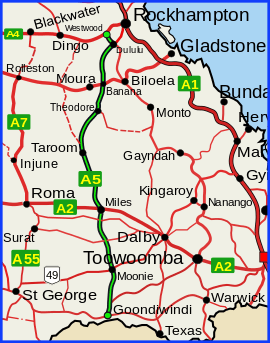 | |
| Leichhardt Highway (green on black) | |
| General information | |
| Type | Highway |
| Length | 613 km (381 mi) |
| Route number(s) |
|
| Former route number |
|
| Major junctions | |
| South end |
|
| |
| North end |
|
| Location(s) | |
| Major settlements | Moonie, Miles, Guluguba, Wandoan, Taroom, Theodore, Banana, Dululu |
| Highway system | |
The Leichhardt Highway is a major transport route in Queensland, Australia. It is a continuation northward from Goondiwindi of the Newell Highway.[1]
It runs northward from Goondiwindi for more than 600 kilometres until its termination at the Capricorn Highway near the small town of Westwood.[2]
It is named after Prussian explorer Ludwig Leichhardt who travelled a route in the 19th Century that roughly parallels today's highway.
List of towns along the Leichhardt Highway
Travelling from south to north:
Major intersections
| LGA | Location | km | mi | Destinations | Notes |
|---|---|---|---|---|---|
| Goondiwindi | Goondiwindi | 0 | 0.0 | Marshall Street - west - Goondiwindi CBD | Southern end of Leichhardt Highway Runs north as State Highway A5 |
| 2.0 | 1.2 | Leichhardt Highway turns west as Boundary Road | |||
| 6.0 | 3.7 | Leichhardt Highway turns north | |||
| 21.0 | 13.0 | ||||
| Western Downs | Moonie | 99.3 | 61.7 | south-west - St George | |
| The Gums | 146 | 91 | west - Surat | ||
| Condamine | 191 | 119 | |||
| Miles | 227 | 141 | west - Roma | South-eastern concurrency terminus with Warrego Highway | |
| 228 | 142 | North-western concurrency terminus with Warrego Highway | |||
| Banana | Taroom | 374 | 232 | ||
| Theodore | 451 | 280 | |||
| Banana | 508 | 316 | north - Banana CBD | Southern concurrency terminus with Dawson Highway | |
| 509 | 316 | Northern concurrency terminus with Dawson Highway | |||
| Dululu | 588 | 365 | south-east - Jambin | ||
| Westwood | 613 | 381 | south-west - Duaringa | Northern end of Leichhardt Highway | |
1.000 mi = 1.609 km; 1.000 km = 0.621 mi
| |||||
Gallery
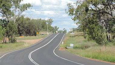 Leichhardt Highway, looking south from Guluguba Cafe, 2014
See also
References
- ↑ Queensland Government - Department of Transport and Main Roads - Maps
- ↑ Hema, Maps (2007). Australia Road and 4WD Atlas (Map). Eight Mile Plains Queensland: Hema Maps. pp. 8/11. ISBN 978-1-86500-456-3.
This article is issued from
Wikipedia.
The text is licensed under Creative Commons - Attribution - Sharealike.
Additional terms may apply for the media files.