Brownsburg Historic District
|
Brownsburg Historic District | |
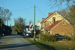 Entering the community from the south | |
  | |
| Location | Including the entire village extending 0.5 miles along State Route 252, Brownsburg, Virginia |
|---|---|
| Coordinates | 37°55′43″N 79°19′09″W / 37.92861°N 79.31917°WCoordinates: 37°55′43″N 79°19′09″W / 37.92861°N 79.31917°W |
| Area | 100 acres (40 ha) |
| Built | 1825 |
| Architectural style | Federal, Valley Federal |
| NRHP reference # | 73002055[1] |
| VLR # | 081-0121 |
| Significant dates | |
| Added to NRHP | July 2, 1973 |
| Designated VLR | February 20, 1973[2] |
Brownsburg Historic District is a national historic district located at Brownsburg, Rockbridge County, Virginia. The district encompasses 42 contributing buildings in the town of Brownsburg. It includes a variety of residential, commercial, and institutional buildings most of which date from one of two periods - the first half of the 19th century and the period 1870-1910. Notable buildings include the Swope House, Wade brick house, Bosworth log house, Newcomer house, Coblentz house and store, NYE Pool Hall, Wade frame house, Ward House, and the Fixx House.[3]
It was listed on the National Register of Historic Places in 1973.[1]
References
- 1 2 National Park Service (2010-07-09). "National Register Information System". National Register of Historic Places. National Park Service.
- ↑ "Virginia Landmarks Register". Virginia Department of Historic Resources. Retrieved 5 June 2013.
- ↑ Virginia Historic Landmarks Commission Staff (December 1972). "National Register of Historic Places Inventory/Nomination: Brownsburg Historic District" (PDF). Virginia Department of Historic Resources. and Accompanying photo and Accompanying map Archived October 4, 2013, at the Wayback Machine.


This article is issued from
Wikipedia.
The text is licensed under Creative Commons - Attribution - Sharealike.
Additional terms may apply for the media files.