Harqin Zuoyi Mongol Autonomous County
| Harqin Zuoyi County ᠬᠠᠷᠠᠴᠢᠨ ᠵᠡᠭᠦᠨ ᠭᠠᠷᠤᠨ ᠰᠢᠶᠠᠨ 喀喇沁左翼县 | |
|---|---|
| Autonomous county | |
|
ᠬᠠᠷᠠᠴᠢᠨ ᠵᠡᠭᠦᠨ ᠭᠠᠷᠤᠨ ᠮᠣᠩᠭᠣᠯ ᠥᠪᠡᠷᠲᠡᠭᠡᠨ ᠵᠠᠰᠠᠬᠤ ᠰᠢᠶᠠᠨ 喀喇沁左翼蒙古族自治县 Harqin Left Mongol Autonomous County | |
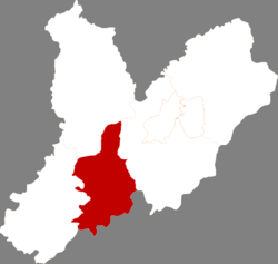 Location in Chaoyang City | |
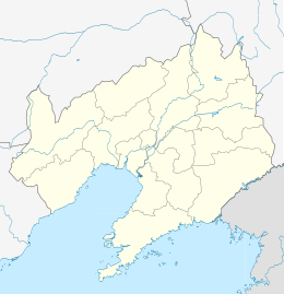 Harqin Location in Liaoning | |
| Coordinates: 41°08′N 119°44′E / 41.133°N 119.733°E | |
| Country | People's Republic of China |
| Province | Liaoning |
| Prefecture-level city | Chaoyang |
| County seat | Dachengzi (大城子镇) |
| Area | |
| • Total | 2,240 km2 (860 sq mi) |
| Elevation | 327 m (1,073 ft) |
| Population | |
| • Total | 420,000 |
| • Density | 190/km2 (490/sq mi) |
| Time zone | UTC+8 (China Standard) |
| Postal code | 122300 |
Harqin Zuoyi Mongol Autonomous County (simplified Chinese: 喀喇沁左翼蒙古族自治县; traditional Chinese: 喀喇沁左翼蒙古族自治縣; pinyin: Kālǎqìn Zuǒyì Měnggǔzú Zìzhìxiàn), commonly abbreviated as Kazuo County (喀左县), is a Mongolian autonomous county in the west of Liaoning province, China. It is under the administration of Chaoyang City, 77 km (48 mi) to the northeast, and has a population of 420,000 residing in an area of 2,240 km2 (860 sq mi). Formerly known as, Harqin Left Banner.
Administrative divisions
There are 11 towns and 11 townships in the county.[1]
|
Towns:
|
Townships:
|
References
- ↑ 2011年统计用区划代码和城乡划分代码:喀喇沁左翼蒙古族自治县 (in Chinese). National Bureau of Statistics of the People's Republic of China. Retrieved 2012-07-17.
External links
| Regions |
|  | |||||||
|---|---|---|---|---|---|---|---|---|---|
| Prefectures and counties |
| ||||||||
| |||||||||
This article is issued from
Wikipedia.
The text is licensed under Creative Commons - Attribution - Sharealike.
Additional terms may apply for the media files.