Gildeskål
| Gildeskål kommune | |||
|---|---|---|---|
| Municipality | |||
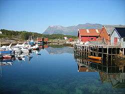 View of Inndyr | |||
| |||
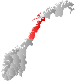
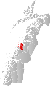 Gildeskål within Nordland | |||
| Coordinates: 67°01′24″N 14°04′38″E / 67.02333°N 14.07722°ECoordinates: 67°01′24″N 14°04′38″E / 67.02333°N 14.07722°E | |||
| Country | Norway | ||
| County | Nordland | ||
| District | Salten | ||
| Established | 1838 | ||
| Administrative centre | Inndyr | ||
| Government | |||
| • Mayor (2011) | Petter Jørgen Pedersen (Ap) | ||
| Area | |||
| • Total | 664.68 km2 (256.63 sq mi) | ||
| • Land | 622.27 km2 (240.26 sq mi) | ||
| • Water | 42.41 km2 (16.37 sq mi) | ||
| Area rank | #170 in Norway | ||
| Population (2017) | |||
| • Total | 2,024 | ||
| • Rank | #328 in Norway | ||
| • Density | 3.3/km2 (9/sq mi) | ||
| • Change (10 years) | -2.7% | ||
| Demonym(s) |
Gildeskålfjerding Gildeskålværing[1] | ||
| Time zone | UTC+01:00 (CET) | ||
| • Summer (DST) | UTC+02:00 (CEST) | ||
| ISO 3166 code | NO-1838 | ||
| Official language form | Neutral | ||
| Website |
gildeskal | ||
Gildeskål is a municipality in Nordland county, Norway. It is part of the Bodø Region and the traditional district of Salten. The administrative centre of the municipality is the village of Inndyr. Other villages include Forstranda, Lekanger, Mevik, Mårnes, Nygårdsjøen, Saura, Storvika, Sørarnøya, Sørfinnset, and Våg.
The 665-square-kilometre (257 sq mi) municipality is the 170th largest by area out of the 422 municipalities in Norway. Gildeskål is the 328th most populous municipality in Norway with a population of 2,024. The municipality's population density is 3.3 inhabitants per square kilometre (8.5/sq mi) and its population has decreased by 2.7% over the last decade.[2]
General information

The municipality of Gildeskaal (later spelled Gildeskål) was established as a municipality on 1 January 1838 (see formannskapsdistrikt).
In 1853, the eastern district of Gildeskaal (population: about 1,150) was separated to become the new municipality of Beiarn. This left Gildeskaal with about 2,400 residents. The municipal boundaries have not changed since.[3]
Name
The municipality (originally the parish) is named after the old Gildeskaal farm (Old Norse: Gildaskáli) because the first church was built there (Old Gildeskål Church. The first element is the plural genitive case of gildi 'feast' or 'banquet', and the last element is skáli 'hall'.[4][5]
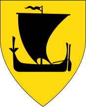
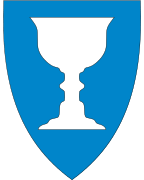
Coat-of-arms
The coat-of-arms is from modern times (1988). The arms show a silver cup on a blue background. The arms are canting since the meaning of the name Gildeskål refers to a banquet hall.[5]
- See also: Coat-of-arms of Jevnaker.
Churches
The Church of Norway has one parish (sokn) within the municipality of Gildeskål. It is part of the Bodø domprosti (arch-deanery) in the Diocese of Sør-Hålogaland.
| Parish (Sokn) | Church Name | Location of the Church | Year Built |
|---|---|---|---|
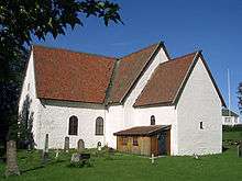
| Gildeskål | Gildeskål Church | Inndyr | 1881 |
| Old Gildeskål Church | Inndyr | 12th century | |
| Saura Church | Saura | 1884 | |
| Mevik Chapel | Mevik | 1910 | |
| Nordstranda Chapel | Lekanger | 1963 | |
| Sørfjorden Chapel | Sørfinnset | 1957 |
Geography

Gildeskål is a coastal municipality that encompasses part of the mainland as well as many islands. Major islands include Fleinvær, Fugløya, Nordarnøya, Sandhornøya, and Sørarnøya. The southern part of the municipality includes part of the Saltfjellet mountains and the northern part of the municipality borders the Saltfjorden and the Vestfjorden.
There are many lakes in the municipality including: Fellvatnet, Langvatnet, Litle Sokumvatnet, and Sokumvatnet.
Government
All municipalities in Norway, including Gildeskål, are responsible for primary education (through 10th grade), outpatient health services, senior citizen services, unemployment and other social services, zoning, economic development, and municipal roads. The municipality is governed by a municipal council of elected representatives, which in turn elect a mayor.
Municipal council
The municipal council (Kommunestyre) of Gildeskål is made up of 17 representatives that are elected to four year terms. Currently, the party breakdown is as follows:[6]
| Party Name | Name in Norwegian | Number of representatives | |
|---|---|---|---|
| Labour Party | Arbeiderpartiet | 7 | |
| Progress Party | Fremskrittspartiet | 2 | |
| Conservative Party | Høyre | 3 | |
| Centre Party | Senterpartiet | 3 | |
| Socialist Left Party | Sosialistisk Venstreparti | 1 | |
| Local Lists | Lokale lister | 1 | |
| Total number of members: | 17 | ||
Buildings and structures
Sandhornøy Bridge connects the island of Sandhornøya to the mainland.
There is a VLF-transmitter in Gildeskål that is used for sending messages to submerged submarines (call sign: JXN, frequency: 16.4 kHz). It uses as antenna multiple wires spun between two mountains (photo). The transmitter building is located at 66°58′58″N 13°52′23″E / 66.98278°N 13.87306°E.
References
- ↑ "Navn på steder og personer: Innbyggjarnamn" (in Norwegian). Språkrådet. Retrieved 2015-12-01.
- ↑ Statistisk sentralbyrå (2017). "Table: 06913: Population 1 January and population changes during the calendar year (M)" (in Norwegian). Retrieved 2017-09-09.
- ↑ Jukvam, Dag (1999). "Historisk oversikt over endringer i kommune- og fylkesinndelingen" (PDF) (in Norwegian). Statistisk sentralbyrå.
- ↑ Rygh, Oluf (1905). Norske gaardnavne: Nordlands amt (in Norwegian) (16 ed.). Kristiania, Norge: W. C. Fabritius & sønners bogtrikkeri. p. 182.
- 1 2 "Kommunevåpenet" (in Norwegian). Gildeskål kommune. Archived from the original on 2011-07-24. Retrieved 2008-11-20.
- ↑ "Table: 04813: Members of the local councils, by party/electoral list at the Municipal Council election (M)" (in Norwegian). Statistics Norway. 2015.
External links
- Municipal fact sheet from Statistics Norway (in Norwegian)
| Wikimedia Commons has media related to Gildeskål. |

| |||||||||||||||||
| |||||||||||||||||