Alexandria Canal (Virginia)
|
Alexandria Canal Tide Lock | |
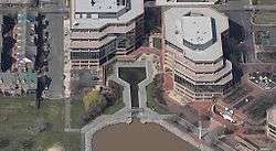 Alexandria Canal Center with reconstructed Tidal Basin and Tidal Lock | |
   | |
| Nearest city | Alexandria, Virginia |
|---|---|
| Coordinates | 38°48′49.6″N 77°2′18.2″W / 38.813778°N 77.038389°WCoordinates: 38°48′49.6″N 77°2′18.2″W / 38.813778°N 77.038389°W |
| Area | 5.7 acres (2.3 ha) |
| Built | 1833 |
| Architect | Alexandria Canal Co. |
| NRHP reference # | 80004305[1] |
| VLR # | 100-0099[2] |
| Significant dates | |
| Added to NRHP | January 15, 1980 |
| Designated VLR | November 20, 1979[2] |
The Alexandria Canal was a canal in the United States that connected the city of Alexandria to Georgetown in the District of Columbia.
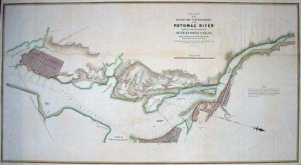
In 1830, merchants from Alexandria (which at the time was within the jurisdiction of the federal District of Columbia) proposed linking their city to Georgetown to capitalize on the new Chesapeake and Ohio Canal (C&O Canal). Congress granted a charter to the Alexandria Canal Company in 1830. Construction began in 1833 and was completed in 1843.
The Aqueduct Bridge (also begun in 1833 and completed in 1843) enabled canal boats from the C&O Canal to cross the Potomac River without descending to the river level. The boats would then continue their trips downstream on a canal on the southwest side of the Potomac until they reached Alexandria's seaport.
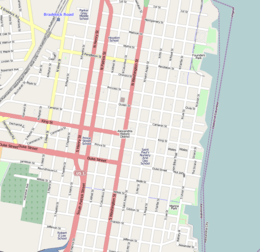
The canal ran southwards for seven miles through today's Arlington County and City of Alexandria, Virginia, dropping 38 feet through a series of four locks between Washington Street and the Potomac River in the northern portion of Alexandria. The Canal ended at a Tidal Basin (Pool No. 1) and a Tidal Lock (Lift Lock No. 1) located at the north end of Old Town Alexandria.
The canal was abandoned in 1886. Ten years after the canal closed, an electric trolley line was constructed in 1896 in Arlington on the bed of the towpath that traveled along the canal's west side (see: Washington-Mount Vernon line of the Washington, Alexandria, and Mount Vernon Electric Railway). Arlington's S. Eads Street now approximates the canal's route in this area.[3]
Also in 1896, the Washington Southern Railway opened a line that traveled between the south end of the Long Bridge and the south end of the Aqueduct Bridge.[4] The line, which passed the present site of The Pentagon, traveled along the route of the former canal in the area that lies between Arlington National Cemetery and the Potomac River.[5] The line became in 1904 the Rosslyn Connecting Railroad, which the Pennsylvania Railroad owned through a subsidiary, the Philadelphia, Baltimore and Washington Railroad (PB&W).[6]
The Rosslyn Connecting Railroad abandoned nearly all of its line in 1962 and closed in 1969.[7] The Washington Metropolitan Area Transit Authority then constructed an open section of Metrorail's Blue Line along part of the railroad's former route.[8] Also partially following the canal's earlier route, that section of the Blue Line opened on July 1, 1997.[9]
After the Key Bridge was completed in 1923, the old superstructure of the Aqueduct Bridge was removed. During the 1980s, Alexandria City archaeologists and the developer of the neighboring Trans-Potomac Canal Center excavated the Tidal Basin and Lock and covered the original remnants with a reconstruction.[10] Aside from these two features, the abutments of the Aqueduct Bridge in Georgetown and Rosslyn, and a pier of the bridge in the Potomac River upstream of the Key Bridge, all of the canal's remnants have either been removed or remain underground.
References
- ↑ "Alexandria Canal Tide Lock". National Register of Historic Places Digital Archive on NPGallery. National Park Service. Retrieved June 27, 2017.
- 1 2 "Alexandria Canal and Tidelock" (PDF). Virginia Landmarks Register. Virginia Department of Historic Resources. p. 3. Archived from the original (PDF) on June 27, 2017. Retrieved June 27, 2017.
- ↑ (1) ""Transportation" marker". HMdb.org: The Historical Marker Database. Archived from the original on June 28, 2017. Retrieved June 28, 2017.
(2) Coordinates of S. Eads Street at 18th Street S.:38°51′27″N 77°03′11″W / 38.8574133°N 77.0530951°W - ↑ (1) Wilson, William Bender (1899). History of the Pennsylvania Railroad Company: with Plan of Organization, Portraits of Officials and Biographical Sketches. 1. Philadelphia: Henry T. Coates & Co. p. 332. OCLC 671596804. Retrieved June 27, 2017 – via Google Books.
(2) "Corporate Genealogy: Washington Southern: Development of Fixed Physical Property". Valuation Reports. Washington, D.C.: Interstate Commerce Commission. 31: 297–299, 310–313. July 1930 – via rnetzlof.pennsyrr.com. - ↑ (1) Roberts, John (Denton, Texas) (February 4, 2013). "Comments". Abandoned Rails.com: Alexandria to Bluemont. Archived from the original on July 1, 2017. Retrieved July 1, 2017.
The Pennsylvania Railroad had a very short line over on the Virginia side of the river. It ran from the Virginia end of the 14th Street Bridge to a terminal in Roslyn. I am not sure if the Pennsylvania Branch connected to the W&OD Roslyn Branch, but the ends of the two branches were very close. The Pennsylvania Branch served the old Pickle Factory that later served as the power house for the Pentagon. Then it ran in front of the Potomac-facing side of the Pentagon and then followed the route of the old Georgetown and Alexandria Canal to Roslyn. At the Pentagon, the rails ran under the concrete east entrance. That is, it did not run under the Pentagon Building itself. The branch line was not electrified, even though the Pennsylvania electric lines ran across the 14th Street Bridge to Potomac Yard.
(2) CSXvet (July 26, 2003). "Re: W&OD Railroad - Adjacent to Pentagon?". Nostalgia & History > W&OD Railroad. Trainorders.com. Archived from the original on July 1, 2017. Retrieved July 1, 2017 – via Digicert.com.The railroad that ran past the Pentagon was the onetime Pennsylvania RR Rosslyn branch. This branch left the mainline at RO (for Rosslyn) tower at the south end of the bridge over the Potomac and basically followed the Potomac northwest to Rosslyn. Part of it was built on the bed of the old canal that connected Alexandria with the C&O Canal in Georgetown. The line was always strictly freight and served some building supply companies in Rosslyn. Although the W&OD also terminated in Rosslyn, there was no connection between the two. The PRR's terminal was on the east side of town, and the W&OD ended just west of the Rosslyn traffic circle. I can't tell you when the Rosslyn end was abandoned, but I think the line remained intact as far as the Pentagon for some years longer.
- ↑ (1) History: Rosslyn Connecting Railroad Co. Third Annual Report of the State Corporation Commission of Virginia for the Year Ending December 31, 1905. 2. Richmond, Virginia: Davis Bottom, Superintendent Public Printing. 1906. p. 541. OCLC 5329199. Retrieved June 27, 2017 – via Google Books.
(2) Pennsylvania Railroad (1958). Rosslyn Connecting Railroad Company. Record of Transportation Lines Owned and Operated by and Associated in Interest with the Pennsylvania Railroad. Philadelphia. p. 74. OCLC 35068648. Retrieved June 27, 2017 – via Google Books.
(3) "Rosslyn Connecting Railroad" (PDF). Cheyenne, Wyoming: LaBelle Woodworking Company. Archived from the original (PDF) on June 28, 2017. Retrieved June 27, 2016.
(4) "Rails and Transit in Washington DC" (blog). Penney Vanderbilt and KC Jones: All About Railroads – via WordPress.As well as owning the bridge from Washington to Virginia used by all passengers from the south, the Pennsylvania Railroad also owned the Rosslyn Connecting Railroad. This line ran from Potomac Yard to Rosslyn and used to supply the Pentagon (which it almost touched) with coal.
(5) "Certificate: Rosslyn Connecting Railroad Company - Virginia 1944". Scripophily.com. Archived from the original on June 28, 2017. Retrieved June 27, 2017.Continuing south in Virginia was the Alexandria and Washington Railroad, opened in 1857. The Baltimore and Potomac acquired this line after reaching it, operating it until 1901, when the Washington Southern Railway (the successor of the Alexandria and Washington) was taken over by the Richmond, Fredericksburg and Potomac Railroad, an independent bridge line owned equally by the PRR and five other railroads. Soon after, in 1904, the line from the Long Bridge to Rosslyn, built by the Washington Southern, was split off into the Rosslyn Connecting Railroad, owned by the PRR.
- ↑ (1) "Rosslyn Connecting". Traffic World. Washington, D.C.: Traffic Service Corporation. 110: 95. 1962. ISSN 0041-073X. OCLC 1767684. Retrieved July 3, 2017 – via Google Books.
The Commission .... has authorized the carrier to abandon a portion of line extending from valuation point 26 plus 49 near the Pentagon to ....
(2) "Rosslyn Connecting Railroad". Interstate Commerce Commission Reports: Reports and Decisions of the Interstate Commerce Commission of the United States. United States Government Printing Office. 327: 959. 1969. ISSN 0083-1530. OCLC 1768456. Retrieved July 3, 2017 – via Google Books.Rosslyn Connecting Railroad Company. — A class II railroad operating 2.69 miles of road from south of Potomac Bridge to Rosslyn, Va. This road abandoned 2.3 miles of road in 1962. It is wholly owned by the Philadelphia, Baltimore and Washington Railroad Company, a subsidiary of P.R.R.
(3) "Rosslyn Connecting Railroad Memorabilia Value Guide", Railroad Collectables, Dale@RailroadCollectibles.com, 2014, archived from the original on July 1, 2017, retrieved July 2, 2017,The Rosslyn Connecting Railroad started operations in 1904 and stopped service in 1969 for a total period of operations of 65 years.
- ↑ (1) Frank IBC (July 26, 2014). "Comments". The Metro plan has changed a lot since 1968. Greater Greater Washington. Archived from the original on June 28, 2017. Retrieved June 28, 2017.
There used to be a rail line from Rosslyn to the Long Bridge, but that was replaced by the Blue Line
(2) Coordinates of Metrorail's Blue Line at Arlington Cemetery Metro Station:38°53′03″N 77°03′46″W / 38.884224°N 77.062888°W - ↑ (1) Feaver, Douglas B. (July 1, 1977). "Today, Metro could be U.S. model". The Washington Post. p. A1. Archived from the original on July 1, 2017. Retrieved July 1, 2017.
With the opening today of its 12-mile-long Blue Line from National Airport to RFK Stadium, Washington's Metro subway grows from a downtown demonstration line into the spine of a regional transportation system that could rival the Capital Beltway in its effect on Washington.
(2) "Metro History" (PDF). Washington Metropolitan Area Transit Authority. Archived from the original (PDF) on July 1, 2017. Retrieved July 1, 2017.1977 ... July 1: Blue Line opens from National Airport to Stadium-Armory — 18 stations and 12 miles of line.
- ↑ (1) "The Alexandria Canal: Gone but Not Forgotten". Jaybird's Jottings. December 3, 2015. Archived from the original on June 27, 2017. Retrieved June 27, 2017.
(2) "Alexandria Canal". Alexandria Archaeology Museum. Government of the City of Alexandria, Virginia. Archived from the original on March 13, 2007. Retrieved July 16, 2014.
(3) * "Alexandria Canal and Tide Lock: Canal Center Plaza". Alexandria Sites on the National Register of Historic Places. Alexandria, Virginia: Government of the City of Alexandria. May 24, 2017. Archived from the original on June 27, 2017. Retrieved June 27, 2017.
- Hahn, Thomas Swiftwater; Kemp, Emory L. (1992). The Alexandria Canal: Its History & Preservation. Morgantown, West Virginia: West Virginia University Press. ISBN 978-1-885907-01-1. LCCN 94622545. OCLC 904170672 – via Google Books.
- Barr, Keith L. (1989). The Alexandria Canal: Tidewater Terminus of the Chesapeake and Ohio Canal System. Alexandria Archaeology Publications.
- Department of Planning and Community Development & Alexandria Archaeology, Office of Historic Alexandria. "Alexandria Canal" (PDF). Government of the City of Alexandria, Virginia. Archived from the original (brochure) on June 26, 2017. Retrieved June 26, 2017.
- Bertsch, Amy; Mallamo, Lance (September 6, 2007). "The Alexandria Canal Tide Lock" (PDF). Marking Time. Alexandria Times. Archived from the original (PDF) on June 27, 2017. Retrieved June 26, 2017 – via Office of Historic Alexandria, Government of the City of Alexandria, Virginia.
External links
- Maps and aerial photos
- Aqueduct Bridge abutment, Georgetown: Hybrid satellite image/map from WikiMapia
- Aqueduct Bridge pier, Potomac River: Hybrid satellite image/street map from WikiMapia
- Aqueduct Bridge abutment, Rosslyn: Hybrid satellite image/street map from WikiMapia
- Metrorail Blue Line on former Alexandria Canal route, Arlington: Hybrid satellite image/street map from WikiMapia
- S. Eads Street on former Alexandria Canal route, Arlington: Hybrid satellite image/street map from WikiMapia
- Restored Tidal Basin and Lock of Alexandria Canal, Alexandria: Hybrid satellite image/street map from WikiMapia

