Yoho National Park
Yoho National Park (/ˈjoʊhoʊ/)[1] is a national park of Canada in British Columbia. It is located in the Rocky Mountains along the western slope of the Continental Divide of the Americas in southeastern British Columbia. The word Yoho is a Cree expression of amazement or awe, and it is an apt description for the spectacular landscape of massive ice fields and mountain peaks that rank among the highest in the Canadian Rockies.[2] Yoho NP is bordered by Kootenay National Park on the southern side and Banff National Park on the eastern side in Alberta.
| Yoho National Park | |
|---|---|
IUCN category II (national park) | |
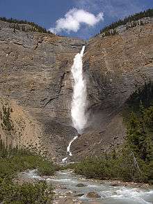 Takakkaw Falls | |
_location_map.svg.png) Location of Yoho National Park | |
| Location | British Columbia, Canada |
| Nearest city | Golden |
| Coordinates | 51°23′43″N 116°29′12″W |
| Area | 1,313 km2 (507 sq mi) |
| Established | October 10, 1886 |
| Governing body | Parks Canada |
| World Heritage site | 304 |
Yoho covers 1,313 square kilometres (507 sq mi), and it is the smallest of the four contiguous national parks. Yoho, together with Jasper, Kootenay and Banff National Parks, along with three British Columbia provincial parks—Hamber Provincial Park, Mount Assiniboine Provincial Park, and Mount Robson Provincial Park—form the Canadian Rocky Mountain Parks World Heritage Site. The park's administrative and visitor centre are located in Field, British Columbia, beside the Trans-Canada Highway.
History
The park was created following a trip by Prime Minister John A. Macdonald and his wife Agnes through the Rockies on the newly completed Transcontinental Railway. Inspired on his return to Ottawa, Yoho National Park was created on October 10, 1886. Glacier National Park was created on the same day, becoming the second and third national parks in the country, after Banff.
The contiguous national parks of Banff, Jasper, Kootenay and Yoho, as well as the Mount Robson, Mount Assiniboine and Hamber provincial parks were declared a UNESCO World Heritage Site in 1984.[3]
Fauna
Common species of animals that roam in this park are the timber wolf, coyote, badger, moose, elk, mule deer, mountain goat, golden-mantled ground squirrel, rufous hummingbird, hoary marmot, wolverine, cougar, pika, lynx, grizzly bear, and black bear.
Climate
The weather in the park is localized and changeable.[4] Being located on the western side of the continental divide, it receives more precipitation than areas east of the divide.[4] Precipitation in the park increases with elevation.[4] In winter, average temperatures are between 5 to −15 °C (41.0 to 5.0 °F) from the months November to April although temperatures can range between 10 to −35 °C (50.0 to −31.0 °F).[4] The coldest weather usually occurs in the months December to February.[4] In summer, mean temperatures average 12.5 °C (54.5 °F) with an average high of 20 °C (68.0 °F) and an average low of 5 °C (41.0 °F).[4] Snowfall and freezing temperatures can occur during the summertime at altitudes above 1,500 m (4,900 ft).[4]
Geology
The Kicking Horse River, a Canadian Heritage river, originates in the Wapta and Waputik icefields in the park. This river has created a natural bridge through solid rock. This formation is located 3 km west of Field, accessible from the road to Emerald Lake.
The Canadian Rockies consist of sedimentary rock, with numerous fossil deposits. In particular, the Burgess Shale, located in Yoho National Park, has among the world's richest deposits of rare fossils. The Burgess Shale was discovered in 1909 by Charles Doolittle Walcott. In the southeastern corner of the park is an igneous intrusion known as the Ice River Complex containing deposits of sodalite, an ornamental stone.
Mountains
- Mount Goodsir 3,567 m (11,703 ft)
- Mount Vaux 3,310 m (10,860 ft)
- Mount Balfour 3,272 m (10,735 ft)[5]
- Chancellor Peak 3,266 m (10,715 ft)
- Mount Stephen 3,199 m (10,496 ft) is the tallest of the four mountains that surround the town of Field, British Columbia. A portion of the Burgess Shale fossils were discovered on Mount Stephen.
- Cathedral Mountain 3,189 m (10,463 ft)
- The President 3,138 m (10,296 ft)
- Odaray Mountain 3,137 m (10,292 ft)
- The Vice President 3,077 m (10,095 ft)
- Wapta Mountain 2,778 m (9,114 ft)
- Mount Field 2,643 m (8,671 ft)
- Mount Burgess 2,599 m (8,527 ft) is a frequently climbed mountain. For 17 years it was featured on the Canadian ten-dollar bill.
- Paget Peak 2,560 metres (8,400 ft)
Waterfalls
- Takakkaw Falls have a total height of 373 metres (1,224 ft),[6] making it the 2nd tallest waterfall in Canada.[7][8] The main drop of the waterfall has a height of 254 metres (833 ft).[6]
- Wapta Falls is the largest waterfall of the Kicking Horse River, at about 30 metres (98 ft) high and 150 metres (490 ft) wide.[9][10] Its average flow can reach 254 cubic metres per second (9,000 cu ft/s).[11][12]
See also
| Wikimedia Commons has media related to Yoho National Park. |
- List of lakes in Yoho National Park
- Emerald Lake
References
- Parks Canada (2017-07-26). Parks Can Can Canada 2017. Retrieved 2019-05-19.
- "Kicking Horse – Canadian Heritage Rivers System Canada's National River Conservation Program". chrs.ca. Retrieved 2019-06-18.
- "Canadian Rocky Mountain Parks". World Heritage list. UNESCO. Retrieved August 26, 2010.
- "Yoho National Park Weather". Parks Canada. Retrieved August 22, 2015.
- "Peakfinder - Mount Balfour".
- "Takakkaw Falls". Encyclopædia Britannica. Retrieved 25 February 2019.
- Evans, David. "Takakkaw Falls". The Canadian Encyclopedia. Retrieved 25 February 2019.
- "Waterfalls in the Canadian Rockies: Field, British Columbia". www.field.ca. Retrieved 13 August 2018.
- "Northwest Waterfall Survey". www.waterfallsnorthwest.com.
- Wapta Falls at Berkeley
- "Waterfalls of British Columbia - Wapta Falls; Yoho Natl. Park". www.waterfallswest.com.
- "Wapta Falls - Waterfalls of the Northeastern United States". www.northeastwaterfalls.com.
External links
| Wikivoyage has a travel guide for Yoho National Park. |
- Parks Canada web site
- A travel guide for Yoho National Park and the village of Field, BC
- "Yoho National Park". The Canadian Encyclopedia
- Yoho National Park ( Bivouac.com)
| National Parks |
|
|---|---|
| Marine Conservation Areas | |
| National Landmarks | |
| |
| Western | |
|---|---|
| Eastern | |
| Northern | |
| Tentative List | |
| Former |
|
| |
| |||||||||||||||||||||||||||||||||
| |||||||||||||||||||||||||||||||||
| |||||||||||||||||||||||||||||||||
| |||||||||||||||||||||||||||||||||
| |||||||||||||||||||||||||||||||||
| Authority control |
|
|---|