Mount Balfour
Mount Balfour is a mountain located on the Continental Divide, part of the border between British Columbia and Alberta, in the Waputik Range in the Park Ranges of the Canadian Rockies.[1][2]It is the 71st highest peak in Alberta[7] and the 113th highest in British Columbia[8]; it is also the 52nd most prominent in Alberta.
| Mount Balfour | |
|---|---|
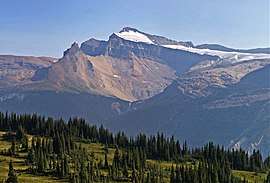
 Mount Balfour from Iceline Trail | |
| Highest point | |
| Elevation | 3,284 m (10,774 ft) [1] |
| Prominence | 934 m (3,064 ft) [2] |
| Parent peak | Howse Peak (3295 m)[2] |
| Listing | Mountains of Alberta Mountains of British Columbia |
| Coordinates | 51°33′55″N 116°27′58″W [3][4] |
| Geography | |
 Mount Balfour Location in Alberta  Mount Balfour Mount Balfour (British Columbia) | |
| Country | Canada |
| Provinces | Alberta and British Columbia |
| Parent range | Waputik Range |
| Topo map | NTS 82N/09[4] |
| Climbing | |
| First ascent | 1898 C.L. Noyes, C.S. Thompson, G.M. Weed; Appalachian Mountain Club[5][6] |

The mountain was named by James Hector in 1859 after Professor John Hutton Balfour, a Scottish botanist and instructor at the University of Edinburgh where Hector had studied.[3]
Climbing History
Early attempts to climb the mountain were made from Niles Pass via Sherbrooke Lake.[6] The first ascent was made on August 18, 1898 by C.L. Noyes, C.S. Thompson, G.M. Weed; members of the Appalachian Mountain Club. The party started their ascent from Hector Lake which they had reached by crossing Dolomite Pass to Bow Lake and then continuing south. C.E. Fay had also attempted the mountain in 1898 via the Sherbrooke Lake/Niles Pass approach but were eventually turned back by poor weather and inexperience.[5] Parties from the ACC completed ascents of Balfour in 1909 via Sherbrooke Lake, Niles Pass, Daly Glacier and then summitting via the SE arête.[6]
Geology
Mount Balfour is composed of sedimentary rock laid down during the Precambrian to Jurassic periods.[9] Formed in shallow seas, this sedimentary rock was pushed east and over the top of younger rock during the Laramide orogeny.[10]
Climate
Based on the Köppen climate classification, Mount Balfour is located in a subarctic climate with cold, snowy winters, and mild summers.[11] Temperatures can drop below −20 °C with wind chill factors below −30 °C.
References
- "Mount Balfour". PeakFinder.com. Retrieved 2019-08-20.
- "Mount Balfour". Bivouac.com. Retrieved 2009-02-21.
- "Mount Balfour". BC Geographical Names. Retrieved 2013-06-15.
- "Mount Balfour (BC)". Geographical Names Data Base. Natural Resources Canada. Retrieved 2019-08-26.
- "Waputik Icefield". bivouac.com. Retrieved 2019-08-26.
- Thorington, J. Monroe (1966) [1921]. "Kicking Horse Pass to Howse Pass". A Climber's Guide to the Rocky Mountains of Canada. With the collaboration of Putnam, William Lowell (6th ed.). American Alpine Club. pp. 136–137. ISBN 978-1376169003.
- "Peaks in Alberta by height". bivouac.com. Retrieved 2019-08-26.
- "List of peaks in BC". bivouac.com. Retrieved 2019-08-26.
- Belyea, Helen R. (1960). The Story of the Mountains in Banff National Park (PDF). parkscanadahistory.com (Report). Ottawa: Geological Survey of Canada. Archived (PDF) from the original on 2015-10-02. Retrieved 2019-09-13.
- Gadd, Ben (2008). "Geology of the Rocky Mountains and Columbias". Missing or empty
|url=(help) - Peel, M. C.; Finlayson, B. L. & McMahon, T. A. (2007). "Updated world map of the Köppen−Geiger climate classification". Hydrol. Earth Syst. Sci. 11: 1633–1644. ISSN 1027-5606.