Seton Portage Historic Provincial Park
Seton Portage Historic Provincial Park is a provincial park in British Columbia, Canada.
| Seton Portage Historic Provincial Park | |
|---|---|
_location_map.svg.png) Seton Portage Historic Provincial Park in British Columbia | |
| Location | Canada |
| Nearest city | Lillooet |
| Coordinates | 50°42′23″N 122°17′36″W |
| Area | 0.7 ha (1.7 acres) |
| Established | March 29, 1972 |
| Governing body | BC Parks |
It was established to commemorate the location of the first railway in the province of British Columbia. The 3 kilometres (1.9 mi) long railway was built in 1861 for transport of miners' goods on the route to the Fraser goldfields in which the Portage was an important link (then known as Short Portage). The railway was horse-drawn in the uphill direction - a difference of only 15m between the two lakes, and used gravity for its descent. Known as Dozier's Way after its proprietor, Carl Dozier, the roadbed of the route remains today as the route of most of Portage Road from Nkiat to the "downtown" of Seton Portage to Slosh, though part of its route is preserved by the historic park(Nkiat and Slosh are two First Nations villages which are where the one-time gold rush ports of Wapping and Flushing were located). Though the route was used for heavy transit again, the early railway operated only a few years, though some transport and passenger traveled through the route, despite its becoming a backwater relative to other areas of the province and the Douglas Road became forgotten. Seton Portage received its current name in 1858, the centennial of the gold rush and the colony's creation, until which time it was known as the Short Portage - but also, with Shalalth, as "Seton". The Lillooet Cattle Trail was built through the same route as the Douglas Road but, despite an ingenious and fragile catwalk along the cliffs of eastern Seton Lake, was not usable in the long run and was abandoned and derelict by the time the Pacific Great Eastern connected the Seton communities to Lillooet in 1915.
Facilities
A gravel-bed campground is more suitable for vehicular camping than tenting, and is located adjacent to the railway line through the Portage. The site is forested with pine and the light underbrush typical of the area's climate. Stores, a motel and restaurant are located within walking distance, as is the foot of Anderson Lake and the beaches there. At the park, in addition to campgrounds, picnic tables and sanitary facilities, an old railway caboose hosts the present day information center.
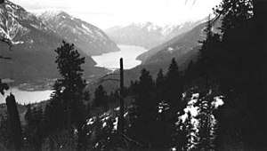
The park can be found west of Lillooet, along the Seton River, between Anderson Lake and Seton Lake, immediately west of the settlement of Seton Portage. Passenger service to this location is no longer available, other than a local run from Lillooet, on the Canadian National Railway line. Access is otherwise via the arduous Mission Mountain Road or the even more difficult Anderson Lake Highline Road, which are Seton Portage's and Shalalth's only road access to the outside world.
It was established on March 29, 1972 on land donated by the British Columbia Railway to the province.
References
- BC Parks. "Seton Portage Historic Provincial Park".