Fort Langley National Historic Site
Fort Langley National Historic Site, commonly shortened to Fort Langley, is a former trading post of the Hudson's Bay Company, now located in the community of Fort Langley opposite McMillan Island.[1][2] Commonly referred to as "the birthplace of British Columbia", it is designated a National Historic Site and is administered by Parks Canada.
| Fort Langley National Historic Site | |
|---|---|
| Fort Langley | |
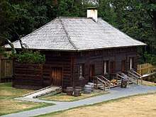
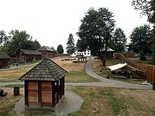 View from inside Fort Langley National Historic Site | |
| Location | 23433 Mavis Ave, Fort Langley, British Columbia, Canada V1M 3R5 |
| Founder | James McMillan |
| Built | 1827 (original fort) 1839 (second fort) |
| Original use | Trading post |
| Current use | Living museum |
| Governing body | Parks Canada |
| Website | Fort Langley National Historic Site |
| Designated | 1955 |
 Location of Fort Langley National Historic Site in British Columbia | |
History
Pre-Contact
Before Fort Langley was established, the area of the Fraser Valley has been home to the Sto:lo people for millennia. The Sto:lo people used the Fraser River as a major source of resources and enabled them to travel and interact with neighbouring Indigenous communities.[3] The area of the Fraser Valley is described as being “one of the most economically productive regions of the Pacific Northwest” pre-contact.[4] Within this area, the Sto:lo people developed highly complex social hierarchies, artistic traditions, and architecture.[4]
Background
After John Jacob Astor's Pacific Fur Company sold its assets in the Oregon Country to the North West Company following the War of 1812, Astor's Fort Astoria was renamed Fort George and became the main depot for Pacific interior trade. Pelts collected in the northern New Caledonia district travelled south along the Fraser River to Fort Alexandria, then overland via a route known as the Brigade Trail to Fort Okanagan then along the Columbia River to Fort George on the coast.
The Oregon Country/Columbia District was shared between the British and Americans as a result of the Treaty of 1818, but the treaty was to expire in 1828 and since Fort George stood on the south side of the Columbia River, it would likely be awarded to the United States in any boundary agreement. According to the Royal Proclamation of 1763, the land belonged to the Sto:lo nation, and without signing nation to nation treaties between the British government and the Sto:lo, settler or company occupation of the land was illegal.[5] After the North West Company merged with the Hudson's Bay Company in 1821, the HBC administrator George Simpson suggested the creation of Fort Vancouver on the northern bank of the Columbia, but that it serve as secondary post to a larger trade hub further north near the mouth of the Fraser River.[6] Simpson felt such a location help secure the coast from ocean-based American competition, and believed the Fraser to be more navigable than the Columbia River. He sent Chief Trader James McMillan to explore the region, and McMillan proposed an area near the Salmon River suitable to agriculture, and where fish were plentiful.[6]
First Fort Langley
James McMillan returned to the Fraser River with 24 men, including four Iroquois, two Native Hawaiian Kanaka, and one Métis worker,[7] in 1827 to begin the construction of Fort Langley (named for Thomas Langley, a prominent HBC director[8]) 50 kilometres (31 mi) from the mouth of the Fraser River. The construction of this fort represented the first permanent contact of European settlers with Indigenous peoples on the Fraser River.[9] This site was not the same as today's fort, but 4 km to the northwest at what was known by local Indigenous people as snaqʷaməx, and later called Old Fort Langley and finally renamed Derby in 1858 (now only farmland). But when they arrived at the end of July, five of the men were incapacitated with gonorrhea, another with "venereal disease", and all the horses were either dead, crippled, or exhausted.[6] Despite these setbacks and the heavy brambles at the site, the remaining 19 men began to clear the land in preparation for the fort. The men at the fort were entirely at the mercy of the Sto:lo people, as they lacked the skills and knowledge to survive off of the land. To ensure lasting economic relationships with the Sto:lo, the men at the fort were encouraged to take Sto:lo women as their wives. The economic and social patterns adopted by the settlers post-contact illustrates their dependency on the Sto:lo (the original inhabitants of the land)[5]. Potatoes were planted in a garden during the establishment of Fort Langley.[10] The first bastion was built by mid-August in order to defend against another attack by the Sto:lo, a second at the end of the month, and the palisade walls were completed in early September.[6] Some of the Hudson's Bay men were nervous about the Indigenous people of the Fraser, and the bastions were completed first "to command respect in the eyes of the Indians, who begin, shrewdly, to conjecture for what purpose the Ports and loopholes are intended."[11] After the stockade was complete only Indigenous people with furs were allowed past the gate.[10] A number of buildings were built through autumn, and Fort Langley was officially completed on November 26. Native laborers resided in a camp a short distance from the station.[10]
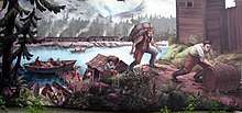
During the first few years, trade in furs with the Stó:lō, the Indigenous people (Fraser River), was surprisingly poor from the HBC point of view. Firstly, traders from Boston controlled most of the Maritime Fur Trade, travelling along the coast by boat. Such strong competition kept the price of pelts very high, much higher than Hudson's Bay was paying elsewhere. McMillan was advised by his superiors to intentionally undersell Americans in order to force them out of the region and assure a monopoly for the HBC.[6] This came in the form of a trade tariff on that Indigenous people that they identified as a trading disadvantage where five beaver skins were required to receive one two-and-a-half point HBC blanket.[10] Second, Indigenous people living along the river were not particularly interested in hunting or trapping, since they lived primarily on salmon. The Stó:lō initiated trade of salmon with the HBC, which would later become an important export of the Fort.[12][13] As they had little contact with Europeans, they were quite self-sufficient and not in serious need of European goods.[6] In the first year, guns were in high demand by the Stó:lō to fend off attacks from the Laich-kwil-tach, but when this threat died down, firearms became mainly symbolic yet infrequent items of trade.[11] 1829 and 1831 were the most successful years for the fort's fur trading operations, each year netting 2,500 skins.[10] Salmon pickling was begun by staff of the fort, creating nearly 300 barrels in 1831.[10]
Also a disappointment to the HBC was Simpson's discovery that the Fraser was not as navigable as he had imagined. Along with Archibald McDonald (who would later replace McMillan at Fort Langley), Simpson travelled from York Factory to Fort St. James, the centre of trade for New Caledonia, before assembling a group of men (including James Murray Yale, who would later replace McMillan) to descend the Fraser towards Fort Langley. Their party found that travel down the Fraser was relatively easy until it forked with the Thompson River, after which the powerful rapids and sheer cliffs convinced Simpson the passage would be "certain Death, in nine attempts out of Ten."[6] At least some part of the journey from the north would have to be made overland to bypass the Fraser Canyon and Hell's Gate.
Second Fort Langley
As part of its plan to rid itself of American competition, the HBC sought to corner the market in Alaska by securing a monopoly on trade with the Russian American Company in 1839. McMillan went to many lengths to ensure that the Indigenous people were kept at a distance during the construction of the second fort.[10] The location of the fort was moved four kilometres upstream in 1839 and changed its focus to farming, fish, and cranberry harvesting, rather than the fur trade.[14] Trading was now only allowed through a wicket, with sentries posted on the second story.[10] In 1840 the farm had "potatoes abundant" along with 750 bushels of wheat, 500 bushels of oats and 600 bushels of peas.[10] Catholic Missionary Modeste Demers traveled to Fort Langley and performed religious services for the staff and neighboring Indigenous, baptising over 700 children in 1841.[10] Despite baptizing many, white men would still administer beatings to Indigenous people who did not behave in a colonially respectful manner.[10]
Due to its strategic location on the northern boundary of the Oregon Territory of the U.S. and in the path of the Fraser Canyon Gold Rush, Fort Langley grew dramatically. It played a key role in the establishment of the 49th parallel as the international boundary with the U.S. and was the staging point for prospectors heading up the Fraser Canyon in search of their fortune. The gold rush represented a turning point for many of the Indigenous peoples of the Fraser Valley who experienced a loss of their trading relationship with the HBC and encroachment onto their land by settlers.[15] Non-native settlement on the Fraser river compromised Indigenous access to their traditional fishing sites and land, leading to a disruption in the regularity of their traditional practices. Moreover, legal restrictions on the trade of Indigenous catch made it difficult for the Stó:lo to trade fish to make a living.[16]
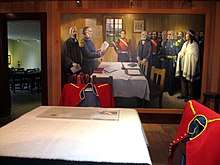
The social and political consequences of this influx of adventurers led the British Parliament to establish a crown colony on the Pacific Mainland. Old Fort Langley was the location of the proclamation of the Crown Colony of British Columbia in 1858 by James Douglas, the colony's first governor, during his journey upriver to confront American miners in the wake of the Fraser Canyon War as a pre-emptive move to forestall any drives for annexation to the US.
While some might have projected Fort Langley as the capital of the newly created colony, Colonial military commander, Colonel Moody of the Royal Engineers, Columbia Detachment, deemed it militarily indefensible and ordered the construction of New Westminster on the high north bank of the Fraser River many miles downstream due to its much more defensible position.
Recent history
The decline of the fort over the next 30 years was attributed to three factors. First, the advent of paddle wheelers on the Fraser meant that river traffic was extended to Fort Hope and Fort Yale. Second, the capital of the colony was established at New Westminster, British Columbia and later moved to Victoria. Finally, competition for goods and services undercut the monopoly the Hudson's Bay Company had formerly enjoyed. In 1886, Fort Langley ceased to be a company post.
In 1923, the Canadian government designated Fort Langley as a National Historic Site and erected a commemorative plaque near the storehouse.[17] At this time, the site consisted only of the one building and 1-acre (4,000 m2) of land. From 1931 to 1956, the Native Sons and Daughters of British Columbia operated a museum out of the storehouse. Parks Canada took control of the site in 1955, and a joint Federal-Provincial program reconstructed three buildings in time for the centennial of the founding of British Columbia in 1958. In 1978, the site became a national historic park, and has consisted of 8.5 hectares (21 acres) since 1985.
In 2019, the students of Langley Fine Arts School worked alongside the community members of the Kwantlen Nation as a part of the project This is Kwantlen, to increase Indigenous representation in Fort Langley. Photographs and biographies of Kwantlen First Nation members were displayed outside of the Fort Langley National Historic Site and throughout Fort Langley during April and May 2019.[18]
Buildings
The site has a number of historic buildings, both original and reconstructed, for guests to visit.
Bastions
The north east bastion was rebuilt in 1958, while the north west bastion has only been added more recently. There was originally a third bastion along the west palisade wall.
Big House
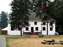
The Big House was also reconstructed for the 1958 Centennial, and is quite consistent with the original in terms of appearance and location within the Fort. It houses the living quarters of James Murray Yale and his wife; and William Henry Newton and his wife, Emmaline (Tod) Newton
Blacksmith
The blacksmith shop was first built in 1973, and then rebuilt in 1975. It features a working forge and live demonstrations of blacksmithing.
Cooperage
The cooperage was built in 1992, slightly south of the original, and features all the required tools for barrel making and other woodworking.
Depot
The Depot was reconstructed in 1997 and is mainly used as an exhibition area and administration building. The original building would have been used as a supply depot for shipments in and out of the Fort.
Exhibits building
The exhibits building, built in 2001, houses a display on the international trade done by the Hudson's Bay Company. The original building would have been a storehouse.
Servants' quarters
The servants' quarters were reconstructed in 1958 for the Centennial of the Colony of British Columbia, and portrays the living conditions of three different HBC employees. The building was used to display barrel-making until 1992 when the new cooperage was built.
Storehouse
The storehouse is the oldest building at Fort Langley, and possibly the oldest in British Columbia. It was rebuilt in the 1840s after a fire which destroyed a similar building in 1839, and was the only building which survived the demise of the Fort as an active trading post. The Mavis family, who later purchased the land, used it as a barn for a number of years, until Fort Langley was recognized as a site of historic significance in 1923.
References
- "The Children of Fort Langley". www.fortlangley.ca. Retrieved 2020-03-03.
- BC Names/GeoBC entry "Fort Langley National Historic Site of Canada"
- Lepofsky, Dana; Schaepe, David M.; Graesch, Anthony P.; Lenert, Michael; Ormerod, Patricia; Carlson, Keith Thor; Arnold, Jeanne E.; Blake, Michael; Moore, Patrick; Clague, John J. (October 2009). "Exploring Stó:Lō-Coast Salish Interaction and Identity in Ancient Houses and Settlements in the Fraser Valley, British Columbia". American Antiquity. 74 (4): 595–626. doi:10.1017/s0002731600048988. ISSN 0002-7316.
- "Sacred Sites, Sacred Places". 1994-06-16. doi:10.4324/9780203714041. Cite journal requires
|journal=(help) - Carlson, Keith (1997). You Are Asked To Witness: The Sto:lo In Canada's Pacific Coast History. Chilliwack, British Columbia, Canada: Sto:lo Heritage Trust. pp. 58–59. ISBN 0-9681577-2-6.
- Cullen, Mary K. The History of Fort Langley, 1927-96. Canadian Historical Site: Occasional Papers in Archeology & History, 1972.
- Maclachlan, Morag (November 1, 2011). "Journal Kept by George Barnston, 1827-8". Fort Langley Journals, 1827-30. UBC Press. p. 23. ISBN 978-0774841979.
- First Fort Langley National in The Langley Story Illustrated
- Nikolaus, Henry (2005). "Iwówes: A Community Profile and History" (PDF). Stó:lo Research and Resource Management Centre. Retrieved March 2, 2020.
- Sage, Walter N. Life at a Fur Trading Post in British Columbia a Century Ago. The Washington Historical Quarterly 25, No. 1 (1934), pp. 11-22
- Harris, Cole. The Resettlement of British Columbia. 1997
- Brown, K. L. (2010). Highliners and Moneymakers: Understanding Accommodation and Resistance in the Sto: lo Commercial Fishery. New Proposals: Journal of Marxism and Interdisciplinary Inquiry, 3(3), 20-31.
- Eisenberg, Avigail; Eisenberg, Associate Professor of Political Science Avigail (2009-08-27). Reasons of Identity: A Normative Guide to the Political and Legal Assessment of Identity Claims. OUP Oxford. ISBN 978-0-19-929130-4.
- Peak Production at Fort Langley, Parks Canada]
- "Kwantlen of the Coast Salish: A Halkomelem tribe". Surrey History. 2014. Retrieved March 2, 2020.
- Menzies, Charles R. (2006). Traditional Ecological Knowledge and Natural Resource Management. U of Nebraska Press. ISBN 978-0-8032-0735-6.
- Fort Langley. Canadian Register of Historic Places. Retrieved 27 November 2011.
- Fatur, Miranda (12 April 2019). "Students unveil art project that honours Kwantlen First Nation". Langley Advance Times. Retrieved 3 March 2020.
External links
- Fort Langley National Historic Site
- A 1958 home movie of a visit to the Fort
- Langley Centennial Museum
- "The Children of Fort Langley"
- A Brief History of Fort Langley
- Fort Langley (Canadian Register of Historic Places)
| Provinces | |
|---|---|
| Territories | |
| Other countries | |
| |
The Columbia Department | ||||||||
|---|---|---|---|---|---|---|---|---|
Historic HBC operations in the Pacific Northwest | ||||||||
| Columbia Department |
| |||||||
| New Caledonia District |
| |||||||