List of historic places in the Okanagan-Similkameen Regional District
The following list includes all of the Canadian Register of Historic Places listings in Okanagan-Similkameen Regional District, British Columbia.
| Name | Address | Coordinates | IDF | IDP | IDM | Image | |
|---|---|---|---|---|---|---|---|
| Similkameen Spirit Trail National Historic Site of Canada | Upper Similkameen River Valley / Vallee de la Upper Similkameen, Hedley, British Columbia, BC | 49°24′08″N 120°15′25″W | 14552 |  | |||
| Grist Mill at Keremeos | Upper Bench Road, Keremeos, BC | 49°12′50″N 119°48′29″W | 1674 | | |||
| Michael Keogan's Chimney | Alba Road, Keremeos, BC | 49°19′54″N 119°34′07″W | 20348 | | |||
| Granite Creek Town Site and Cemetery | Granite Street, SE of Coalmont, Regional District of Okanagan-Similkameen, BC | 49°30′19″N 120°40′52″W | 20165 | | |||
| Bike Barn | 300 Westminster Avenue West, Penticton, BC | 49°29′57″N 119°35′53″W | 6782 | | |||
| Fairview Cemetery | 1136 Fairview Road, Penticton, BC | 49°29′12″N 119°35′28″W | 6795 | | |||
| Gibson House | 112 Eckhardt Avenue West, Penticton, BC | 49°29′33″N 119°35′28″W | 6775 | | |||
| Gyro Bandshell | 24 Lakeshore Drive West, Penticton, BC | 49°30′07″N 119°35′42″W | 6798 | | |||
| Kettle Valley Railway Station | 216 Hastings Avenue, Penticton, BC | 49°29′04″N 119°35′38″W | 6783 | | |||
| Leir House | 220 Manor Park Avenue, Penticton, BC | 49°29′04″N 119°35′02″W | 6774 | | |||
| Munson Mountain | 650 Lower Bench Road, Penticton, BC | 49°30′56″N 119°34′26″W | 6800 |  More images | |||
| Munson/Cleland Property | 10 Upper Bench Road South, Penticton, BC | 49°30′12″N 119°33′43″W | 6796 | | |||
| Penticton High School | 158 Main Street, Penticton, BC | 49°29′32″N 119°35′13″W | 6776 | | |||
| Penticton Post Office | 301 Main Street, Penticton, BC | 49°29′56″N 119°35′33″W | 6780 | | |||
| Penticton Provincial Courthouse | 100 Main Street, Penticton, BC | 49°30′06″N 119°35′38″W | 6799 | | |||
| Riordan House | 689 Winnipeg Street, Penticton, BC | 49°29′33″N 119°35′35″W | 6779 | | |||
| S.S. Naramata | 1099 Lakeshore Drive West, Penticton, BC | 49°30′08″N 119°36′43″W | 6186 | | |||
| S.S. Sicamous | 1075 Lakeshore Drive West, Penticton, BC | 49°30′07″N 119°36′40″W | 6777 | 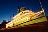 More images | |||
| Warren House | 434 Lakeshore Drive West, Penticton, BC | 49°30′05″N 119°36′00″W | 6797 | | |||
| White Lodge | 1425 McMillan Avenue, Penticton, BC | 49°30′45″N 119°33′43″W | 6778 | | |||
| Manning Park Lodge | 7500 Highway 3, Near Princeton, BC | 49°03′47″N 120°47′10″W | 18053 | | |||
| Monument 83 | , Princeton, BC | 49°00′01″N 120°38′46″W | 18048 | | |||
| Staff Residence | Highway 3, Near Princeton, BC | 49°03′49″N 120°47′06″W | 18055 | | |||
| Windy Joe Lookout | , Princeton, BC | 49°02′38″N 120°45′18″W | 18052 | | |||
| Former Superintendent’s Residence | , Summerland, BC | 49°33′56″N 119°39′07″W | 10133 | | |||
| Sod-Roofed Cabin | 4500 Landry Crescent, Summerland, BC | 49°34′58″N 119°38′31″W | 21064 | |
This article is issued from Wikipedia. The text is licensed under Creative Commons - Attribution - Sharealike. Additional terms may apply for the media files.