Canadian Rockies
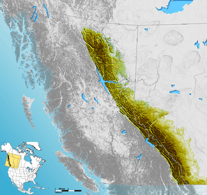
The Canadian Rockies (French: Rocheuses canadiennes) or Canadian Rocky Mountains comprise the Canadian segment of the North American Rocky Mountains. They are the eastern part of the Canadian Cordillera, which is a system of multiple ranges of mountains which runs from the Canadian Prairies to the Pacific Coast. The Canadian Rockies mountain system comprises the southeastern part of this system, lying between the Interior Plains of Alberta and northeastern British Columbia on the east to the Rocky Mountain Trench of BC on the west. The southern end borders Idaho and Montana of the United States. In geographic terms, the boundary is at the Canada–United States border, but in geological terms it might be considered to be at Marias Pass in northern Montana. The northern end is at the Liard River in northern British Columbia.
| Canadian Rockies | |
|---|---|
| Rocheuses canadiennes (French) | |
 | |
| Highest point | |
| Peak | Mount Robson |
| Elevation | 3,954 m (12,972 ft) |
| Coordinates | 53°06′38″N 119°09′21″W |
| Dimensions | |
| Length | 1,460 km (910 mi) [1] |
| Width | 180 km (110 mi) [1] |
| Area | 194,000 km2 (75,000 sq mi) [1] |
| Geography | |
 | |
| Country | Canada |
| Provinces | British Columbia and Alberta |
| Parent range | Pacific Cordillera |
| Geology | |
| Orogeny | Sevier orogeny [2] |
| Type of rock | Sedimentary rock |
The Canadian Rockies have numerous high peaks and ranges, such as Mount Robson (3,954 m, 12,972 ft) and Mount Columbia (3,747 m, 12,293 ft). The Canadian Rockies are composed of shale and limestone. Much of the range is protected by national and provincial parks, several of which collectively comprise a World Heritage Site.
Geography
The Canadian Rockies are the easternmost part of the Canadian Cordillera, the collective name for the mountains of Western Canada. They form part of the American Cordillera, an essentially continuous sequence of mountain ranges that runs all the way from Alaska to the very tip of South America. The Cordillera, in turn, is the eastern part of the Pacific Ring of Fire that runs all the way around the Pacific Ocean.
The Canadian Rockies are bounded on the east by the Canadian Prairies, on the west by the Rocky Mountain Trench, and on the north by the Liard River. Contrary to popular misconception, the Rockies do not extend north into Yukon or Alaska, or west into central British Columbia. North of the Liard River, the Mackenzie Mountains, which are a distinct mountain range, form a portion of the border between the Yukon and the Northwest Territories. The mountain ranges to the west of the Rocky Mountain Trench in southern British Columbia are called the Columbia Mountains, and are not considered to be part of the Rockies by Canadian geologists.[1]
Highest peaks
.jpg)
Mount Robson (3,954 m, 12,972 ft) is the highest peak in the Canadian Rockies, but not the highest in British Columbia, since there are some higher mountains in the Coast Mountains and Saint Elias Mountains. Mount Robson lies on the continental divide near Yellowhead Pass, one of the lowest passes in the Canadian Rockies, and is close to the Yellowhead Highway. Its base is 985 m (3,232 ft) above sea level, with a total vertical relief of 2,969 m (9,741 ft).
Mount Columbia (3,747 m, 12,293 ft) is the second-highest peak in the Canadian Rockies, and is the highest mountain in Alberta.
Snow Dome (3,456 m, 11,339 ft) is one of two hydrological apexes of North America. Water flows off Snow Dome into three different watersheds, into the Pacific Ocean, Arctic Ocean, and Atlantic Ocean via Hudson Bay.[3]
The Canadian Rockies are not the highest mountain ranges in Canada. Both the Saint Elias Mountains (highest point in Canada Mount Logan at 5,959 m, 19,551 ft) and the Coast Mountains (highest point Mount Waddington at 4,016 m, 13,176 ft) have higher summits.
Mountain ranges
The Canadian Rockies are subdivided into numerous mountain ranges, structured in two main groupings, the Continental Ranges, which has three main subdivisions, the Front Range, Park Ranges and Kootenay Ranges, and the Northern Rockies which comprise two main groupings, the Hart Ranges and the Muskwa Ranges. The division-point of the two main groupings is at Monkman Pass northwest of Mount Robson and to the southwest of Mount Ovington.
Rivers
The Canadian Rockies are noted for being the source of several major river systems, and also for the many rivers within the range itself. The Rockies form the divide between the Pacific Ocean drainage on the west and that of Hudson Bay and the Arctic Ocean on the east. Of the range's rivers, only the Peace River penetrates the range. Notable rivers originating in the Canadian Rockies include the Fraser, Columbia, North Saskatchewan, Bow and Athabasca Rivers.
Geology
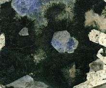
The Canadian Rockies are quite different in appearance and geology from the American Rockies to the south of them. The Canadian Rockies are composed of layered sedimentary rock such as limestone and shale, whereas the American Rockies are made mostly of metamorphic and igneous rock such as gneiss and granite.
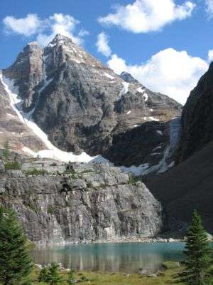
The Canadian Rockies are overall more jagged than the American Rockies, because the Canadian Rockies have been more heavily glaciated, resulting in sharply pointed mountains separated by wide, U-shaped valleys gouged by glaciers, whereas the American Rockies are overall more rounded, with river-carved V-shaped valleys between them. The Canadian Rockies are cooler and wetter, giving them moister soil, bigger rivers, and more glaciers. The tree line is much lower in the Canadian Rockies than in the American Rockies.
Parks
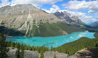
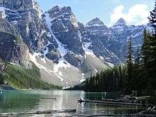
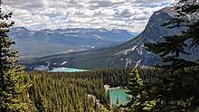
Five national parks are located within the Canadian Rockies, four of which are adjacent and make up the Canadian Rocky Mountain Parks. These four parks are Banff, Jasper, Kootenay and Yoho. The fifth national park, Waterton is not adjacent to the others. Waterton lies farther south, straddling the Canada–US border as the Canadian half of the Waterton-Glacier International Peace Park. All five of these parks, combined with three British Columbia provincial parks, were declared a single UNESCO World Heritage Site in 1984[4] for the unique mountain landscapes found there.
Numerous provincial parks are located in the Canadian Rockies, including Hamber, Mount Assiniboine and Mount Robson parks.
Throughout the Rockies, and especially in the national parks, the Alpine Club of Canada maintains a series of alpine huts for use by mountaineers and adventurers.[5]
Human history
The Rockies and the Canadian Pacific Railway
The Canadian Pacific Railway was founded to provide a link from the province of British Columbia to the eastern provinces. The main difficulty in providing such a link were the Rockies themselves: treacherous mountain passes, fast rivers and sheer drops made for a difficult railway construction process. The following articles describe in detail the political and technical feats involved:
- Canadian Pacific Survey
- Big Hill
- Field Hill
- Kicking Horse Pass
- Spiral Tunnels
See also
| Wikimedia Commons has media related to Canadian Rockies. |
| Wikivoyage has a travel guide for Rocky Mountains (Canada). |
- Ecology of the Rocky Mountains
- Geology of the Rocky Mountains
- Arctic Cordillera: an example of another major mountain system in North America east of the Canadian Rockies.
- The Rocky Mountain Rangers
Notes
- Gadd, Ben (1995). Handbook of the Canadian Rockies (2nd ed.). Corax Press. ISBN 978-0-9692631-1-1.
- "Laramide and Sevier orogenies (PLATE TECTONICS) – g17" (PDF). geowords.com. p. 423. Retrieved 2017-08-20.
- Jennings, Ken. "The Canadian Mountain Peak that Feeds Three Different Oceans". Conde Nast Traveler. Retrieved 3 March 2020.
- "Canadian Rocky Mountain Parks". World Heritage List. UNESCO. Retrieved 2010-01-01.
- "Clubhouse and Alpine Huts". Alpine Club of Canada. Archived from the original on 2009-05-06. Retrieved 2010-01-01.
References
- Adams, Ansel (2013). Ansel Adams In The Canadian Rockies. Little, Brown and Company. ISBN 978-0-316-24341-4
- Roger W. Patillo: The Canadian Rockies: Pioneers, Legends and True Tales. Trafford Publishing 2005, 9781412056274 (restricted online version (Google Books))
- Brenda Koller: The Canadian Rockies Adventure Guide. Hunter Publishing Inc. 2006, ISBN 978-1-58843-573-6 (restricted online version (Google Books))
- Canadian Rockies. (2009). In Encyclopædia Britannica. Retrieved August 22, 2009, from Encyclopædia Britannica Online[1]
| History |
| ||||
|---|---|---|---|---|---|
| Provinces and territories |
| ||||
| Government | |||||
| Politics | |||||
| Geography |
| ||||
| Economy | |||||
| Society | |||||
| Demographics |
| ||||
| Culture | |||||
| Symbols | |||||
| Article overviews | |||||
| Research | |||||
| |||||
| Authority control |
|
|---|