Mount Hungabee
Mount Hungabee, officially Hungabee Mountain, is a mountain located on the boundaries of Banff National Park and Yoho National Park on the Continental Divide at the head of Paradise Valley. The peak was named in 1894 by Samuel Allen after the Stoney Indian (also known as Nakoda) word for "chieftain" as the mountain is higher than its neighbouring peaks.[1] The mountain can be seen from the Icefields Parkway (#93) in the upper Bow Valley.
| Mount Hungabee | |
|---|---|
| Hungabee Mountain | |
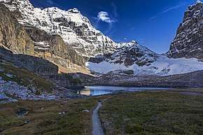
 As seen from Paradise Valley in 2007 | |
| Highest point | |
| Elevation | 3,492 m (11,457 ft) [1] |
| Prominence | 987 m (3,238 ft) [2] |
| Coordinates | 51°19′59″N 116°17′03″W [2] |
| Geography | |
 Mount Hungabee Location in Alberta | |
| Country | Canada |
| Provinces | Alberta and British Columbia |
| Parent range | Bow Range |
| Topo map | NTS 82N/08 |
| Climbing | |
| First ascent | 21 July 1903 |
| Easiest route | rock/snow climb |
Mt. Hungabee was first climbed in 1903 by H.C. Parker who was guided by Hans Kaufmann and Christian Kaufmann.[1]
Routes
The normal climbing route is via the west ridge (III 5.4) which features route finding challenges. Early summer is not recommended due to avalanche hazard from snow on the NW face.[1]
Geology
Mount Hungabee is composed of sedimentary rock laid down during the Precambrian to Jurassic periods.[3] Formed in shallow seas, this sedimentary rock was pushed east and over the top of younger rock during the Laramide orogeny.[4]
Climate
Based on the Köppen climate classification, Mount Hungabee is located in a subarctic climate with cold, snowy winters, and mild summers.[5] Temperatures can drop below −20 C with wind chill factors below −30 C.
See also
- List of peaks on the British Columbia-Alberta border
Further reading
- Chic Scott, Pushing the Limits: The Story of Canadian Mountaineering, P 175
References
- "Mount Hungabee". PeakFinder.com. Retrieved 2004-05-04.
- "Hungabee Mountain". Bivouac.com. Retrieved 2008-10-05.
- Belyea, Helen R. (1960). The Story of the Mountains in Banff National Park (PDF). parkscanadahistory.com (Report). Ottawa: Geological Survey of Canada. Archived (PDF) from the original on 2015-10-02. Retrieved 2019-09-13.
- Gadd, Ben (2008). "Geology of the Rocky Mountains and Columbias". Missing or empty
|url=(help) - Peel, M. C.; Finlayson, B. L. & McMahon, T. A. (2007). "Updated world map of the Köppen−Geiger climate classification". Hydrol. Earth Syst. Sci. 11: 1633–1644. ISSN 1027-5606.