Lake Louise, Alberta
Lake Louise is a hamlet in Alberta, Canada, within Improvement District No. 9 Banff (Banff National Park).[3]
Lake Louise | |
|---|---|
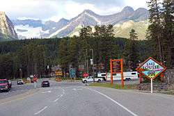 Entering Lake Louise | |
 Lake Louise Location of Lake Louise in Alberta | |
| Coordinates: 51.4253°N 116.1806°W | |
| Country | Canada |
| Province | Alberta |
| Region | Alberta's Rockies |
| Census division | No. 15 |
| Improvement district | Improvement District No. 9 |
| Government | |
| • Type | Unincorporated |
| • Governing body | Improvement District No. 9 Council |
| • MP | Blake Richards, Wild Rose |
| Elevation | 1,600 m (5,200 ft) |
| Population (2011)[2] | |
| • Total | 691 |
| Time zone | UTC−7 (MST) |
| • Summer (DST) | UTC−6 (MDT) |
| Postal code span | T0L 1E0 |
| Area code(s) | 403, 587 |
| Highways | |
| Website | Lake Louise |
History

The hamlet is named for the nearby Lake Louise, which in turn was named after the Princess Louise Caroline Alberta (1848–1939), the fourth daughter of Queen Victoria, and the wife of John Campbell, the 9th Duke of Argyll, who was the Governor General of Canada from 1878 to 1883.
The hamlet was originally called Laggan, and was a station along the Canadian Pacific Railway route. It was built in 1890.[4] The rail station building was preserved and moved into Heritage Park in Calgary.
Infrastructure
The hamlet is separated into two communities. The main community, referred to as The Village is at a lower elevation adjacent to the Trans-Canada Highway (Highway 1). It has a small shopping centre, Samson Mall, which includes a park visitor centre, grocery store, bakery, deli, grill, bar and sporting goods store. The ski area, Lake Louise Mountain Resort, is located across Highway 1. The second community is at a higher elevation and is centered on the Chateau Lake Louise, adjacent to Lake Louise.
The community is also located on Alberta Highway 1A, and just south of the Icefields Parkway.
Demographics
In 2011, Lake Louise had a population of 691 year-round residents.[2]
Geography
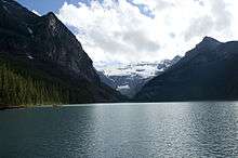
The hamlet is located in census division No. 15 and in the federal riding of Banff—Airdrie. It is administered by the Improvement District No. 9[5] and is located beside the Trans-Canada Highway, 180 km (110 mi) west of Calgary. The background of Lake Louise is filled with views of several snow-capped mountains including Mount Temple (3,543 m (11,624 ft)), Mount Whyte (2,983 m (9,787 ft)) and Mount Niblock (2,976 m (9,764 ft)).
Climate
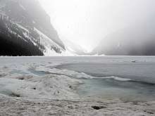
Lake Louise experiences a subarctic climate (Köppen climate classification Dfc). Annual snowfall averages 3.3m and winter temperatures below −50 °C have been recorded. Summers consist of frosty mornings and crisp, cool days. Snow can occur in any month of the year. Since lower elevations on said latitude have humid continental climates instead, it may also be described as a subalpine climate. Because of its high diurnal temperature variation and high altitude, the frost-free period averages only 14 days.[6]
| Climate data for Lake Louise (1981–2010) | |||||||||||||
|---|---|---|---|---|---|---|---|---|---|---|---|---|---|
| Month | Jan | Feb | Mar | Apr | May | Jun | Jul | Aug | Sep | Oct | Nov | Dec | Year |
| Record high °C (°F) | 7.8 (46.0) |
13.9 (57.0) |
17.0 (62.6) |
26.5 (79.7) |
31.7 (89.1) |
31.1 (88.0) |
34.4 (93.9) |
32.2 (90.0) |
29.0 (84.2) |
26.1 (79.0) |
18.3 (64.9) |
12.2 (54.0) |
34.4 (93.9) |
| Average high °C (°F) | −5.4 (22.3) |
−1.7 (28.9) |
2.9 (37.2) |
7.5 (45.5) |
12.7 (54.9) |
16.7 (62.1) |
20.4 (68.7) |
20.1 (68.2) |
14.7 (58.5) |
7.3 (45.1) |
−1.7 (28.9) |
−6.9 (19.6) |
7.2 (45.0) |
| Daily mean °C (°F) | −12 (10) |
−9.7 (14.5) |
−4.7 (23.5) |
0.9 (33.6) |
5.8 (42.4) |
9.7 (49.5) |
12.6 (54.7) |
11.9 (53.4) |
7.1 (44.8) |
1.1 (34.0) |
−7.1 (19.2) |
−13.0 (8.6) |
0.2 (32.4) |
| Average low °C (°F) | −18.4 (−1.1) |
−17.6 (0.3) |
−12.3 (9.9) |
−5.8 (21.6) |
−1.2 (29.8) |
2.8 (37.0) |
4.7 (40.5) |
3.6 (38.5) |
−0.5 (31.1) |
−5.1 (22.8) |
−12.6 (9.3) |
−19.1 (−2.4) |
−6.8 (19.8) |
| Record low °C (°F) | −52.8 (−63.0) |
−50.6 (−59.1) |
−44.4 (−47.9) |
−33.9 (−29.0) |
−27.8 (−18.0) |
−10.0 (14.0) |
−7.0 (19.4) |
−7.5 (18.5) |
−25.0 (−13.0) |
−32.0 (−25.6) |
−44.0 (−47.2) |
−49.4 (−56.9) |
−52.8 (−63.0) |
| Average precipitation mm (inches) | 52.4 (2.06) |
47.9 (1.89) |
37.3 (1.47) |
32.3 (1.27) |
59.9 (2.36) |
54.3 (2.14) |
56.4 (2.22) |
53.9 (2.12) |
41.9 (1.65) |
37.7 (1.48) |
57.4 (2.26) |
48.7 (1.92) |
543.8 (21.41) |
| Average rainfall mm (inches) | 0.7 (0.03) |
0.0 (0.0) |
1.5 (0.06) |
9.0 (0.35) |
32.8 (1.29) |
54.1 (2.13) |
56.4 (2.22) |
53.6 (2.11) |
39.1 (1.54) |
19.0 (0.75) |
2.4 (0.09) |
0.0 (0.0) |
268.7 (10.58) |
| Average snowfall cm (inches) | 51.3 (20.2) |
33.4 (13.1) |
36.4 (14.3) |
23.5 (9.3) |
7.1 (2.8) |
0.2 (0.1) |
0.0 (0.0) |
0.0 (0.0) |
2.8 (1.1) |
18.7 (7.4) |
57.0 (22.4) |
48.8 (19.2) |
279.1 (109.9) |
| Source: Environment Canada[6] | |||||||||||||
See also
References
- "Alberta Private Sewage Systems 2009 Standard of Practice Handbook: Appendix A.3 Alberta Design Data (A.3.A. Alberta Climate Design Data by Town)" (PDF) (PDF). Safety Codes Council. January 2012. pp. 212–215 (PDF pages 226–229). Retrieved October 8, 2013.
- "Evaluation of Parks Canada's Townsite Management Sub-Program" (PDF). Parks Canada. January 11, 2017. p. 47. Retrieved April 16, 2020.
- Alberta Municipal Affairs (2010-04-01). "Specialized and Rural Municipalities and Their Communities" (PDF). Archived from the original (PDF) on 2012-02-29. Retrieved 2010-06-27.
- Calgary Heritage Park. "Laggan Station". Retrieved 2012-06-10.
- Improvement District No. 9 (Banff) Archived 2007-09-15 at the Wayback Machine - Alberta Municipal Affairs
- "Canadian Climate Normals 1981-2010 Station Data - Climate - Environment and Climate Change Canada - Lake Louise". climate.weather.gc.ca. Environment Canada. September 25, 2013. Retrieved February 2, 2020.
| Wikimedia Commons has media related to Lake Louise, Alberta. |
Places adjacent to Lake Louise, Alberta | ||||||||||
|---|---|---|---|---|---|---|---|---|---|---|
| ||||||||||