Waputik Range
The Waputik Range lies west of the upper Bow Valley, east of Bath Creek, and south of Balfour Creek in the Canadian Rockies. "Waputik" means "white goat" in Stoney. The range was named by George Mercer Dawson of the Geological Survey of Canada.[3] The President Range lies within the Waputik Range.
| Waputik Range | |
|---|---|
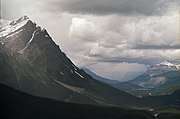
.JPG) Waputik Range seen from the Icefields Parkway | |
| Highest point | |
| Peak | Mount Balfour |
| Elevation | 3,284 m (10,774 ft) |
| Dimensions | |
| Length | 19 km (12 mi) [1] |
| Width | 19 km (12 mi) [1] |
| Area | 235 km2 (91 sq mi) [1] |
| Geography | |
 | |
| Country | Canada |
| Province | Alberta |
| Range coordinates | 51°31′59″N 116°22′02″W [2] |
| Parent range | Waputik Mountains |
The Waputik Range should not be confused with the much larger Waputik Mountains which encompasses this range and other peaks along the Continental Divide in Yoho National Park.
Peaks
- Howse Peak 3,295 m or 10,810 ft, highest in the Waputik Mountains
- Mount Balfour 3284m
- Mount Patterson 3191m
- Mount Baker 3180m
- Mont des Poilus 3166m
- Mount Gordon 3161m
- The President 3123m
- Caldron Peak 2909m
- Wapta Mountain 2782m
- Waputik Peak 2755m
- Pulpit Peak 2720m
Gallery
 Waputik Range
References
- "Waputik Range". Peakbagger.com. Retrieved 2013-06-08.
- "Waputik Range". Geographical Names Data Base. Natural Resources Canada. Retrieved 2013-06-08.
- Boles, Glen W.; Laurilla, Roger W.; Putnam, William L. (2006). Canadian Mountain Place Names. Vancouver: Rocky Mountain Books. p. 264. ISBN 978-1-894765-79-4.
This article is issued from Wikipedia. The text is licensed under Creative Commons - Attribution - Sharealike. Additional terms may apply for the media files.