Fernie, British Columbia
Fernie is a city in the Elk Valley area of the East Kootenay region of southeastern British Columbia, Canada, located on BC Highway 3 on the eastern approaches to the Crowsnest Pass through the Rocky Mountains. Founded in 1898 and incorporated as the City of Fernie in July 1904, the municipality has a population of over 5,000[1] with an additional 2,000[2] outside city limits in communities under the jurisdiction of the Regional District of East Kootenay. A substantial seasonal population swells the city during the winter months.
Fernie | |
|---|---|
| The Corporation of the City of Fernie | |
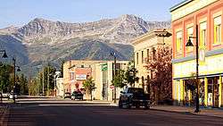 Downtown Fernie, looking south | |
 Flag | |
| Motto(s): "In montibus ad flumen" (Latin) "In the mountains by the river" | |
 Fernie Location of Fernie in British Columbia | |
| Coordinates: 49°30′15″N 115°03′46″W | |
| Country | |
| Province | |
| Region | Elk Valley/East Kootenay |
| Regional District | Regional District of East Kootenay (RDEK) |
| Established | 1904 |
| Government | |
| • City Mayor | Ange Qualliza |
| • Governing body | Fernie City Council |
| • MP | Rob Morrison (politician) |
| • MLA | Tom Shypitka |
| Area | |
| • City | 13.50 km2 (5.21 sq mi) |
| Elevation | 1,010 m (3,314 ft) |
| Population (2016) | |
| • City | 5,249 Ranked 692nd |
| • Metro | 7,192 |
| Time zone | UTC-7 (Mountain Standard (MST)) |
| • Summer (DST) | UTC-6 (Mountain Daylight (MDT)) |
| Postal code span | V0B 1M(0–6) |
| Area code(s) | 250 / 778 / 236 |
| Highways | |
| Website | City of Fernie Fernie Travel & Tourism |
Fernie lies on the Elk River, along Canada's southernmost east-west transportation corridor through the Rockies that crosses the range via the Crowsnest Pass, 40 kilometres (25 miles) to the east. As the largest and longest-established community between Cranbrook and Lethbridge, Fernie serves as a minor regional centre, particularly for its fellow Elk Valley communities.
Geography
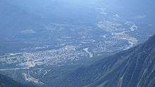
Fernie is the only city-class municipality in Canada that is fully encircled by the Rocky Mountains. The townsite was laid out in the crook of a doglegged glacial valley that today is drained by the Elk River. Three tributaries of the Elk—Coal, Lizard, and Fairy Creeks—rise in its side valleys and join the Elk either within or in close proximity to the townsite.
To the north of the city lie Mount Fernie, Mount Klauer, The Three Sisters and Mount Proctor. To the northeast is Mount Hosmer, to the east is Fernie Ridge, to the southeast is Morrissey Ridge (and its notable outcropping, Castle Mountain) and to the southwest are the various peaks of the Lizard Range. Fernie gives the name to the Jurassic-Age Fernie Formation. The Lizard Range is home to Fernie Alpine Resort, one of the largest ski resorts in Canada, and Island Lake Catskiing, a resort.
Mining history
While the slopes of the mountains are the present focus of economic activity, until comparatively recently residents of the area were more interested in the mountains' innards. The vast Crowsnest Coal Field lies just to the east of the city, and Fernie owes its origins to nineteenth-century prospector William Fernie, who established the coal industry that continues to exist to this day. Acting on pioneer Michael Phillips' twin discoveries of coal and the Crowsnest Pass a few years earlier, Fernie founded the Crows Nest Pass Coal Company in 1897 and established a temporary encampment near Coal Creek. The Canadian Pacific Railway arrived in the valley the following year, and a townsite emerged parallel to the railway line slightly north of the initial encampment, or "Old Town."[3]:80
On May 23, 1902, a coal mine explosion killed 109 miners at the Crow's Nest Coal Mining Company.[4] The disaster, one of the worst mining accidents in Canadian history, is largely forgotten in Fernie and overlooked by local historians after more than a century. During World War One, an internment camp for prisoners of war was set up at rented premises in Fernie from June 1915 to October 1918.[5]
Underground coal mines were dug 10 kilometres (6.2 miles) away from the townsite in the narrow Coal Creek valley and until 1960 a small satellite community was known as Coal Creek stood adjacent to them. A variety of other mines were sunk into the coal fields in a fifty-kilometer radius in the following two decades. No mining was ever carried out in Fernie proper; coking of Coal Creek coal was carried out at the townsite, but otherwise, the town developed into an administrative and commercial centre for the burgeoning industry. Forestry played a smaller role in the local economy and a local brewery produced Fernie Beer from Brewery Creek (mountain spring water).
Like most single-industry towns, Fernie endured several boom-and-bust cycles throughout the twentieth century, generally tied to the global price of coal. The mines at Coal Creek closed permanently by 1960 and the focus of mining activity shifted to Michel and Natal about twenty-five kilometres (16 miles) upriver, which sat on a more productive portion of the Crowsnest Coal Field. Kaiser Resources opened immense open-pit mines there in the 1970s to meet new metallurgical coal contracts for the Asian industrial market, predominantly for use in blast furnaces. Fernie would remain an important residential base for mine labour, along with the new communities of Sparwood and Elkford that sprang up much closer to these new mines. Today, Teck Resources operates all five open-pit mines, shipping out unit trains (often with more than 100 cars) along the Canadian Pacific Railway through Fernie to the Pacific Coast, where the coal is loaded onto freighters at Roberts Bank Superport in Delta.
Architectural heritage
After a disastrous fire leveled much of the downtown core in 1904, the fledgling municipal government passed an ordinance requiring all buildings in the area to be built of 'fireproof' materials like brick and stone. Consequently, a new city centre rose from the ashes sporting brick buildings along broad avenues that would have looked more at home in a sedate and refined Victorian city than a rough-and-tumble frontier coal town. They were short-lived, however, as a second, larger inferno swept through the city on August 1, 1908. Whipped up by sudden winds, a nearby forest fire burnt its way into a lumber yard on the edge of the community and sparked a Dresden-style firestorm that melted brick and mortar and essentially erased the entire city in an afternoon. There were few casualties however and for a second time, a stately brick downtown core rose from the ashes. Today, these historic buildings, most of which still stand, are a treasured and distinctive feature of the community.
Sports
Summer in Fernie is generally far quieter than the winter months, though mountain biking, fly fishing and golf are increasingly important tourist draws.
| Club | League | Sport | Venue | Established | Championships |
|---|---|---|---|---|---|
| Fernie Ghostriders | Ice hockey | Fernie Memorial Arena |
Fernie Memorial Arena disaster
On October 17, 2017, there was an ammonia leak at the Fernie Memorial Arena which killed three workers (two City of Fernie employees and one CIMCO refrigeration employee from Calgary) during the Ghostriders' regular season. Because of this tragedy, the City of Fernie declared a state of emergency and people had to evacuate the area for days. The 'Riders were relocated because of this to the Elk Valley Leisure Centre in Sparwood, British Columbia during the 2017–18 KIJHL season until the City of Fernie decided what to do.[6][7] The City of Fernie decided to replace ammonia for a synthetic refrigerant prior to the 2018–19 KIJHL season and moved the team back to the Fernie Memorial Arena.[8]
Notable people
The following people were born, raised in or reside in Fernie:
- Angie Abdou, Canadian fiction writer
- Emily Brydon, retired Olympic alpine skier
- Shane Churla, Stanley Cup finalist
- James Gladstone, the first Status Indian to be appointed to the Senate of Canada
- Ivy Granstrom, blind Canadian Masters athlete
- George Wayne Haddad, Canadian politician and Fernie's past MLA
- Cal Hockley, retired gold medal winning hockey player
- Frank Hughes, retired NHL and WHA hockey player
- Craig Kelly, professional snowboarder
- Jason Krog, Stanley Cup finalist
- Florence Lassandro, Italian-Canadian bootlegger
- David LeNeveu, Stanley Cup finalist
- Alex Lifeson, guitarist of Rush
- Bill Lindsay, Stanley Cup finalist
- Eric Munn, sixth Bishop of Caledonia
- Emilio Picariello, Italian-Canadian bootlegger
- Danielle Poleschuk, Canadian freestyle skier
- Garth Rizzuto, retired NHL and WHA hockey player
- William Roderick Ross, Canadian politician and Fernie's MLA
- Darren Servatius, retired AAHL and ECHL defencemen
- Dan Smith, retired NHL hockey player
- Stanford Smith, Stanley Cup champion
- Alfred Stork, Canadian politician and Fernie's past mayor and MLA
- Tom Uphill, Canadian politician and Fernie's past mayor and MLA
Local media
Newspapers
- e-know - East Kootenay news online weekly
- Fernie Fix - monthly glossy magazine
- The Free Press - weekly paper
Radio stations
- 107.9 FM - 2Day FM, modern adult contemporary
- 103.5 FM - CJAY 92, active rock
- 99.1 FM - The Drive, active rock
- 97.7 FM - CBC Radio One, public news/talk
- 92.7 FM - B104, country
Cable television
Shaw Communications operates a cable system serving Fernie. The cable system offers most major channels from Vancouver and Calgary, as well as local programming on Shaw TV channel 10.
Schools and colleges
School District 5 Southeast Kootenay operates the following public schools in Fernie:
- Isabella Dicken Elementary School (Grades K-6)
- Fernie Secondary School (Grades 7-12)
The Conseil scolaire francophone de la Colombie-Britannique operates one Francophone school: école Sophie-Morigeau primary school.[9][10]
Private schools:
- The Fernie Academy (Grades K-12)
Post-secondary:
Demographics
| Canada 2016 Census | Population | % of Total Population | |
|---|---|---|---|
| Visible minority group Source:[11] |
Chinese | 30 | 0.6% |
| South Asian | 25 | 0.5% | |
| Black | 0 | 0% | |
| Filipino | 60 | 1.2% | |
| Latin American | 25 | 0.5% | |
| Arab | 0 | 0% | |
| Southeast Asian | 0 | 0% | |
| West Asian | 0 | 0% | |
| Korean | 10 | 0.2% | |
| Japanese | 15 | 0.3% | |
| Other visible minority | 0 | 0% | |
| Mixed visible minority | 10 | 0.2% | |
| Total visible minority population | 175 | 3.4% | |
| Aboriginal group Source:[12] | First Nations | 125 | 2.4% |
| Métis | 175 | 3.4% | |
| Inuit | 0 | 0% | |
| Total Aboriginal population | 300 | 5.8% | |
| European Canadian | 4,680 | 90.8% | |
| Total population | 5,155 | 100% | |
Climate
Fernie has a cool and wet humid continental climate (Köppen Dfb) with warm summer days, cool summer nights along with cold and snowy winters. Influenced by chinook winds and being to the west of the continent, Fernie's winters are mild for its latitude in North America, although the climate is a lot more continental than coastal British Columbia.
| Climate data for Fernie | |||||||||||||
|---|---|---|---|---|---|---|---|---|---|---|---|---|---|
| Month | Jan | Feb | Mar | Apr | May | Jun | Jul | Aug | Sep | Oct | Nov | Dec | Year |
| Record high °C (°F) | 15.0 (59.0) |
15.5 (59.9) |
21.0 (69.8) |
28.9 (84.0) |
33.0 (91.4) |
36.1 (97.0) |
36.0 (96.8) |
36.0 (96.8) |
33.0 (91.4) |
28.0 (82.4) |
18.3 (64.9) |
12.5 (54.5) |
36.1 (97.0) |
| Average high °C (°F) | −0.7 (30.7) |
1.6 (34.9) |
6.5 (43.7) |
11.9 (53.4) |
16.9 (62.4) |
20.6 (69.1) |
25.1 (77.2) |
25.1 (77.2) |
19.3 (66.7) |
11.6 (52.9) |
2.9 (37.2) |
−1.9 (28.6) |
11.6 (52.9) |
| Daily mean °C (°F) | −5.2 (22.6) |
−3.8 (25.2) |
0.8 (33.4) |
5.4 (41.7) |
9.9 (49.8) |
13.6 (56.5) |
16.8 (62.2) |
16.3 (61.3) |
11.3 (52.3) |
5.5 (41.9) |
−1.1 (30.0) |
−6.1 (21.0) |
5.3 (41.5) |
| Average low °C (°F) | −9.6 (14.7) |
−9.2 (15.4) |
−4.9 (23.2) |
−1.1 (30.0) |
2.8 (37.0) |
6.6 (43.9) |
8.4 (47.1) |
7.4 (45.3) |
3.3 (37.9) |
−0.7 (30.7) |
−5.0 (23.0) |
−10.1 (13.8) |
−1.0 (30.2) |
| Record low °C (°F) | −39.4 (−38.9) |
−40.0 (−40.0) |
−32.8 (−27.0) |
−20.0 (−4.0) |
−11.0 (12.2) |
−2.2 (28.0) |
0.0 (32.0) |
−2.0 (28.4) |
−18.3 (−0.9) |
−24.4 (−11.9) |
−32.2 (−26.0) |
−41.7 (−43.1) |
−41.7 (−43.1) |
| Average precipitation mm (inches) | 139.3 (5.48) |
88.0 (3.46) |
97.8 (3.85) |
92.8 (3.65) |
91.8 (3.61) |
110.0 (4.33) |
67.0 (2.64) |
51.9 (2.04) |
75.8 (2.98) |
115.7 (4.56) |
179.1 (7.05) |
117.7 (4.63) |
1,227.1 (48.31) |
| Average rainfall mm (inches) | 55.8 (2.20) |
41.5 (1.63) |
60.6 (2.39) |
80.0 (3.15) |
88.8 (3.50) |
109.8 (4.32) |
67.0 (2.64) |
51.9 (2.04) |
75.4 (2.97) |
109.4 (4.31) |
123.0 (4.84) |
39.0 (1.54) |
902.2 (35.52) |
| Average snowfall cm (inches) | 83.5 (32.9) |
46.4 (18.3) |
37.2 (14.6) |
12.9 (5.1) |
3.1 (1.2) |
0.2 (0.1) |
0.0 (0.0) |
0.0 (0.0) |
0.4 (0.2) |
6.4 (2.5) |
56.2 (22.1) |
78.7 (31.0) |
324.9 (127.9) |
| Average precipitation days (≥ 0.2 mm) | 15.0 | 11.0 | 12.8 | 12.5 | 14.5 | 16.1 | 10.0 | 9.2 | 9.2 | 12.5 | 15.0 | 13.3 | 151.0 |
| Average rainy days (≥ 0.2 mm) | 4.9 | 4.4 | 8.6 | 11.2 | 14.2 | 16.1 | 10.0 | 9.2 | 9.2 | 11.7 | 9.2 | 3.6 | 112.1 |
| Average snowy days (≥ 0.2 cm) | 12.0 | 8.2 | 6.4 | 2.7 | 0.7 | 0.0 | 0.0 | 0.0 | 0.1 | 1.6 | 7.7 | 11.4 | 50.7 |
| Source: [13] | |||||||||||||
See also
- Coal Creek, British Columbia, The Ghost Town
- Coal Creek (British Columbia), The Creek
References
- https://www12.statcan.gc.ca/census-recensement/2016/dp-pd/prof/details/page.cfm?Lang=E&Geo1=CSD&Code1=5901012&Geo2=PR&Code2=48&Data=Count&SearchText=Fernie&SearchType=Begins&SearchPR=01&B1=All&TABID=1
- https://www12.statcan.gc.ca/census-recensement/2016/dp-pd/prof/details/Page.cfm?Lang=E&Geo1=CSD&Code1=5901017&Geo2=PR&Code2=59&Data=Count&SearchText=hosmer&SearchType=Begins&SearchPR=01&B1=All
- Akrigg, G.P.V.; Akrigg, Helen B. (1986), British Columbia Place Names (3rd, 1997 ed.), Vancouver: UBC Press, ISBN 0-7748-0636-2
- "Fernie BC Coal Mine Explosion May 1902"
- "Internment Camps in Canada during the First and Second World Wars, Library and Archives Canada".
- http://www.cbc.ca/news/canada/british-columbia/b-c-ice-rink-where-3-people-died-remains-closed-due-to-safety-concerns-1.4366207
- https://vancouversun.com/news/local-news/fernie-rink-still-closed-as-rcmp-investigation-continues-into-deaths-of-three-men
- "Calgary company chosen to replace refrigeration plant at Fernie arena". Calgary. 2018-03-30. Retrieved 2018-07-21.
- "Carte des écoles." Conseil scolaire francophone de la Colombie-Britannique. Retrieved on 22 January 2015.
- Home page. L’école Sophie-Morigeau.
- "Community Profiles from the 2011 Census, Statistics Canada – Census Subdivision". 2.statcan.gc.ca. 6 December 2010. Archived from the original on 10 April 2014. Retrieved 13 April 2013.
- "Aboriginal Peoples – Data table". 2.statcan.ca. 6 October 2010. Retrieved 13 April 2013.
- "Canadian Climate Normals 1981-2010 Station Data". Environment Canada. Retrieved January 15, 2016.
External links
| Wikivoyage has a travel guide for Fernie. |
| Wikisource has the text of the 1920 Encyclopedia Americana article Fernie. |
| Subdivisions |  | |
|---|---|---|
| Communities | ||
| Metro areas and agglomerations |
| |
| Cities |
| |
| ||
| Authority control |
|
|---|