The President
The President is a mountain peak on The President/Vice-President Massif of the President Range, in eastern British Columbia.
| The President | |
|---|---|
_from_Isolated_col_(skiout).jpg) | |
| Highest point | |
| Elevation | 3,123 m (10,246 ft) [1] |
| Prominence | 658 m (2,159 ft) [1] (above Kiwetinok Pass) |
| Coordinates | 51°30′03″N 116°33′43″W [2] |
| Geography | |
 The President | |
| Parent range | President Range Canadian Rockies |
| Topo map | NTS 82N/10 |
| Climbing | |
| First ascent | 1901 by James Outram, Christian Kaufmann and Joseph Pollinger[3] |
| Easiest route | scramble |
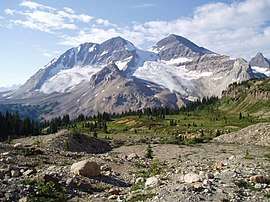
Left to right, The Vice President, President Glacier, and The President
It is just north of Emerald Lake in Yoho National Park, near the Alpine Club of Canada's Stanley Mitchell hut.
History
The President was named Shaugnessy in 1904 by Edward Whymper after Thomas Shaugnessy, the president of the Canadian Pacific Railway.[2] In 1907, the mountain was renamed by the Alpine Club of Canada, after it was discovered that the name had already been used on a mountain in the Selkirks.[1]
Climate
Based on the Köppen climate classification, The President is located in a subarctic climate with cold, snowy winters, and mild summers.[4] Temperatures can drop below −20 C with wind chill factors below −30 C.
References
- "The President". Bivouac.com. Retrieved 2013-04-28.
- "The President". BC Geographical Names. Retrieved 2013-04-28.
- "The President". PeakFinder.com. Retrieved 2019-12-16.
- Peel, M. C.; Finlayson, B. L. & McMahon, T. A. (2007). "Updated world map of the Köppen−Geiger climate classification". Hydrol. Earth Syst. Sci. 11: 1633–1644. ISSN 1027-5606.
External links
This article is issued from Wikipedia. The text is licensed under Creative Commons - Attribution - Sharealike. Additional terms may apply for the media files.