Pukaskwa National Park
Pukaskwa National Park (/ˈpʌkəsɔː/ PUK-ə-saw)[1] is a national park located south of the town of Marathon, Ontario in the Thunder Bay District of northern Ontario, Canada. Established in 1978, Pukaskwa is known for its vistas of Lake Superior and boreal forests. The park covers an area of 1,878 square kilometres (725 sq mi), and protects part of the longest undeveloped shoreline anywhere on the Great Lakes.
| Pukaskwa National Park | |
|---|---|
IUCN category II (national park) | |
 Location of Pukaskwa National Park in Canada | |
| Location | Ontario, Canada |
| Nearest city | Marathon, Ontario |
| Coordinates | 48°14′44″N 85°53′18″W |
| Area | 1,878 km2 (725 sq mi) |
| Established | 1978 |
| Governing body | Parks Canada |
The Hattie Cove Campground is located at the north end of the park and can be accessed via Highway 627, the only road access into the park. There are also a number of backcountry campsites located along the 60 km Coastal Hiking Trail which follows the north shore of Lake Superior. The Coastal Hiking Trail has two suspension bridges; one across the White River at Chigaamiwinigum and one across the Willow River. The Coastal Hiking Trail is part of the long-distance Voyageur Hiking Trail. Backcountry campsites are also located along the Coastal Paddling Route, the White River, and the Pukaskwa River.
Fauna
Black bears, moose, beavers, peregrine falcons, river otters, lynx and timber wolves are found in this park. There was also a small population of woodland caribou but their numbers declined from 30 caribou in the 1970s to about four in 2012 mainly due to wolf predation.[2][3] In early 2017, after previous failures to locate any remaining caribou, researchers turned to advanced thermal imaging technology to survey the area for caribou. This survey revealed caribou are now extirpated from this park.
Climate
The park has a humid continental climate (Dfb) under the Köppen climate classification that is strongly influenced by Lake Superior.
| Climate data for Pukaskwa National Park (1981−2010) | |||||||||||||
|---|---|---|---|---|---|---|---|---|---|---|---|---|---|
| Month | Jan | Feb | Mar | Apr | May | Jun | Jul | Aug | Sep | Oct | Nov | Dec | Year |
| Record high °C (°F) | 6.0 (42.8) |
10.0 (50.0) |
17.0 (62.6) |
27.0 (80.6) |
29.0 (84.2) |
30.7 (87.3) |
30.5 (86.9) |
32.0 (89.6) |
25.3 (77.5) |
21.0 (69.8) |
16.5 (61.7) |
9.2 (48.6) |
32.0 (89.6) |
| Average high °C (°F) | −7.7 (18.1) |
−4.1 (24.6) |
0.6 (33.1) |
7.2 (45.0) |
13.5 (56.3) |
17.2 (63.0) |
19.5 (67.1) |
20.4 (68.7) |
15.8 (60.4) |
8.8 (47.8) |
1.9 (35.4) |
−4.2 (24.4) |
7.4 (45.3) |
| Daily mean °C (°F) | −13.5 (7.7) |
−10.1 (13.8) |
−5.3 (22.5) |
1.9 (35.4) |
7.8 (46.0) |
11.8 (53.2) |
14.4 (57.9) |
15.6 (60.1) |
11.6 (52.9) |
5.0 (41.0) |
−1.8 (28.8) |
−9.1 (15.6) |
2.4 (36.3) |
| Average low °C (°F) | −19.2 (−2.6) |
−16.1 (3.0) |
−11.1 (12.0) |
−3.4 (25.9) |
2.4 (36.3) |
6.3 (43.3) |
9.3 (48.7) |
10.7 (51.3) |
7.3 (45.1) |
1.2 (34.2) |
−5.5 (22.1) |
−13.9 (7.0) |
−2.7 (27.1) |
| Record low °C (°F) | −40 (−40) |
−39 (−38) |
−35 (−31) |
−21 (−6) |
−7.5 (18.5) |
−4.5 (23.9) |
−4.5 (23.9) |
−2.0 (28.4) |
−7 (19) |
−11.5 (11.3) |
−28.5 (−19.3) |
−39.5 (−39.1) |
−40 (−40) |
| Average precipitation mm (inches) | 60.4 (2.38) |
32.7 (1.29) |
36.7 (1.44) |
41.7 (1.64) |
72.4 (2.85) |
84.5 (3.33) |
95.2 (3.75) |
75.9 (2.99) |
106.0 (4.17) |
90.8 (3.57) |
80.0 (3.15) |
59.8 (2.35) |
836.2 (32.92) |
| Average rainfall mm (inches) | 0.64 (0.03) |
1.8 (0.07) |
10.5 (0.41) |
34.3 (1.35) |
71.6 (2.82) |
84.5 (3.33) |
95.2 (3.75) |
75.8 (2.98) |
105.9 (4.17) |
83.5 (3.29) |
47.7 (1.88) |
5.1 (0.20) |
616.5 (24.27) |
| Average snowfall cm (inches) | 59.8 (23.5) |
30.9 (12.2) |
26.3 (10.4) |
7.3 (2.9) |
0.88 (0.35) |
0.0 (0.0) |
0.0 (0.0) |
0.09 (0.04) |
0.13 (0.05) |
7.3 (2.9) |
32.3 (12.7) |
54.7 (21.5) |
219.7 (86.5) |
| Average precipitation days (≥ 0.2 mm) | 14.6 | 10.9 | 9.0 | 8.4 | 13.3 | 13.6 | 15.6 | 14.3 | 17.2 | 17.6 | 15.6 | 13.9 | 164 |
| Average rainy days (≥ 0.2 mm) | 0.42 | 0.58 | 1.8 | 7.3 | 12.9 | 13.6 | 15.6 | 14.2 | 17.2 | 16.2 | 7.6 | 1.0 | 108.4 |
| Average snowy days (≥ 0.2 cm) | 14.0 | 9.6 | 6.8 | 2.7 | 0.33 | 0.0 | 0.0 | 0.08 | 0.07 | 2.2 | 9.3 | 13.4 | 58.4 |
| Source: Environment Canada[4] | |||||||||||||
Rivers in the park include the:
- Pukaskwa River
- Cascade River
- North Swallow River
- Swallow River
- White River
- Willow River
The Pic River enters Lake Superior just north of the park.
The highest point in the park is the peak of Tip Top Mountain which rises to 641 meters / 2106 feet.[5]
Thousand year old rock structures known as Pukaskwa Pits which were created by the original inhabitants of this area can be found on many of the park's cobblestone beaches.
The most recent State of the Park Report for Pukaskwa National Park was published in 2008.
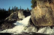 Cascade River Falls |
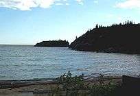 Horseshoe Bay on Lake Superior |
See also
| Wikimedia Commons has media related to Pukaskwa National Park. |
External links
| Wikivoyage has a travel guide for Pukaskwa National Park. |
- Official Parks Canada site
- Watch the short documentary by Bill Mason Pukaskwa National Park
- 2008 State of the Park Report
Footnotes
- "The Pukaskwa Coastal Trail: a hike that's breathtaking in more ways than one". The Independent. March 31, 2016. Retrieved September 17, 2017.
- Foster & Harris 2012, p. ii.
- Bergerud 2007, p. 46.
- "Pukaskwa National park". Canadian Climate Normals 1981–2010. Environment Canada. Retrieved September 29, 2013.
- Tip Top Mountain - Peakbagger.com
References
- Bergerud, Arthur T. (2007), "The need for the management of wolves — an open letter" (PDF), Rangifer, Special Issue (17): 39–49, archived from the original (PDF) on 22 April 2016, retrieved 23 September 2014
- Foster, Robert F.; Harris, Allan G. (19 July 2012), Environmental Assessment for the Marathon PGM-Cu Project at Marathon, Ontario (PDF), Supporting Information Document No. 26: Assessment of impacts on Woodland Caribou, Thunder Bay, Ontario: Stillwater Canada Inc., retrieved 23 September 2014 Pukaskwa National Parks’ population has "declined from approximately 30 caribou in the 1970s to an estimated four currently, largely due to predation by wolves and possibly black bears."
| National Parks |
|
|---|---|
| Marine Conservation Areas | |
| National Landmarks | |
| |
| National parks | 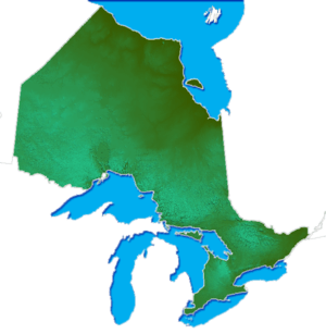 | |
|---|---|---|
| Provincial parks | ||
| Conservation areas |
| |
| UNESCO Biosphere Reserves |
| |
| National Historic Sites | ||
| Greenbelts | ||
| Former parks | ||
| ||