Wapta Mountain
Wapta Mountain is a mountain located in the Canadian Rocky Mountains between Emerald Lake and Yoho Valley in Yoho National Park, British Columbia, Canada. It stands just north of the ridge containing the Burgess Shale fossil beds. Along with The Vice President and Mount Burgess, Wapta Mountain forms the backdrop to Emerald Lake, and marks the southern end of the President Range.
| Wapta Mountain | |
|---|---|
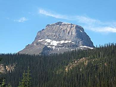
 Wapta Mountain marks the end of Fossil Ridge | |
| Highest point | |
| Elevation | 2,778 m (9,114 ft) [1][2] |
| Coordinates | 51°27′05″N 116°28′39″W [3] |
| Geography | |
 Wapta Mountain | |
| Parent range | President Range |
| Topo map | NTS 082N08 |
| Climbing | |
| First ascent | 1901[4] |
In 1901, James Outram, J. H. Scattergood, and their guide C. Bohren, became the first people to ascend Wapta Mountain.[4] Wapta Mountain overlooks Takakkaw Falls (1,247 feet), the second tallest waterfall in western Canada. The word "Wapta" means "river" in Stoney language.[5]
References
- "Wapta Mountain". PeakFinder.com. Retrieved 2019-08-17.
- Lake Louise & Yoho (Map). 1:50000. Cochrane, AB, CA: Gem Trek Publishing. 2001. § C2.
- "Wapta Mountain". BC Geographical Names. Retrieved 2016-07-02.
- "Wapta Mountain". Bivouac.com. Retrieved 2016-07-02.
- British Columbia official names
Wapta Mountain
This article is issued from Wikipedia. The text is licensed under Creative Commons - Attribution - Sharealike. Additional terms may apply for the media files.