Palliser Range
The Palliser Range is a mountain range of the Canadian Rockies that lies in the extreme southeast corner of Banff National Park, Alberta, Canada.
| Palliser Range | |
|---|---|
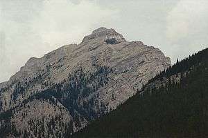 Mount Aylmer, August 1994 | |
| Highest point | |
| Peak | Mount Aylmer |
| Elevation | 3,162 m (10,374 ft) [1] |
| Listing | Mountains of Alberta |
| Geography | |
 Location of Palliser Range in Alberta  Palliser Range (Canada) | |
| Location | Banff National Park Alberta, Canada |
| Range coordinates | 51°23′N 115°34′W [2] |
| Parent range | Canadian Rockies |
| Borders on | Bare Range |
| Topo map | NTS 82O/05[2] |
The Palliser Range is part of the East Banff Ranges of the Central Front Canadian Rockies.[3]
Lake Minnewanka marks the southern boundary of the range while the Bare Range marks the northern boundary. Its eastern reaches are marked by the Blackrock Mountain of the Ghost River Area. The range was named by the Palliser expedition as it appears on one of the maps produced by the expedition. The range gives the name to the Palliser Formation, a stratigraphical unit prominently featured in the mountains of this range.
This range includes the following mountains and peaks:
| Mountain/Peak | Elevation | |
|---|---|---|
| Mount Aylmer | 3,162 m (10,374 ft) | |
| Puma Peak | 3,120 m (10,236 ft) | |
| Revenant Mountain | 3,065 m (10,056 ft) | |
| Apparition Mountain | 3,002 m (9,849 ft) | |
| Mount Astley | 2,869 m (9,413 ft) |
See also
References
- "Mount Aylmer". PeakFinder.com. Retrieved 2019-09-18.
- "Palliser Range". Geographical Names Data Base. Natural Resources Canada. Retrieved 2019-09-18.
- "Palliser Range". Peakbagger.com. Retrieved 2019-09-18.
This article is issued from Wikipedia. The text is licensed under Creative Commons - Attribution - Sharealike. Additional terms may apply for the media files.