Yarraman, Queensland
Yarraman is a rural town and locality in the Toowoomba Region, Queensland, Australia.[2][3] In the 2016 census, Yarraman had a population of 1,064 people.[1]
| Yarraman Queensland | |||||||||||||||
|---|---|---|---|---|---|---|---|---|---|---|---|---|---|---|---|
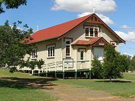 Our Lady of Dolours Roman Catholic church in Yarraman | |||||||||||||||
 Yarraman | |||||||||||||||
| Coordinates | 26.8411°S 151.9841°E | ||||||||||||||
| Population | 1,064 (2016 census)[1] | ||||||||||||||
| • Density | 8.274/km2 (21.429/sq mi) | ||||||||||||||
| Postcode(s) | 4614 | ||||||||||||||
| Elevation | 407 m (1,335 ft) | ||||||||||||||
| Area | 128.6 km2 (49.7 sq mi) | ||||||||||||||
| Time zone | AEST (UTC+10:00) | ||||||||||||||
| Location |
| ||||||||||||||
| LGA(s) | Toowoomba Region | ||||||||||||||
| County | Cavendish | ||||||||||||||
| Parish | Cooyar | ||||||||||||||
| State electorate(s) | Nanango | ||||||||||||||
| Federal Division(s) | Maranoa | ||||||||||||||
| |||||||||||||||
Geography
Yarraman is located 181 kilometres (112 mi) northwest of the state capital, Brisbane on the junction of the New England and D'Aguilar highways.
Yarraman is set in a fertile valley and produces timber, grain and beef and dairy goods, which it exports to larger cities.
Yarraman is surrounded by the various components of the fragmentary Bunya Mountains and Yarraman Important Bird Area which contains the largest remaining population of the vulnerable black-breasted button-quail.[4]
History
The name Yarraman means horse in the Port Jackson Pidgin English spread by Aboriginal stockmen in eastern Australia. It might derive from word yira or yera meaning large teeth.[2]
The creek at Yarraman was used in the 1870s as a place for local graziers and stockmen to meet and trade cattle. The township was established in the late 1870s.[5]
Yarraman Creek Provisional School opened on 17 July 1901. On 1 January 1909 it became Yarraman Creek State School. In 1935 it was renamed Yarraman State School. In 1963 the school expanded to include a secondary department. In 1980 a pre-school was added.[6]
As there were many large hoop pine forests in the area, a timber mill was established in 1910.[5]
Rocky Hill Provisional School opened on 30 October 1924. A new school building was erected and in October 1929 it became Rocky Hill State School.[7] It closed in 1963.[6][8] The building was relocated to Yarraman in the 1960s and has been used for various community purposes. In 2016 it was relocated to the Yarraman Heritage House where it will be restored as classrooms with school displays.[9]
The Sacred Heart Convent was completed in 1945. The Sisters of Mercy opened a boarding school for boys in 1946. It closed in 1966. The building is now used as the Yarraman Heritage House.[10]
The town was connected to Brisbane and Ipswich by railway in 1913.[5] The railway line was closed in 1988.[11]
The Yarraman Library opened in 1982 and had a major refurbishment in 2016.[12]
Amenities
The Yarraman Library and Post Office are located on the corner of Toomey and Douglas Streets, and offer access to wireless internet.[16][17] The Toowoomba Regional Council refurbished the library in 2016 including new furnishings, paint, and an accessible parking space and toilet.[18]
The Yarraman Memorial Pool is located in Margaret Street, on the New England Highway.[19]
The Blackbutt Yarraman branch of the Queensland Country Women's Association meets at the QCWA Hall at 65 Coulson Street in Blackbutt.[20]
It has a community radio station Wild Horse FM 99.7.[21]
Yarraman has three churches: St Philip's Anglican Church, Our Lady of Dolours Catholic Church, and Calvary Lutheran church.
Education
Yarraman State School is a government primary and secondary (Prep-9) school for boys and girls at 17 John Street (26.8415°S 151.9767°E).[22][23] In 2017, the school had an enrolment of 163 students with 15 teachers (13 full-time equivalent) and 19 non-teaching staff (11 full-time equivalent).[24]
The nearest secondary school providing Years 10 to 12 education is in Nanango.[25]
Military History
During World War 2, Yarraman was the location of RAAF No.21 Inland Aircraft Fuel Depot (IAFD), completed in 1942 and closed on 29 August 1944. Usually consisting of 4 tanks, 31 fuel depots were built across Australia for the storage and supply of aircraft fuel for the RAAF and the US Army Air Forces at a total cost of £900,000 ($1,800,000).[26]
References
- Australian Bureau of Statistics (27 June 2017). "Yarraman (SSC)". 2016 Census QuickStats. Retrieved 20 October 2018.

- "Yarraman - town in Toowoomba Region (entry 38514)". Queensland Place Names. Queensland Government. Retrieved 17 November 2019.
- "Yarraman - locality in Toowoomba Region (entry 48105)". Queensland Place Names. Queensland Government. Retrieved 17 November 2019.
- "IBA: Bunya Mountains & Yarraman". Birdata. Birds Australia. Archived from the original on 6 July 2011. Retrieved 8 June 2011.
- South Burnett Net: Yarraman Archived 14 April 2011 at the Wayback Machine, accessed 17 Jan 2010
- Queensland Family History Society (2010), Queensland schools past and present (Version 1.01 ed.), Queensland Family History Society, ISBN 978-1-921171-26-0
- "To Cost £70,000". The Telegraph (17, 588). Queensland, Australia. 18 April 1929. p. 5. Retrieved 28 November 2019.
- "ROCKY HILL STATE SCHOOL". The Brisbane Courier (22, 390). Queensland, Australia. 31 October 1929. p. 23. Retrieved 28 November 2019 – via National Library of Australia.
- "Old School On The Move ... Again". southburnett.com.au. 18 July 2016. Archived from the original on 27 November 2019. Retrieved 27 November 2019.
- "Yarraman Heritage House". Brown Signs. 9 June 2018. Archived from the original on 27 November 2019. Retrieved 27 November 2019.
- Queensland Places: Yarraman Archived 21 November 2010 at the Wayback Machine, accessed 17 Jan 2010
- "Public Libraries Statistical Bulletin 2016-17" (PDF). Public Libraries Connect. State Library of Queensland. November 2017. p. 16. Archived (PDF) from the original on 30 January 2018. Retrieved 30 January 2018.
- Australian Bureau of Statistics (9 March 2006). "Yarraman (L) (Urban Centre/Locality)". 2001 Census QuickStats. Retrieved 17 January 2010.
- Australian Bureau of Statistics (25 October 2007). "Yarraman (L) (Urban Centre/Locality)". 2006 Census QuickStats. Retrieved 30 December 2007.
- Australian Bureau of Statistics (31 October 2012). "Yarraman, QLD". 2011 Census QuickStats. Retrieved 24 October 2014.
- "Yarraman Library". State Library of Queensland. Archived from the original on 30 January 2018. Retrieved 30 January 2018.
- "Post Office". Archived from the original on 21 January 2016. Retrieved 25 October 2014.
- "Council spends $164,000 to refurbish regional library". The Chronicle. Archived from the original on 30 January 2018. Retrieved 30 January 2018.
- "Yarraman Pool". Archived from the original on 24 October 2014. Retrieved 25 October 2014.
- "Branch Locations". Queensland Country Women's Association. Archived from the original on 26 December 2018. Retrieved 26 December 2018.
- "World Horse FM 99.7". Archived from the original on 17 July 2019. Retrieved 27 November 2019.
- "State and non-state school details". Queensland Government. 9 July 2018. Archived from the original on 21 November 2018. Retrieved 21 November 2018.
- "Yarraman State School". Archived from the original on 31 May 2016. Retrieved 21 November 2018.
- "ACARA School Profile 2017". Archived from the original on 22 November 2018. Retrieved 22 November 2018.
- "Queensland Globe". State of Queensland. Retrieved 27 November 2019.
- Australia. Royal Australian Air Force. Historical Section (1995), Logistics units, AGPS Press, ISBN 978-0-644-42798-2
External links
| Wikimedia Commons has media related to Yarraman, Queensland. |
- History
- "Yarraman". Queensland Places. Centre for the Government of Queensland, University of Queensland.
- Town map of Yarrman, 1979