Applethorpe, Queensland
Applethorpe is a rural town and locality in the Southern Downs Region, Queensland, Australia.[2][3] It is on the border with New South Wales.[4] In the 2016 census, Applethorpe had a population of 511 people.[5] Applethorpe is well known for the production of apples.[6]
| Applethorpe Queensland | |||||||||||||||
|---|---|---|---|---|---|---|---|---|---|---|---|---|---|---|---|
 The Applethorpe Memorial Park | |||||||||||||||
 Applethorpe | |||||||||||||||
| Coordinates | 28°37′0″S 151°58′0″E | ||||||||||||||
| Population | 748 (2006 census)[1] | ||||||||||||||
| • Density | 16.017/km2 (41.48/sq mi) | ||||||||||||||
| Postcode(s) | 4378 | ||||||||||||||
| Area | 46.7 km2 (18.0 sq mi) | ||||||||||||||
| Location |
| ||||||||||||||
| LGA(s) | Southern Downs Region | ||||||||||||||
| State electorate(s) | Southern Downs | ||||||||||||||
| Federal Division(s) | Maranoa | ||||||||||||||
| |||||||||||||||
Geography
The town is positioned on the New England Highway just north of Stanthorpe in the Granite Belt region at an elevation of 872 meters (2,861 ft).[6][7][8]
The Southern railway line passes through the locality from north (The Summit & Glen Niven) to south (Stanthorpe). The town is served by the Applethorpe railway station.[9]
History
The area was originally called Roessler after an early German settler, but the name was changed to Applethorpe (reflecting the apple orchards in the district) in 1915, as part of the anti-German sentiment during World War I.[2][10][11]
In 1910, the establishment of the Four Mile Stanthorpe School was given and the school was opened on 14 September 1911. However, from November 1911 to November 1916, it was called Roesseller State School. However, like the town itself, the school name was changed to Applethorpe State School due to the anti-German sentiment.[12][13]
In December 1910 the Roessler railway station was established at the 200 miles (320 km) point between Thulimbah and Stanthorpe.[14] In September 1916 it was renamed Applethorpe railway station due to anti-German sentiment.[15]
Four Mile State School opened on 14 September 1911. In November 1911 it was renamed Roesseller State School in Nov 1911 and in 1917 it was renamed Applethorpe State School.[16]
Applethorpe Post Office opened around 1919 (a receiving office had been open since 1916) and closed in 1991.[17]
In 2006, Applethorpe had a population of 748; of which, 20% worked in the farming or produce industries.[1]
Climate
During a cold snap in 2007, the town recorded a minimum temperature of −7.7 °C.[7] In July 2010, Applethorpe recorded a minimum of 13.6 °C which was the highest minimum on record ever for that month.[18]
Transport
Applethorpe is accessible by the New England Highway and the 'Fruit Run' Granite Tourist Drive.[19] Crisps Coaches also runs regular services to Applethorpe from Brisbane, Toowoomba, and other cities in the area.[20]
Amenities
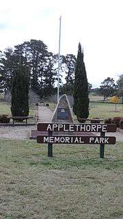
The Applethorpe Memorial Park on Ann Street commemorates those who served in defence of Australia.[21]
Education
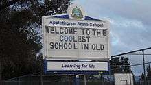
Applethorpe State School is a government primary (Prep-6) school for boys and girls at 25576 New England Highway (28.6125°S 151.9553°E).[22][23] In 2017, the school had an enrolment of 38 students with 4 teachers (3 full-time equivalent) and 5 non-teaching staff (3 full-time equivalent).[24]
References
- "Amiens, Thulimbah, Applethorpe District". Queensland Places. Retrieved 29 May 2012.
- "Applethorpe - town in Southern Downs Region (entry 697)". Queensland Place Names. Queensland Government. Retrieved 5 November 2019.
- "Applethorpe - locality in Southern Downs Region (entry 45906)". Queensland Place Names. Queensland Government. Retrieved 5 November 2019.
- "Queensland Globe". State of Queensland. Retrieved 6 May 2020.
- Australian Bureau of Statistics (27 June 2017). "Applethorpe (SSC)". 2016 Census QuickStats. Retrieved 20 October 2018.

- Applethorpe, Queensland Archived 7 September 2008 at the Wayback Machine. About Australia.
- "Temperatures hit new low". The Courier Mail. News Queensland. 19 July 2007. Retrieved 20 June 2011.
- "Climate statistics for Applethorpe, Australia". Bureau of Meteorology. Retrieved 25 January 2015.
- "Queensland Globe". State of Queensland. Retrieved 11 March 2020.
- "Change of Name". The Brisbane Courier. National Library of Australia. 11 September 1916. p. 11. Retrieved 16 March 2014.
- "NOMENCLATURE OF QUEENSLAND.—11". The Courier-Mail. Brisbane: National Library of Australia. 11 October 1935. p. 12. Retrieved 16 March 2014.
- "Opening and closing dates of Queensland Schools". Queensland Government. Retrieved 18 April 2019.
- "Agency ID11000, Applethorpe State School". Queensland State Archives. Retrieved 5 June 2015.
- "Naming Railway Stations". The Brisbane Courier. Queensland, Australia. 24 December 1910. p. 4. Retrieved 12 March 2020 – via Trove.
- "Change of Name". The Brisbane Courier. Queensland, Australia. 11 September 1916. p. 11. Retrieved 12 March 2020 – via Trove.
- Queensland Family History Society (2010), Queensland schools past and present (Version 1.01 ed.), Queensland Family History Society, ISBN 978-1-921171-26-0
- Premier Postal History. "Post Office List". Premier Postal Auctions. Retrieved 10 May 2014.
- "Rainy send-off for July". The Warwick Newspaper. 2 August 2010. Retrieved 20 June 2011.
- "Applethorpe". Southern Queensland County. Retrieved 16 April 2019.
- "Crisps Coaches - Home". Crisps Coaches. Retrieved 16 April 2019.
- "Applethorpe Memorial Park". Monument Australia. Retrieved 5 June 2015.
- "State and non-state school details". Queensland Government. 9 July 2018. Archived from the original on 21 November 2018. Retrieved 21 November 2018.
- "Applethorpe State School". Retrieved 21 November 2018.
- "ACARA School Profile 2017". Archived from the original on 22 November 2018. Retrieved 22 November 2018.
Further reading
- Applethorpe State School (1961), Golden jubilee, 1911-1961
- Applethorpe State School (1986), Applethorpe State School 75th anniversary 1911-1986, Applethorpe State School, retrieved 5 June 2015
External links
![]()