Boodua, Queensland
Boodua is a locality in the Toowoomba Region local government area on the Darling Downs in southern Queensland, Australia.[2] At the 2016 Australian census, Boodua had a population of 93.[1]
| Boodua Queensland | |||||||||||||||
|---|---|---|---|---|---|---|---|---|---|---|---|---|---|---|---|
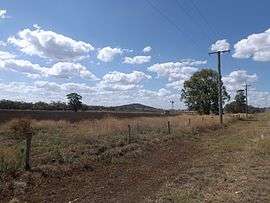 Fields along Kingsthorpe Haden Road | |||||||||||||||
 Boodua | |||||||||||||||
| Coordinates | 27°22′S 151°49′E | ||||||||||||||
| Population | 93 (2016 census)[1] | ||||||||||||||
| Postcode(s) | 4401 | ||||||||||||||
| LGA(s) | Toowoomba Region | ||||||||||||||
| State electorate(s) | Condamine | ||||||||||||||
| Federal Division(s) | Groom | ||||||||||||||
| |||||||||||||||
Geography
Part of the eastern and southern boundary of Boodua follows Oakey Creek, a tributary of the Condamine River. The predominate land use is agriculture.
History
The name originates from a railway station on the Haden railway line and is a native word for a species of hawk.[3]
The Darling Downs Co-operative Dairy Association operated a cheese factory at Boodua between 1926 and 1950. The Boodua State School was open between 1908 and 1962. The area was once part of the Shire of Rosalie until it was merged into the Toowoomba Region in 2008.
References
- Australian Bureau of Statistics (27 June 2017). "Boodua (State Suburb)". 2016 Census QuickStats. Retrieved 25 March 2018.

- "Boodua - locality (entry 47894)". Queensland Place Names. Queensland Government. Retrieved 25 June 2017.
- "NOMENCLATURE OF QUEENSLAND.–49". The Courier-Mail. Brisbane: National Library of Australia. 25 November 1935. p. 10. Retrieved 13 November 2014.
External links
![]()