Aubigny, Queensland
Aubigny is a rural town and locality in the Toowoomba Region, Queensland, Australia.[2][3] In the 2016 census, Aubigny had a population of 254 people.[1]
| Aubigny Queensland | |||||||||||||||
|---|---|---|---|---|---|---|---|---|---|---|---|---|---|---|---|
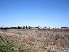 Fields along Oakey Crosshill Road, 2014 | |||||||||||||||
 Aubigny | |||||||||||||||
| Coordinates | 27.5230°S 151.6463°E | ||||||||||||||
| Population | 254 (2016 census)[1] | ||||||||||||||
| • Density | 4.425/km2 (11.46/sq mi) | ||||||||||||||
| Postcode(s) | 4401 | ||||||||||||||
| Elevation | 430 m (1,411 ft) | ||||||||||||||
| Area | 57.4 km2 (22.2 sq mi) | ||||||||||||||
| Time zone | AEST (UTC+10:00) | ||||||||||||||
| LGA(s) | Toowoomba Region | ||||||||||||||
| State electorate(s) | Condamine | ||||||||||||||
| Federal Division(s) | Groom | ||||||||||||||
| |||||||||||||||
Geography
The former locality of Tangkam (27°28′59″S 151°40′00″E) is in the northern part of Aubigny. It took its name from the Tangkam railway station (27.4745°S 151.6725°E) on the Cecil Plains railway line. The name Tangkam is believed to be an Aboriginal word meaning sour.[4]
History
Crosshill State School opened on 9 August 1880 and closed on 1940.[5][6]
Aubigny was at the centre of the Westbrook Homestead area.
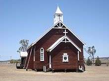
The town lots were offered for sale in the new town of Aubigny in December 1885, but only two lots were sold at that time, one to the Lutheran church and one to the Catholic church.[7] St John's Lutheran Church opened in 1886 and is still operational.[8]
Aubigny Post Office opened around September 1907 (a receiving office had been open since 1894) and closed in 1968.[9]
Aubigny State School opened 24 January 1921 and closed about 27 October 1967.[5][10][11]
The town was serviced by the Cecil Plains railway line between 1915 and 1994.
Tangkam State School opened on 26 November 1918. It closed on 22 January 1961.[5]
At the 2011 census, Aubigny had a population of 386 people.[12]
References
- Australian Bureau of Statistics (27 June 2017). "Aubigny (SSC)". 2016 Census QuickStats. Retrieved 20 October 2018.

- "Aubigny - town in Toowoomba Region (entry 981)". Queensland Place Names. Queensland Government. Retrieved 5 November 2019.
- "Aubigny - locality in Toowoomba Region (entry 47886)". Queensland Place Names. Queensland Government. Retrieved 5 November 2019.
- "Tangkam - neighbourhood (entry 33281)". Queensland Place Names. Queensland Government. Retrieved 27 January 2017.
- Queensland Family History Society (2010), Queensland schools past and present (Version 1.01 ed.), Queensland Family History Society, ISBN 978-1-921171-26-0
- "School for Crosshill". Toowoomba Chronicle And Darling Downs General Advertiser (1464). Queensland, Australia. 11 March 1879. p. 3. Retrieved 23 November 2019 – via National Library of Australia.
- "QUEENSLAND NEWS". The Queenslander. 26 December 1885. p. 1009. Retrieved 27 October 2014 – via National Library of Australia.
- St John's Lutheran Church Aubigny 1886-1986 centennial booklet : centennial celebrations 11th May, 1986, St John's Lutheran Church, 1986, retrieved 27 October 2014
- Premier Postal History. "Post Office List". Premier Postal Auctions. Retrieved 10 May 2014.
- "Opening and closing dates of Queensland Schools". Queensland Government. Retrieved 2 April 2014.
- "Agency ID6349, Aubigny State School". Queensland State Archives. Retrieved 3 April 2014.
- Australian Bureau of Statistics (31 October 2012). "Aubigny". 2011 Census QuickStats. Retrieved 2 April 2014.