Charlton, Queensland
Charlton is a rural locality in the Toowoomba Region, Queensland, Australia, located 13 kilometres (8 mi) west from the Toowoomba city centre off the Warrego Highway.[2] In the 2016 census, Charlton had a population of 120 people.[1]
| Charlton Toowoomba Region, Queensland | |||||||||||||||
|---|---|---|---|---|---|---|---|---|---|---|---|---|---|---|---|
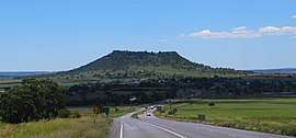 Looking west along the Warrego Highway in Charlton towards Gowrie Mountain, 2015 | |||||||||||||||
 Charlton | |||||||||||||||
| Coordinates | 27.5155°S 151.8486°E | ||||||||||||||
| Population | 120 (2016 census)[1] | ||||||||||||||
| • Density | 7.8/km2 (20.3/sq mi) | ||||||||||||||
| Postcode(s) | 4350 | ||||||||||||||
| Area | 15.3 km2 (5.9 sq mi) | ||||||||||||||
| Location | |||||||||||||||
| LGA(s) | Toowoomba Region | ||||||||||||||
| State electorate(s) | Condamine | ||||||||||||||
| Federal Division(s) | Groom | ||||||||||||||
| |||||||||||||||
Geography
The Western railway line marks the northern boundary of the locality, while the southern boundary roughly follows Dry Creek. The higher of the two peaks of Gowrie Mountain (674 metres above sea level) is in the far west of the locality while the second lower peak (630 metres above sea level) is in the neighbouring locality of Gowrie Mountain.[3]
The Warrego Highway passes through the locality from east to west. The Toowoomba Second Range Crossing road (still being constructed as at November 2018) will intersect the highway with a major interchange in Charlton.[3][4]
History
Gowrie Estate Provisional School opened on 4 July 1898, becoming Gowrie Estate State School on 1 January 1909. In November 1915, it was renamed Charlton State School.[5] It was located at 10834 Warrego Highway. As at 2010, it had an enrolment of 40 children, organised into two classes (Prep-Year 3 and Years 4-7) with 6 teachers (3 full-time equivalent) and 5 non-teaching staff (2 full-time equivalent).[6] It closed on 31 December 2013.[7]
References
- Australian Bureau of Statistics (27 June 2017). "Charlton (SSC)". 2016 Census QuickStats. Retrieved 8 November 2018.

- "Charlton (entry 49644)". Queensland Place Names. Queensland Government. Retrieved 31 August 2015.
- "Queensland Globe". State of Queensland. Retrieved 8 November 2018.
- "Warrego Highway west interchange". Nexus Infrastructure. Archived from the original on 8 November 2018. Retrieved 8 November 2018.
- Queensland Family History Society (2010), Queensland schools past and present (Version 1.01 ed.), Queensland Family History Society, ISBN 978-1-921171-26-0
- "Annual Report 2010". Charlton State School. Archived from the original on 20 March 2012. Retrieved 8 November 2018.
- "Register of Recent School Openings, Closures and Name Changes". Education Queensland. Queensland Government. Archived from the original on 10 March 2018. Retrieved 10 March 2018.
Further reading
- Perring, Patricia; Mulhare, Janice (1998), Charlton State School : the history of our beginnings 1898-1998, Charlton State School, retrieved 8 November 2018
- Charlton State School 90th Anniversary Committee (2003), Charlton State School : 90th anniversary book, [the author], retrieved 8 November 2018