Inglewood, Queensland
Inglewood is a rural town and locality in the Goondiwindi Region, Queensland, Australia.[2][3] In the 2016 census, Inglewood had a population of 954 people.[1] Inglewood is the second largest town in the Goondiwindi Region.
| Inglewood Queensland | |||||||||||||||
|---|---|---|---|---|---|---|---|---|---|---|---|---|---|---|---|
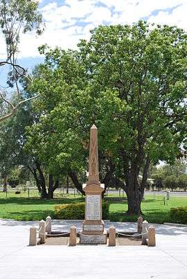 The Anzac Cenotaph in Inglewood's Memorial Park. | |||||||||||||||
 Inglewood | |||||||||||||||
| Coordinates | 28.4161°S 151.08°E | ||||||||||||||
| Population | 954 (2016 census)[1] | ||||||||||||||
| • Density | 2.6708/km2 (6.917/sq mi) | ||||||||||||||
| Established | 1862 | ||||||||||||||
| Postcode(s) | 4387 | ||||||||||||||
| Elevation | 280 m (919 ft) | ||||||||||||||
| Area | 357.2 km2 (137.9 sq mi) | ||||||||||||||
| Time zone | AEST (UTC+10:00) | ||||||||||||||
| Location | |||||||||||||||
| LGA(s) | Goondiwindi Region | ||||||||||||||
| State electorate(s) | Southern Downs | ||||||||||||||
| Federal Division(s) | Maranoa | ||||||||||||||
| |||||||||||||||
The current slogan for the town is 'Catch the country spirit'.
Geography
The town sits on the southern Darling Downs midway between the larger centres of Warwick and Goondiwindi on the Cunningham Highway. It is 150 km (93 mi) south-west of Toowoomba.
It is part of the Border Rivers region of waterways. The confluence of the Macintyre Brook and Canning Creek is sited just north of Inglewood, with the brook running 270° around the town.[4]
Olive growing is a comparatively new industry in the area. Other established industries include sheep and cattle raising, grain growing and timber harvesting. Tobacco growing was common around Inglewood over the last 60 years.
History
Bigambul (also known as Bigambal, Bigumbil, Pikambul, Pikumbul) is an Australian Aboriginal language spoken by the Bigambul people. The Bigambul language region includes the landscape within the local government boundaries of the Goondiwindi Regional Council, including the towns of Goondiwindi, Yelarbon and Texas extending north towards Moonie and Millmerran.[5]
English botanist and explorer Allan Cunningham has been credited with being the first European to discover the Inglewood area. He passed through east of the present township in May 1827. The first settlement in the area was known as Browns Inn[2] and was an important watering point for bullock teams moving west. The inn opened in the late 1850s on the south side of Macintyre Brook.
In April 1862 a town was surveyed by L.F. Landsbergon on the higher northern side of Macintyre Book. Plans were drawn up for the present site and the name changed to Inglewood by Landsberg using a compound word ingol (an Aboriginal word meaning cypress pine) and the English word wood referring to a clump of trees on the northern side of the brook.[2]
Inglewood Post Office opened on 16 September 1866.[6] Most of the hinterland consisted of station holdings which were selected as early as 1848 and were the start of the wool, cattle and wheat base of the region.[7]
Inglewood State School opened on 13 February 1872 as a primary with a secondary department opened on 25 January 1960.[8]
A hospital was built in 1921. Anglican, Catholic and Presbyterian churches opened in 1894, 1902 and 1906 respectively.[7]
In 1907 Inglewood was connected by rail to Warwick, and westward to Goondiwindi by the South Western railway line. Nine years later Inglewood became a rail junction when the line to Texas was opened. It carried freight, including fuel to, and ore from, the Silverspur mine east of Texas. The Texas rail line was closed in 1994, due to lack of passengers and the usage of trucks to move freight. Local dairying was served by a branch factory of the Warwick Co-operative between 1940 and 1960.
In 1925, Pugh's Queensland Directory recorded four hotels in Inglewood, two sawmills, a picture show and several other stores and tradespeople.[9]
On 16 February 1922, the Inglewood War Memorial was dedicated by the Member of the Queensland Legislative Assembly for the Carnarvon, Major Edward Costello, as part of at the official opening of the Inglewood Memorial Hospital.[10]
St Maria Goretti's School opened on 5 February 1951 by the Sisters of St Joseph after having been blessed by the Roman Catholic Bishop of Toowoomba, Joseph Basil Roper on 28 January 1951. The school was named in honour of St Maria Goretti, an Italian girl who had been canonised in 1950 and a popular choice of the Italian immigrant families of the district. The school had 51 students in its first year.[8][11]
The Inglewood Public Library building was opened in 1996 with a minor refurbishment in 2011.[12]
Inglewood town was the council seat of the former Shire of Inglewood until its amalgamation to form part of the larger Goondiwindi Region in 2008.
At the 2011 census Inglewood has a population of 1,069 people.[13]
Attractions
Inglewood's main attraction is Lake Coolmunda, 13 km (8.1 mi) east of town. The lake is a popular location for water skiing, sailing, canoeing, fishing, camping and bird watching.[14] The Inglewood & District Historical Society runs a small exhibit in the Inglewood Heritage Centre showcasing the history of exploration, settlement, education, culture, agriculture, industry and transportation in the area.[15]
Education
Inglewood State School is a government primary and secondary (Early Childhood-10) school for boys and girls at Chilcott Street (28.4161°S 151.0770°E).[16][17] In 2017, the school had an enrolment of 141 students with 17 teachers (14 full-time equivalent) and 17 non-teaching staff (10 full-time equivalent).[18] It includes a special education program.[16]
St Maria Goretti School is a Catholic primary (Prep-6) school for boys and girls at Elizabeth Street (28.4130°S 151.0803°E).[16][19] In 2017, the school had an enrolment of 23 students with 5 teachers (4 full-time equivalent) and 3 non-teaching staff (2 full-time equivalent).[18]
Because Inglewood only offers schooling up to Year 10, students often travel daily to Goondiwindi or attend boarding schools in Warwick, Toowoomba and Brisbane to complete Years 11 and 12.
Facilities
Inglewood has a public library open to the community, a Civic Centre which hosts local events and plays, sports grounds, tennis courts, swimming pool, golf course, and bowling club.[20] The Goondiwindi Regional Council operates a public library in Inglewood at the Civic Centre, corner of Albert and Elizabeth Streets.[21]
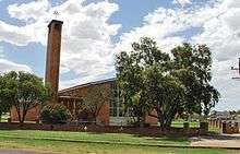
Our Lady of the Southern Cross Catholic Church is on the western corner of George and Elizabeth Streets (28.4136°S 151.0806°E).[22]
Climate
Inglewood has a humid subtropical climate (Köppen Cfa).
| Climate data for Inglewood (Inglewood Forest, 2000–2014) | |||||||||||||
|---|---|---|---|---|---|---|---|---|---|---|---|---|---|
| Month | Jan | Feb | Mar | Apr | May | Jun | Jul | Aug | Sep | Oct | Nov | Dec | Year |
| Record high °C (°F) | 42.0 (107.6) |
40.8 (105.4) |
40.0 (104.0) |
33.9 (93.0) |
31.6 (88.9) |
27.0 (80.6) |
26.3 (79.3) |
35.2 (95.4) |
36.0 (96.8) |
38.0 (100.4) |
41.6 (106.9) |
41.2 (106.2) |
42.0 (107.6) |
| Average high °C (°F) | 33.2 (91.8) |
32.2 (90.0) |
30.4 (86.7) |
27.3 (81.1) |
22.4 (72.3) |
19.0 (66.2) |
18.6 (65.5) |
21.0 (69.8) |
25.3 (77.5) |
28.0 (82.4) |
30.1 (86.2) |
31.5 (88.7) |
26.6 (79.9) |
| Average low °C (°F) | 18.7 (65.7) |
18.0 (64.4) |
16.2 (61.2) |
13.1 (55.6) |
8.8 (47.8) |
6.7 (44.1) |
5.6 (42.1) |
6.9 (44.4) |
10.6 (51.1) |
13.1 (55.6) |
15.9 (60.6) |
17.7 (63.9) |
12.6 (54.7) |
| Record low °C (°F) | 11.9 (53.4) |
10.7 (51.3) |
7.5 (45.5) |
2.8 (37.0) |
−2.0 (28.4) |
−2.0 (28.4) |
−2.7 (27.1) |
−1.9 (28.6) |
−2.0 (28.4) |
3.5 (38.3) |
4.6 (40.3) |
8.6 (47.5) |
−2.7 (27.1) |
| Average rainfall mm (inches) | 72.3 (2.85) |
54.5 (2.15) |
63.5 (2.50) |
27.4 (1.08) |
28.6 (1.13) |
33.3 (1.31) |
28.7 (1.13) |
24.3 (0.96) |
34.0 (1.34) |
49.7 (1.96) |
79.9 (3.15) |
97.3 (3.83) |
587.3 (23.12) |
| Average precipitation days | 7.4 | 7.2 | 6.8 | 4.7 | 4.6 | 7.5 | 5.9 | 5.0 | 5.8 | 7.2 | 8.7 | 8.5 | 79.3 |
| Average relative humidity (%) | 32 | 36 | 35 | 35 | 38 | 46 | 42 | 33 | 30 | 27 | 34 | 34 | 35 |
| Source: Bureau of Meteorology[23] | |||||||||||||
See also
| Wikimedia Commons has media related to Inglewood, Queensland. |
Notes
- Australian Bureau of Statistics (27 June 2017). "Inglewood (SSC)". 2016 Census QuickStats. Retrieved 20 October 2018.

- "Inglewood - town in Goondiwindi Region (entry 16682)". Queensland Place Names. Queensland Government. Retrieved 16 November 2019.
- "Inglewood - locality in Goondiwindi Region (entry 47813)". Queensland Place Names. Queensland Government. Retrieved 16 November 2019.
- "Macintyre Brook Irrigators Association". Archived from the original on 21 February 2011. Retrieved 6 May 2011.
- "Bigambul". State Library of Queensland. Retrieved 15 January 2020.
- Premier Postal History. "Post Office List". Premier Postal Auctions. Retrieved 10 May 2014.
- "Goondiwindi Regional Council - Inglewood History". Retrieved 7 May 2011.
- Queensland Family History Society (2010), Queensland schools past and present (Version 1.01 ed.), Queensland Family History Society, ISBN 978-1-921171-26-0
- "Inglewood - Queensland Places". Retrieved 7 May 2011.
- "Inglewood War Memorial". Monument Australia. Retrieved 5 April 2014.
- "History of St Maria Goretti School". Toowoomba Catholic Education. Archived from the original on 5 July 2017. Retrieved 5 July 2017.
- "Public Libraries Statistical Bulletin 2016-17" (PDF). Public Libraries Connect. November 2017. Retrieved 29 January 2018.
- Australian Bureau of Statistics (31 October 2012). "Inglewood (Qld)". 2011 Census QuickStats. Retrieved 29 September 2015.
- "Goondiwindi Region - Recreation". Retrieved 6 May 2011.
- "Australian Heritage - Inglewood Heritage Centre". Retrieved 6 May 2011.
- "State and non-state school details". Queensland Government. 9 July 2018. Archived from the original on 21 November 2018. Retrieved 21 November 2018.
- "Inglewood State School". Retrieved 21 November 2018.
- "ACARA School Profile 2017". Archived from the original on 22 November 2018. Retrieved 22 November 2018.
- "St Maria Goretti School". Retrieved 21 November 2018.
- "Inglewood". Centre for the Government of Queensland. Retrieved 12 May 2013.
- "Inglewood Library". Public Libraries Connect. 28 July 2015. Retrieved 29 January 2018.
- "Our Lady of the Southern Cross Church, Inglewood". Roman Catholic Diocese of Toowoomba. Retrieved 18 November 2019.
- "Climate Statistics for Inglewood, Queensland". Retrieved 9 September 2015.
External links
| Wikimedia Commons has media related to Inglewood, Queensland. |
- "Inglewood". Queensland Places. Centre for the Government of Queensland, University of Queensland.
- www.inglewood.org.au
- Town map of Inglewood, 1973
- Goondiwindi Regional Council