Dulacca, Queensland
Dulacca is a town and a locality in the Western Downs Region, Queensland, Australia.[2][3]
| Dulacca Queensland | |||||||||||||||
|---|---|---|---|---|---|---|---|---|---|---|---|---|---|---|---|
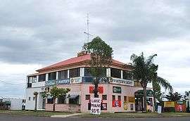 Dulacca Hotel, a typical Queensland pub, but with the verandas walled in | |||||||||||||||
 Dulacca | |||||||||||||||
| Coordinates | 26°39′S 149°45′E | ||||||||||||||
| Population | 249 (2011 census)[1] | ||||||||||||||
| • Density | 0.5053/km2 (1.3087/sq mi) | ||||||||||||||
| Postcode(s) | 4425 | ||||||||||||||
| Area | 492.8 km2 (190.3 sq mi) | ||||||||||||||
| Location | |||||||||||||||
| LGA(s) | Western Downs Region | ||||||||||||||
| State electorate(s) | Warrego | ||||||||||||||
| Federal Division(s) | Maranoa | ||||||||||||||
| |||||||||||||||
Geography
Dulacca is on the Darling Downs, 380 kilometres (240 mi) north west of the state capital, Brisbane. The Warrego Highway traverses from east to west through the locality, passing through the town. The Western railway line also traverses from east to west immediately south and parallel to the highway with the town being served by Dulacca railway station.[4][5]
Dulucca Creek flows through the locality from the town to the south, eventually being a tributary to the Balonne River.[5]
History
The name Dulacca is believed to be derived from the Aboriginal word doolucah meaning emu nest.[2]
Dulacca Post Office opened on 3 March 1879.[6]
Dulacca State School opened on 1 March 1909.[7]
Rainville State School opened on 29 April 1912 but closed in 1917 due to low student numbers. It reopened in 1918 but closed again on 25 February 1921. On 6 April 1925 it reopened as Dulucca South State School but closed in 1930 before reopening again in 1933. It closed permanently on 30 December 1946.[7]
Dulacca North State School opened on 28 January 1919, closing in 1936 due to low student numbers. It reopened in 1941 and closed permanently in 1953.[7]
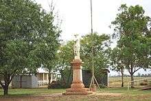
The Dulacca War Memorial was dedicated on 3 December 1921.[8]
St James The Less Anglican church was dedicated on 24 May 1958 by the Right Rev'd David Hand, Assistant of Bishop of the Diocese of New Guinea. Its closure in circa 2015 was approved by Bishop Cameron Venables.[9]
At the 2011 census Dulacca had a population of 249.[1]
Education
Dulacca State School is a government co-educational primary school (P-6) on North Road. In 2016 the school had an enrolment of 24 students with 3 teachers (2 full-time equivalent) and 5 non-teaching staff (2 full-time equivalent).[10]
References
- Australian Bureau of Statistics (31 October 2012). "Dulacca (State Suburb)". 2011 Census QuickStats. Retrieved 27 January 2020.

- "Dulacca - town in Western Downs Region (entry 10769)". Queensland Place Names. Queensland Government. Retrieved 12 September 2017.
- "Dulacca - locality in Western Downs Region (entry 47695)". Queensland Place Names. Queensland Government. Retrieved 12 September 2017.
- "Dulacca - railway station in Western Downs Region (entry 10771)". Queensland Place Names. Queensland Government. Retrieved 16 September 2017.
- "Queensland Globe". State of Queensland. Retrieved 15 September 2017.
- Premier Postal History. "Post Office List". Premier Postal Auctions. Archived from the original on 15 May 2014. Retrieved 10 May 2014.
- Queensland Family History Society (2010), Queensland schools past and present (Version 1.01 ed.), Queensland Family History Society, ISBN 978-1-921171-26-0
- "Dulacca War Memorial". Monument Australia. Archived from the original on 7 April 2014. Retrieved 3 April 2014.
- "Closed Churches". Anglican Church of Southern Queensland. Archived from the original on 3 April 2019. Retrieved 3 April 2019.
- "Annual Report 2016" (PDF). Dulacca State School. Archived from the original (PDF) on 16 September 2017. Retrieved 16 September 2017.