Tummaville, Queensland
Tummaville is a locality in the Toowoomba Region, Queensland, Australia.[1]
| Tummaville Queensland | |||||||||||||||
|---|---|---|---|---|---|---|---|---|---|---|---|---|---|---|---|
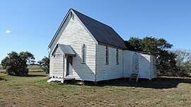 Former St Paul’s Anglican Church, corner of Church Road and Grasstree Road, Tummaville, 2015 | |||||||||||||||
 Tummaville | |||||||||||||||
| Coordinates | 27.9166°S 151.5°E | ||||||||||||||
| Postcode(s) | 4352 | ||||||||||||||
| Area | 317.8 km2 (122.7 sq mi) | ||||||||||||||
| LGA(s) | Toowoomba Region | ||||||||||||||
| State electorate(s) | Southern Downs | ||||||||||||||
| Federal Division(s) | Maranoa | ||||||||||||||
| |||||||||||||||
History
The locality's name is derived from the parish name, allegedly an Aboriginal corruption of the name Domville referring to pastoralist Domville Taylor who was in the area in the 1840s.[1]
St Paul's Church
St Paul's Anglican Church is on the corner of Church Road and Grasstree Road. It was dedicated on 25 February 1891 by Bishop William Thomas Thornhill Webber and was closed circa 1985.[2] The cemetery to the side of the church is now operated by the Toowoomba Regional Council.[3]
References
- "Tummaville - locality in Toowoomba Region (entry 49190)". Queensland Place Names. Queensland Government. Retrieved 31 December 2017.
- "Closed Churches". Anglican Records and Archives Centre. Archived from the original on 3 April 2019. Retrieved 19 June 2019.
- "Cemetery locations". Toowoomba Regional Council. Archived from the original on 15 June 2019. Retrieved 19 June 2019.
Further reading
| Wikimedia Commons has media related to Tummaville, Queensland. |
- Uebergang, Grant (1990). A history of St Paul's Anglican Church, Tummaville [Grasstree] and St Peter's Anglican church, Millmerran [Back Creek], 1891-1991. G.D. Uebergang. ISBN 978-0-646-04306-7.
- Crompton, Arthur (1993). QCWA Tummaville Branch, 1959-1993. A. Crompton.
This article is issued from Wikipedia. The text is licensed under Creative Commons - Attribution - Sharealike. Additional terms may apply for the media files.