Moonie, Queensland
Moonie is a rural town in the Western Downs Region and a locality split between the Western Downs Region and the Goondiwindi Region in Queensland, Australia.[2][3][4] At the 2016 Census, Moonie had a population of 189.[1]
| Moonie Queensland | |||||||||||||||
|---|---|---|---|---|---|---|---|---|---|---|---|---|---|---|---|
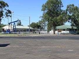 The playground, craft and information centre at Moonie | |||||||||||||||
 Moonie | |||||||||||||||
| Coordinates | 27.6822°S 150.3425°E | ||||||||||||||
| Population | 189 (2016 census)[1] | ||||||||||||||
| • Density | 0.08578/km2 (0.2222/sq mi) | ||||||||||||||
| Postcode(s) | 4406 | ||||||||||||||
| Area | 2,203.2 km2 (850.7 sq mi) | ||||||||||||||
| Location | |||||||||||||||
| LGA(s) | |||||||||||||||
| State electorate(s) | Warrego | ||||||||||||||
| Federal Division(s) | Maranoa | ||||||||||||||
| |||||||||||||||
Geography
The town is on the Darling Downs at the intersection of the Leichhardt and Moonie Highways, 331 kilometres (206 mi) west of the state capital, Brisbane, and is the Official Oil Capital of Australia. The locality is split between the Western Downs Region (northern part of the locality) and the Goondiwindi Region (southern part of the locality).
The Moonie Highway passes through the locality from the north-east to the south-west. The Leichhardt Highway passes through the locality from the north to the south. The town is at the intersection of the two highways.[5]
History
The town's name is derived from Moonie River, which was first recorded as Mooni by Sir Thomas Mitchell in November 1846 when he passed through the region.[6]
Moonie State School opened on 14 May 1962.[7]
Moonie Post Office opened by June 1966 closed in 1983.[8]
Moonie Library opened in 2003.[9]
Economy
In December 1961 Moonie was the site of Australia's first commercial oil field, a very small field consisting of less than one percent of Australia's oil and gas reserves.[10] The oil field is still operational and pumps out 35 kilolitres (7,700 gallons) every day.[11]
The region is also an agricultural area that produces grain, beef cattle and prime lambs.
Education
Moonie State School is a government co-educational primary (P-6) school at 11305 Moonie Highway. In 2016, the school had an enrolment of 43 students with 4 teachers (3 full-time equivalent) and 5 non-teaching staff (2 full-time equivalent).[12]
Amenities
The town has a service station, the Moonie Sports Club and a motel.
Moonie Library is located on the Leichhardt Highway.[13]
References
- Australian Bureau of Statistics (27 June 2017). "Moonie (State Suburb)". 2016 Census QuickStats. Retrieved 17 January 2020.

- "Moonie - town in Western Downs Region (entry 22670)". Queensland Place Names. Queensland Government. Retrieved 29 December 2017.
- "Moonie - locality in Western Downs Region (entry 47730)". Queensland Place Names. Queensland Government. Retrieved 29 December 2017.
- "Moonie - locality in Goondiwindi Region (entry 47820)". Queensland Place Names. Queensland Government. Retrieved 29 December 2017.
- "Queensland Globe". State of Queensland. Retrieved 19 September 2017.
- "MOONIE, QUEENSLAND". Retrieved 30 May 2011.
- Queensland Family History Society (2010), Queensland schools past and present (Version 1.01 ed.), Queensland Family History Society, ISBN 978-1-921171-26-0
- Premier Postal History. "Post Office List". Premier Postal Auctions. Retrieved 10 May 2014.
- "Public Libraries Statistical Bulletin 2016-17" (PDF). Public Libraries Connect. State Library of Queensland. November 2017. p. 16. Archived (PDF) from the original on 30 January 2018. Retrieved 30 January 2018.
- "Moonie". Walkabout - Australian Travel Guide. Fairfax. Archived from the original on 3 September 2007. Retrieved 23 September 2007.
- "Places to Visit - Western Downs - Moonie". Queensland Holidays. Tourism Queensland. Retrieved 23 September 2007.
- "Annual Report 2016" (PDF). Moonie State School. Archived (PDF) from the original on 19 September 2017. Retrieved 19 September 2017.
- "Public Libraries Statistical Bulletin 2016-17". Public Libraries Connect. State Library of Queensland. p. 16. Retrieved 19 January 2018.