New England Highway
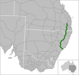
The New England Highway is an 878-kilometre (546 mi) long[1] highway in Australia running from Hexham at Newcastle, New South Wales at its southern end to Yarraman, north of Toowoomba, Queensland at its northern end. It is part of Australia's National Highway system, and forms part of the inland route between Brisbane and Sydney.[2]
New England Highway –New South Wales | |
|---|---|
 | |
| General information | |
| Type | Highway |
| Length | 878 km (546 mi)[1] |
| Route number(s) |
|
| Former route number | |
| Major junctions | |
| North end | |
| |
| South end |
|
| Location(s) | |
| Major settlements | Crows Nest, Toowoomba, Warwick, Tenterfield, Glen Innes, Armidale, Tamworth, Muswellbrook, Maitland |
| Highway system | |
Route description
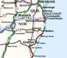
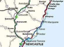
At its southern end the New England Highway connects to the Pacific Highway and at its northern end it connects to the D'Aguilar Highway. It traverses the Hunter Valley, New England, and the Southern and Darling Downs regions.
During the winter months, some parts of the New England Highway are subject to frost and snowfall[3][4], with the 350 km section from the Moonbi Ranges to Stanthorpe located at high altitudes.
Traffic volume
In 2013-14, the New England Highway and Cunningham Highway combined (known as the Sydney-Brisbane inland route) had an average annual daily traffic count of just over 13,000 vehicles, which is approximately half that seen on the coastal route (i.e., the Pacific Highway and Pacific Motorway).[2] Heavy vehicles account for approximately 13% of the traffic seen on the route.[2]
Speed cameras
As of November 2018, fixed speed cameras were located at Ben Lomond (between Ross Road and Ben Lomond Road), Blandford (between Hayles Street and Mills Street) and Tenterfield (between Duncan Street and George Street).[5] Average speed enforcement (point-to-point) cameras target heavy vehicles between Singleton and Muswellbrook.[6][7]
History
The New England Highway has its origins in the track which developed north from Newcastle to reach the prime wool growing areas of the New England region which Europeans settled following expeditions by NSW Surveyor-General John Oxley in 1818 and botanist Allan Cunningham in 1827 and 1829. The rough track, navigable only by horse or bullock dray, crossed the Liverpool Range, went through Tamworth and ended at Tenterfield.[8] The track became known as the Great Northern Road.[9] During the 1860s, several robberies occurred along the road[10][11], with infamous bushranger Captain Thunderbolt known to be active in the area.[12]
When the NSW main road system was reorganised in August 1928, the Great Northern Road was gazetted as part of state highway 9 and renamed the Great Northern Highway.[13] At proclamation, the Great Northern Highway was described as stretching from North Sydney to the Queensland border at Mount Lindesay, via Newcastle, Maitland, Tamworth, Armidale, Tenterfield and Woodenbong.[13] The route became known as the New England Highway in early-1933 by combining the Great Northern Highway and the Brisbane-Mount Lindesay-Warwick Highway into a single uniformly-named road from Hexham to Brisbane.[14][15] In 1936 the road was described by contemporary observers as being in good condition, with spectacular scenery and excellent accommodation en route.[16][17]
In 1954 the New England Highway was re-routed through Warwick along the route that was then known as the Lockyer-Darling Downs Highway.[18] Against the wishes of the Beaudesert Shire Council and the Woodenbong Chamber of Commerce[19], the former New England Highway through Beaudesert was renamed the Mount Lindesay Highway.[20]
In the 1970s, the Queensland Main Roads Department rerouted the designation of the New England Highway north of Warwick to follow the former Lockyer-Darling Downs Highway (national route 17) so that it terminated in Toowoomba. The section of the highway between Brisbane and Warwick was renamed as part of the Cunningham Highway, which until that time had extended only westward from Warwick to Goondiwindi.


Highway improvements
As of October 2018, completed, current or proposed improvements on the New England Highway include[21]:
- Belford to the Golden Highway
- Maitland roundabout improvements
- Muswellbrook bypass
- New England Highway draft corridor strategy
- New England Highway and Wyndella Road intersection, Lochinvar
- Scone bypass
- Singleton rail underpass
- Singleton bypass
- Fitzgerald Bridge at Aberdeen
- Tenterfield heavy vehicle bypass
- Bolivia Hill
Former allocations
Major junctions
| State | LGA / LGA | Location | km[1] | mi | Destinations | Notes |
|---|---|---|---|---|---|---|
| Queensland | Toowoomba | Yarraman | 0 | 0.0 | T intersection northern terminus; north (A3) and southeast (A17) as the D'Aguilar Highway | |
| Wutul | 33 | 21 | T intersection; New England Highway continues southeast | |||
| Crows Nest Creek | 74 | 46 | Bridge over the river (no known name) | |||
| Toowoomba | Hampton | 86 | 53 | Four-way intersection; northern concurrency terminus as | ||
| Toowoomba | 118 | 73 | Four-way intersection; eastern concurrency terminus as | |||
| 119 | 74 | Four-way intersection; western concurrency terminus as | ||||
| Four-way intersection; southern concurrency terminus as | ||||||
| Cambooya | 133 | 83 | Drayton Connection Road – Drayton, Toowoomba | Y intersection; New England Highway continues south | ||
| 137 | 85 | T intersection; New England Highway continues south | ||||
| Clifton | 162 | 101 | T intersection; New England Highway continues south | |||
| Southern Downs | Glengallan | 188 | 117 | Directional T interchange; southern terminus as | ||
| Condamine River | 199 | 124 | O.O. Madsen Bridge | |||
| Southern Downs | Warwick | 202 | 126 | 4-way intersection; southern terminus as | ||
| Stanthorpe | 137 | 85 | Wallangarra Road – Stanthorpe to | Directional T interchange; New England Highway continues south | ||
| Queensland – New South Wales state border | 299 | 186 | Queensland – New South Wales state border | |||
| New South Wales | Tenterfield | Tenterfield | 313 | 194 | Bruxner Highway (no shield) – Boggabilla | Uncontrolled 4-way intersection; northern concurrency terminus; New England Highway continues south |
| 318 | 198 | Uncontrolled 4-way intersection; southern concurrency terminus; New England Highway continues south | ||||
| Deepwater River | 370 | 230 | Bridge over the river (no known name) | |||
| Glen Innes Severn | Glen Innes | 409 | 254 | Uncontrolled 4-way intersection; northern concurrency terminus; New England Highway continues south | ||
| Uncontrolled 4-way intersection; southern concurrency terminus; New England Highway continues south | ||||||
| Armidale | Armidale | 511 | 318 | Roundabout; New England Highway continues south | ||
| Bendemeer | 576 | 358 | T intersection; northern concurrency terminus as | |||
| Tamworth | Tamworth | 616 | 383 | Roundabout; southern concurrency terminus as | ||
| Peel River | 613 | 381 | Bridge over the river (no known name) | |||
| Liverpool Plains | Willow Tree | 684 | 425 | Directional T interchange; New England Highway continues south | ||
| Pages River | 703 | 437 | Bridge over the river (no known name) | |||
| Pages River | 707 | 439 | Bridge over the river (no known name) | |||
| Pages River | 710 | 440 | Bridge over the river (no known name) | |||
| Hunter River | 755 | 469 | Fitzgerald[22] Bridge | |||
| Muswellbrook | Muswellbrook | 769 | 478 | Denman Road – Denman | T intersection; New England Highway continues southeast | |
| Hunter River | 815 | 506 | Bridge over the river (no known name) | |||
| Singleton | Whittingham | 827 | 514 | T intersection; New England Highway continues southeast | ||
| Belford | 835 | 519 | T intersection; | |||
| Branxton | 838 | 521 | T intersection; New England Highway (no shield) continues east | |||
| 840 | 520 | Y intersection; New England Highway transitions to | ||||
| Maitland | Maitland | 862 | 536 | Cessnock Road – Kurri Kurri, Cessnock | Roundabout; New England Highway continues southeast | |
| Newcastle | Tarro | 875 | 544 | Directional T interchange; incomplete northwest concurrency terminus as | ||
| Hexham | 879 | 546 | Directional T interchange; southeast concurrency terminus as | |||
1.000 mi = 1.609 km; 1.000 km = 0.621 mi
| ||||||
Cities and towns
From its junction with the Pacific Highway at Hexham, 12 km (7 mi) inland from Newcastle the New England Highway connects the following cities and towns:
New South Wales
Queensland
- Wallangarra
- Stanthorpe
- Warwick
- Toowoomba
See also
- Highways in Australia
- List of highways in New South Wales
- List of highways in Queensland
- Moonbi Range
- Hunter Expressway
- List of highways numbered 85
References
- "1 New England Highway, Yarraman QLD 4614 to 187 Maitland Road, Hexham NSW 2322". Google Maps. Google Inc. 2016. Retrieved 28 October 2016.
- Bureau of Infrastructure, Transport and Regional Economics (BITRE) (2016). Traffic on the national road network, 2013–14, Information Sheet 80 (PDF). Canberra: Commonwealth of Australia. Archived from the original (PDF) on 29 March 2019. Retrieved 24 January 2019.
- "More Snow Pics: Because you can never have enough". The Armidale Express. 17 July 2015.
- "Snow turns to ice closing highway". Guyra Argus. 9 August 2012.
- "Current locations - New fixed digital speed camera location - November 2018". Transport for New South Wales. NSW Government. Archived from the original on 31 January 2019. Retrieved 31 January 2019.
- "Average speed enforcement camera locations". Transport for New South Wales. NSW Government. Archived from the original on 31 January 2019. Retrieved 31 January 2019.
- "Average Speed Enforcement for Heavy Vehicles: Factsheet" (PDF). Transport for New South Wales. NSW Government. Archived (PDF) from the original on 31 January 2019. Retrieved 31 January 2019.
- Tenterfield District Historical Society (1949). Tenterfield. National Library of Australia. p. 31.
- "New England Highway : History and Development". Ozroads. Archived from the original on 4 March 2017. Retrieved 28 October 2016.
- "Daring mail robbery on the Great Northern Road". Newcastle Chronicle and Hunter River District News. National Library of Australia. 30 October 1861. p. 2. Retrieved 21 January 2019.
- "Highway robberies on the Great Northern Road". Maitland Mercury and Hunter River General Advertiser. National Library of Australia. 22 December 1863. p. 3. Retrieved 21 January 2019.
- "Memories of Thunderbolt". Coffs Harbour Advocate. National Library of Australia. 10 May 1940. p. 2. Retrieved 21 January 2019.
- "Main Roads Act, 1924-1927". Government Gazette of the State of New South Wales (110). National Library of Australia. 17 August 1928. pp. 3814–3815. Retrieved 21 January 2019.
- "New England Highway". Kyogle Examiner. National Library of Australia. 14 February 1933. p. 2. Retrieved 21 January 2019.
- "New England Highway". Uralla Times. National Library of Australia. 23 February 1933. p. 11. Retrieved 21 January 2019.
- "Motoring along the New England Highway, part 1". Sydney Mail. National Library of Australia. 2 September 1936. Retrieved 24 January 2019.
- "Motoring along the New England Highway, part 2". Sydney Mail. National Library of Australia. 9 September 1936. Retrieved 24 January 2019.
- ""New England" Highway now via Warwick". Warwick Daily News. National Library of Australia. 9 November 1954. Retrieved 24 January 2019.
- "New England Highway: Council against change of name". Beaudesert Times. National Library of Australia. 21 May 1954. Retrieved 24 January 2019.
- ""New England" Highway now via Warwick". Warwick Daily News. National Library of Australia. 9 November 1954. Retrieved 24 January 2019.
- "New England Highway". Roads and Maritime Services. NSW Government. Archived from the original on 31 January 2019. Retrieved 31 January 2019.
- "Opening the bridge". Trove. 27 July 1893. Archived from the original on 21 January 2018. Retrieved 21 January 2018.
External links
| Wikimedia Commons has media related to New England Highway. |
| Wikivoyage has a travel guide for New England Highway. |
| ||