The Gums, Queensland
The Gums is a rural town and locality in the Western Downs Region, Queensland, Australia.[2][3] In the 2016 census, The Gums had a population of 159 people.[1]
| The Gums Queensland | |||||||||||||||
|---|---|---|---|---|---|---|---|---|---|---|---|---|---|---|---|
 The Gums | |||||||||||||||
| Coordinates | 27.3402°S 150.205°E | ||||||||||||||
| Population | 159 (2016 census)[1] | ||||||||||||||
| • Density | 0.1466/km2 (0.3798/sq mi) | ||||||||||||||
| Postcode(s) | 4406 | ||||||||||||||
| Area | 1,084.4 km2 (418.7 sq mi) | ||||||||||||||
| Time zone | AEST (UTC+10:00) | ||||||||||||||
| Location | |||||||||||||||
| LGA(s) | Western Downs Region | ||||||||||||||
| State electorate(s) | Warrego | ||||||||||||||
| Federal Division(s) | Maranoa | ||||||||||||||
| |||||||||||||||
Geography
The town is at the junction of the Leichhardt Highway and the Surat Developmental Road[4] on the Darling Downs, 329 kilometres (204 mi) west of the state capital, Brisbane.
The Glenmorgan railway line passes through the locality from east (Tara) to west (Hannaford). In 2017, there were three stations serving the locality: The Gums railway station (which is north of but close to the town, 27.3286°S 150.1853°E),[5] Cabawin railway station (27.3294°S 150.2503°E),[6] and South Glen railway station (27.3053°S 150.3167°E).[7] However, in 2019, only The Gums railway station is listed as still operational.[8]
History
The name of the town was derived from The Gums railway station, on the Glenmorgan railway line from Dalby to Glenmorgan,[9] used from 1924.[2][3]
South Glen Provisional School opened in 1913 and closed circa 1921.[10]
The Gums State School opened on 27 January 1913.[10]
Cabawin Provisional School opened on 30 January 1934. In 1952 it became Cabawin State School. It closed in 1960.[10] It was on Cabawin South Road (27.3644°S 150.2582°E).[11]
At the 2006 census, The Gums and the surrounding area had a population of 169.[12]
In the 2016 census, The Gums had a population of 159 people.[1]
Education

The Gums State School is a government primary (Prep-6) school for boys and girls at 12051 Coomrith Road (27.3414°S 150.1994°E).[13][14] In 2017, the school had an enrolment of 22 students with 4 teachers (2 full-time equivalent) and 5 non-teaching staff (2 full-time equivalent).[15]
There is no secondary school in The Gums. The nearest secondary school is Tara Shire State College in Tara.[16]
Facilities
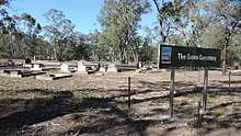
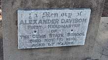
The Gums has a small cemetery (27.3393°S 150.1960°E). One of the headstones is for the first headmaster of The Gums State School, Alexander Davison who died on 7 November 1916.
References
- Australian Bureau of Statistics (27 June 2017). "The Gums (SSC)". 2016 Census QuickStats. Retrieved 20 October 2018.

- "The Gums - town in Western Downs Region (entry 33961)". Queensland Place Names. Queensland Government. Retrieved 27 January 2020.
- "The Gums - locality in Western Downs Region (entry 47751)". Queensland Place Names. Queensland Government. Retrieved 27 January 2020.
- "The Gums". australianexplorer.com. Archived from the original on 6 March 2012. Retrieved 15 October 2010.
- "The Gums - railway station in the Western Down Region (entry 33962)". Queensland Place Names. Queensland Government. Retrieved 25 December 2017.
- "Cabawin - railway station in the Western Downs Region (entry 5606)". Queensland Place Names. Queensland Government. Retrieved 26 December 2017.
- "South Glen - railway station in the Western Downs Region (entry 31458)". Queensland Place Names. Queensland Government. Retrieved 25 December 2017.
- "Queensland Globe". State of Queensland. Retrieved 6 June 2019.
- "Location Profiles - Darling Downs-West Moreton Health Service District - GLENMORGAN". Queensland Government. 23 February 2010. Archived from the original on 20 March 2011. Retrieved 17 October 2010.
- Queensland Family History Society (2010), Queensland schools past and present (Version 1.01 ed.), Queensland Family History Society, ISBN 978-1-921171-26-0
- "Queensland Two Mile series sheet 2m48" (Map). Queensland Government. 1955. Archived from the original on 24 April 2020. Retrieved 25 April 2020.
- Australian Bureau of Statistics (25 October 2007). "The Gums (Tara Shire) (State Suburb)". 2006 Census QuickStats. Retrieved 4 November 2008.
- "State and non-state school details". Queensland Government. 9 July 2018. Archived from the original on 21 November 2018. Retrieved 21 November 2018.
- "The Gums State School". Archived from the original on 1 April 2020. Retrieved 21 November 2018.
- "ACARA School Profile 2017". Archived from the original on 22 November 2018. Retrieved 22 November 2018.
- "Queensland Globe". State of Queensland. Retrieved 24 April 2020.
External links
| Wikimedia Commons has media related to The Gums, Queensland. |