Mount Lofty, Queensland
Mount Lofty is a locality on the edge of the suburban area of Toowoomba, Toowoomba Region, Queensland, Australia, located 3 kilometres (2 mi) north-east of the city centre.[2]
| Mount Lofty Toowoomba, Queensland | |||||||||||||||
|---|---|---|---|---|---|---|---|---|---|---|---|---|---|---|---|
 Mount Lofty | |||||||||||||||
| Coordinates | 27.537°S 151.984°E | ||||||||||||||
| Population | 3,775 (2016 census)[1] | ||||||||||||||
| • Density | 572/km2 (1,481/sq mi) | ||||||||||||||
| Postcode(s) | 4350 | ||||||||||||||
| Area | 6.6 km2 (2.5 sq mi) | ||||||||||||||
| Location | 3 km (2 mi) NE of Toowoomba | ||||||||||||||
| LGA(s) | Toowoomba Region | ||||||||||||||
| State electorate(s) | Toowoomba North | ||||||||||||||
| Federal Division(s) | Groom | ||||||||||||||
| |||||||||||||||
Geography
Jubilee Park, a large parkland and bushland area with numerous riding trails, forms the eastern part of the suburb. At the end of North Street is the peak of Mount Lofty, which features a garden and rainforest, a lookout, and the transmission tower for WIN Television. Nearby is Toowoomba State High School (Mount Lofty Campus) and a rifle range used by Toowoomba Rifle Club, that is no longer in use.[3]
Heritage listings
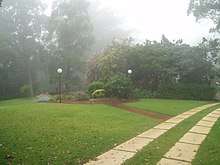
Boyce gardens - entrance and driveway.
Mount Lofty has a number of heritage-listed sites:
- 6 Range Street: Boyce Gardens[4]
References
- Australian Bureau of Statistics (27 June 2017). "Mount Lofty (State Suburb)". 2016 Census QuickStats. Retrieved 15 April 2018.

- "Mount Lofty - locality (entry 48012)". Queensland Place Names. Queensland Government. Retrieved 29 November 2016.
- Brisway Publishing (2008). Brisway: Greater Brisbane, Sunshine Coast, Gold Coast and Toowoomba. p. Map T221. ISBN 978-0-909439-30-9.
- "Boyce Gardens (entry 601311)". Queensland Heritage Register. Queensland Heritage Council. Retrieved 15 July 2013.
This article is issued from Wikipedia. The text is licensed under Creative Commons - Attribution - Sharealike. Additional terms may apply for the media files.