Twentynine Palms, California
Twentynine Palms (also known as 29 Palms) is a city in San Bernardino County, California. It was previously called Twenty-Nine Palms.
City of Twentynine Palms | |
|---|---|
City | |
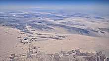
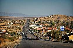 Twentynine Palms looking east on Highway 62 | |
 Seal | |
| Motto(s): "A Beautiful Desert Oasis" | |
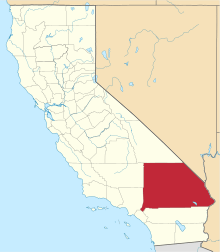
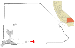 Location in San Bernardino County and the state of California | |
 City of Twentynine Palms Location in the United States | |
| Coordinates: 34°08′08″N 116°03′15″W[1] | |
| Country | |
| State | |
| County | |
| Incorporated | November 23, 1987[2] |
| Government | |
| • Type | Council–manager[3] |
| Area | |
| • Total | 59.14 sq mi (153.18 km2) |
| • Land | 59.14 sq mi (153.18 km2) |
| • Water | 0.00 sq mi (0.00 km2) 0% |
| Elevation | 1,988 ft (606 m) |
| Population (2010) | |
| • Total | 25,048 |
| • Estimate (2019)[5] | 26,073 |
| • Density | 440.87/sq mi (170.21/km2) |
| Time zone | UTC-8 (Pacific) |
| • Summer (DST) | UTC-7 (PDT) |
| ZIP codes | 92277-92278 |
| Area codes | 442/760 |
| FIPS code | 06-80994 |
| GNIS feature IDs | 1652804, 2412119 |
| Website | www |
History
Twentynine Palms was named for the palm trees found there in 1852 by Col. Henry Washington while surveying the San Bernardino base line.[6] A post office was established in 1927.[7]
A road named Utah Trail honors the late 1800s pioneers on a trail originating in Utah (reportedly Saint George) that went to Twentynine Palms.
Nearby is a small Indian reservation belonging to the Twenty-Nine Palms Band of Mission Indians.
Joshua Tree National Park, which lies just to the south of Twentynine Palms, was designated a national monument in 1936, and became a national park in 1994. The nearby Marine Corps Air Ground Combat Center Twentynine Palms was founded in 1952.
Demographics
| Historical population | |||
|---|---|---|---|
| Census | Pop. | %± | |
| 1970 | 5,667 | — | |
| 1980 | 7,465 | 31.7% | |
| 1990 | 11,821 | 58.4% | |
| 2000 | 14,764 | 24.9% | |
| 2010 | 25,048 | 69.7% | |
| Est. 2019 | 26,073 | [5] | 4.1% |
| U.S. Decennial Census[8] | |||
Its population as of July 1, 2013 was estimated at 25,768.[9]
2010 census
At the 2010 census,[10] there were 25,048 people in 8,095 households, including 5,847 families, in the city. The population density was 423.5 people per square mile (163.5/km²). There were 9,431 housing units at an average density of 159.5 per square mile, of the occupied units 2,742 (33.9%) were owner-occupied and 5,353 (66.1%) were rented.The homeowner vacancy rate was 3.6%; the rental vacancy rate was 9.2%. 6,876 people (27.5% of the population) lived in owner-occupied housing units and 14,825 people (59.2%) lived in rental housing units. The racial makeup of the city was 71.6%, White (60.8% non-Hispanic),[9] 8.2% African American, 1.3% Native American, 3.9% Asian, 1.4% Pacific Islander, 6.7% from other races, and 6.9% from two or more races. Hispanic or Latino of any race were 20.8% of the population.
The census reported that 21,701 people (86.6% of the population) lived in households, and 3,347 (13.4%) lived in non-institutionalized group quarters.
Of the 8,095 households 43.3% had children under the age of 18 living in them, 54.5% were opposite-sex married couples living together, 12.9% had a female householder with no husband present, 4.9% had a male householder with no wife present. There were 5.0% unmarried opposite-sex partnerships, and 1.6% same-sex married couples or partnerships. 21.1% of households were one person and 5.6% were one person aged 65 or older. The average household size was 2.68 and the average family size was 3.10.
The age distribution was 25.6% under the age of 18, 30.0% aged 18 to 24, 25.5% aged 25 to 44, 13.1% aged 45 to 64, and 5.8% who were 65 or older. The median age was 23.5 years. For every 100 females, there were 129.0 males. For every 100 females age 18 and over, there were 139.9 males.
The median household income was $42,572. About 14.4% of the population were living below the poverty line.[9]
29 Palms has a good deal of racial diversity. The Hispanic population has increased 50% since the 2000 census. Also African-Americans, Filipinos, Samoans, and Native Americans form sizable percentages. And religiously, sizable communities of Mormons and Seventh-day Adventists.
2000 census
At the 2000 census there were 14,764 people in 5,653 households, including 3,855 families, in the city. The population density was 269.3 inhabitants per square mile (104.0/km²). There were 6,952 housing units at an average density of 126.8 per square mile (49.0/km²). The racial makeup of the city was 71.0% White, 9.4% African American, 1.5% Native American, 3.8% Asian, 10.2% Pacific Islander, 6.2% from other races, and 6.4% from two or more races. Hispanic or Latino of any race were 14.9%.[11]
Of the 5,653 households 39.1% had children under the age of 18 living with them, 49.8% were married couples living together, 13.7% had a female householder with no husband present, and 31.8% were non-families. 25.1% of households were one person and 7.4% were one person aged 65 or older. The average household size was 2.6 and the average family size was 3.1.
The age distribution was 31.2% under the age of 18, 15.2% from 18 to 24, 28.4% from 25 to 44, 16.7% from 45 to 64, and 8.6% 65 or older. The median age was 27 years. For every 100 females, there were 101.8 males. For every 100 females age 18 and over, there were 98.7 males.
The median household income was $31,178 and the median family income was $32,251. Males had a median income of $25,081 versus $25,141 for females. The per capita income for the city was $14,613. About 13.6% of families and 16.8% of the population were below the poverty line, including 25.3% of those under age 18 and 10.0% of those age 65 or over.
Geography
The city is located in the Mojave Desert in Southern California. It lies on the northern side of the Joshua Tree National Park and includes one of the entrances to the park, at the Oasis of Mara.
According to the United States Census Bureau, the city has a total area of 59.1 square miles (153 km2), all land.[12] The city is at an elevation of 1,988 feet (606 m).[1] The Marine Corps Air Ground Combat Center Twentynine Palms is located there.
Climate
Due in large part to its elevation of more than 1,900 ft (580 m) above sea level, Twentynine Palms has a slightly cooler climate, especially during winter, than Palm Springs, but with essentially the same subtropical desert characteristics. On average, temperatures reach 100 °F (38 °C) on 90 days, 90 °F (32 °C) on 155 days, and the freezing mark on 24 nights annually. Extremes range from 10 °F (−12 °C) on December 23, 1990, to 118 °F (48 °C) on July 11, 1961. Winters are moderately cool, with highs in the 60s and the lows in the 40s. Summers are hot, with temperatures above 100. The rainiest month is August with .80 inches of rain, mostly from Monsoon thunderstorms.
| Climate data for Twentynine Palms, California (1981–2010 normals) | |||||||||||||
|---|---|---|---|---|---|---|---|---|---|---|---|---|---|
| Month | Jan | Feb | Mar | Apr | May | Jun | Jul | Aug | Sep | Oct | Nov | Dec | Year |
| Record high °F (°C) | 85 (29) |
90 (32) |
95 (35) |
102 (39) |
112 (44) |
117 (47) |
118 (48) |
116 (47) |
114 (46) |
106 (41) |
93 (34) |
92 (33) |
118 (48) |
| Average high °F (°C) | 61.5 (16.4) |
65.3 (18.5) |
72.3 (22.4) |
79.8 (26.6) |
89.3 (31.8) |
98.0 (36.7) |
102.7 (39.3) |
101.0 (38.3) |
94.7 (34.8) |
82.8 (28.2) |
69.4 (20.8) |
60.1 (15.6) |
81.4 (27.4) |
| Daily mean °F (°C) | 51.1 (10.6) |
54.4 (12.4) |
60.3 (15.7) |
66.8 (19.3) |
75.9 (24.4) |
83.9 (28.8) |
89.4 (31.9) |
88.1 (31.2) |
81.4 (27.4) |
69.8 (21.0) |
57.8 (14.3) |
49.9 (9.9) |
69.1 (20.6) |
| Average low °F (°C) | 40.8 (4.9) |
43.4 (6.3) |
48.2 (9.0) |
53.8 (12.1) |
62.5 (16.9) |
69.7 (20.9) |
76.2 (24.6) |
75.2 (24.0) |
68.0 (20.0) |
56.8 (13.8) |
46.3 (7.9) |
39.7 (4.3) |
56.7 (13.7) |
| Record low °F (°C) | 11 (−12) |
18 (−8) |
23 (−5) |
29 (−2) |
33 (1) |
43 (6) |
53 (12) |
52 (11) |
38 (3) |
24 (−4) |
14 (−10) |
10 (−12) |
10 (−12) |
| Average precipitation inches (mm) | 0.52 (13) |
0.57 (14) |
0.45 (11) |
0.13 (3.3) |
0.09 (2.3) |
0.01 (0.25) |
0.54 (14) |
0.80 (20) |
0.39 (9.9) |
0.18 (4.6) |
0.24 (6.1) |
0.57 (14) |
4.49 (112.45) |
| Average precipitation days (≥ 0.01 in) | 3.2 | 3.2 | 2.5 | 1.2 | 0.8 | 0.2 | 1.6 | 2.6 | 1.6 | 1.1 | 1.2 | 2.4 | 21.6 |
| Source: NOAA (extremes 1935–present)[13] | |||||||||||||
Government
The city uses a council-manager form of government. An elected city council establishes policy and appoints a city manager who executes these policies.[3]
State and federal representation
In the California State Legislature, Twentynine Palms is in the 16th Senate District, represented by Republican Shannon Grove, and in the 42nd Assembly District, represented by ? Chad Mayes.[14]
In the United States House of Representatives, Twentynine Palms is in California's 8th congressional district, represented by Republican Paul Cook.[15]
Economy
The Oasis of Mara,[16] maintained by the United States National Park Service, is visited by approximately 140,000 people every year; per Indian legend, the oasis is the location of the original 29 palm trees planted by the Serrano people.[17]
Education
- Copper Mountain College is a community college serving the Morongo Basin.[18]
- The Morongo Unified School District provides an education for public school students.[19]
- Mayfield College[20] offers a training program to prepare active duty service members for careers in the Heating, Ventilation, Air Conditioning, and Refrigeration (HVAC/R) industry.
Media
- The Desert Trail newspaper in Yucca Valley is published weekly.[21] The Sun Runner Magazine of California Desert Life and Culture is published bi-monthly.[22]
There are two TV stations: K15FC (KESQ-TV (ABC), KPSP (CBS), KDFX (Fox), KCWQ-LD (CW) and KUNA-LP (Telemundo) subchannels) and KPSE-LD (My Network) 29 (also KMIR-TV (NBC), ION, MeTV and Movies! subchannels) from the Riverside County, California TV market, but the area is actually part of the Los Angeles Metropolitan area TV market.
KEXV and KPLM are low power TV stations for the town and Yucca Valley.
KVMD is licensed in Twentynine Palms and serves all of Los Angeles and the Inland Empire.
There is one AM station: KNWH a transmitter of KNWQ-1140 "KNews" Radio – Twentynine Palms (Inland Empire, California and Coachella Valley radio markets) CA US news/talk, and seven commercial plus two public FM Stations –
Low Power FM Translators:
- K214CR|r.KCRW-89.9 NPR – Twentynine Palms (San Bernardino) CA US Public Radio.[23]
- 92.1 KHCS (91.7 Palm Desert) Christian Radio.
- 92.7 KKUU (Indio) Urban/Top 40.
- 95.5 KCLZ (KCLB Coachella) Rock music.
- 96.3 KKCM (KXCM - Palm Springs) Country music.
- 103.3 KDHI (KRCK Mecca) Hot AC.
- 103.7 (KNWZ-FM 94.3 Desert Hot Springs) News radio.
- 106.3 KPLM (Thousand Palms) Country music.
Local stations:
- 101.5 KHWY (Amboy) Classic rock. (High Desert (California) radio market).
- 102.7 KMRB-FM (Joshua Tree) Variety.
- 107.7 KCDZ (Yucca Valley) Local radio.
Transportation

Notable people
- Willie Boy, subject of the novel Willie Boy; A Dessert Manhunt, and the film Tell Them Willie Boy Is Here. He was a Piute-Chemehuevi Indian born in 29 Palms.[24]
- Doug Cockle, actor and director.
- Mike Evans, actor and writer, was a longtime resident and died at his mother's house in Twentynine Palms.[25]
- Cliff Raven, noted American tattoo pioneer, lived and worked in Twentynine Palms in his later years.
- Dick Dale, Legendary "King Of The Surf Guitar", lived on a ranch in 29 Palms before he died in March 2019.
- Elizabeth Warder Crozer Campbell, logged thousands of archeological finds in the 1920s in Joshua Tree Park. Wrote The Desert Was Home.
In popular culture
Music
- A song, "The Lady from 29 Palms", was written by Allie Wrubel in 1947 and recorded by such artists as Frank Sinatra, Freddy Martin, Tony Pastor, and The Andrews Sisters.
- The rock group U2 stayed at Harmony Hotel in the 1980s when working on their famous The Joshua Tree album.
- The album Lily on the Beach by German electronic music ensemble Tangerine Dream contains an instrumental piano ballad called "Twenty-Nine Palms".
- Former Led Zeppelin singer Robert Plant had a hit single called "29 Palms", from his solo album Fate of Nations in 1993.
- The band Sublime mentioned the city of Twentynine Palms, CA in their song "Thanx" off of their 40 oz. to Freedom album. Twentynine Palms is also a city listed in "April 29, 1992 (Miami)" off their self-titled album Sublime.[26]
- Track two of the album Places by Brad Mehldau, released in 2000, is named after the city.[27]
- In 2006, the pop punk band Forever Came Calling was founded here.
- Nashville country band Granville Automatic has a song named after the town, inspired by the book by Deanne Stillman
Film
- Some scenes in the 1963 comedy film It's a Mad, Mad, Mad, Mad World were shot in Twentynine Palms.[28]
- Some scenes in the 1964 comedy film Kiss Me, Stupid were shot in Twentynine Palms.[29]
- Twentynine Palms is a 2003 drama/horror film set in Twentynine Palms.[30]
Radio
On April 22, 1945, The Jack Benny Program was broadcast from Twentynine Palms Auxiliary Naval Air Station. There were jokes about the base's dry, hot weather, along with a comedic sketch of the town's history.[31]
References
- "Twentynine Palms". Geographic Names Information System. United States Geological Survey. Retrieved October 12, 2014.
- "California Cities by Incorporation Date". California Association of Local Agency Formation Commissions. Archived from the original (Word) on November 3, 2014. Retrieved August 25, 2014.
- "Council/Manager Form of Government". City of Twentynine Palms. Archived from the original on December 29, 2014. Retrieved January 24, 2015.
- "2016 U.S. Gazetteer Files". United States Census Bureau. Retrieved June 28, 2017.
- "Population and Housing Unit Estimates". Retrieved May 21, 2020.
- Gudde, Erwin Gustav; Bright, William (1998). California Place Names: The Origin and Etymology of Current Geographical Names (4th ed.). Berkeley, CA: University of California Press. p. 277. ISBN 978-0-520-24217-3. LCCN 97043168.
Washington ... found 29 'cabbage trees' ... the common name for the Washington palm.
- Durham, David L. (2001). Place-Names of California's Desert Cities. Clovis, CA: Quill Driver Books. p. 178. ISBN 978-1-884995-31-6.
- "Census of Population and Housing". Census.gov. Retrieved June 4, 2015.
- "Twentynine Palms (city) QuickFacts". United States Census Bureau. Archived from the original on January 10, 2015. Retrieved January 9, 2015.
- "2010 Census Interactive Population Search: CA - Twentynine Palms city". U.S. Census Bureau. Archived from the original on July 15, 2014. Retrieved July 12, 2014.
- "U.S. Census website". United States Census Bureau. Retrieved January 31, 2008.
- "2010 Census U.S. Gazetteer Files – Places – California". United States Census Bureau.
- "NowData – NOAA Online Weather Data". National Oceanic and Atmospheric Administration. Retrieved July 3, 2013.
- "Statewide Database". UC Regents. Archived from the original on February 1, 2015. Retrieved November 30, 2014.
- "California's 8th Congressional District - Representatives & District Map". Civic Impulse, LLC.
- "Oasis of Mara". Geographic Names Information System. United States Geological Survey.
- "Oasis of Mara - Joshua Tree National Park (U.S. National Park Service)". Nps.gov.
- "CMC - Copper Mountain College". Cmccd.edu.
- "Morongo Unified School District". Morongo.k12.ca.us.
- "Mayfield College - Palm Springs-Palm Desert-Cathedral City-Desert Hot Springs-Indio California Colleges". Mayfieldcollege.edu.
- "The Desert Trail". Hi-Desert Star.
- "About Us". Thesunrunner.com. Archived from the original on August 10, 2012. Retrieved September 5, 2012.
- "Palm Springs/Indio/Twentynine Palms CA". radiostationworld.com. Retrieved August 9, 2017.
- Niemann, Greg (2006). "6: Pursuit of a Renegade Indian". Palm Springs Legends: creation of a desert oasis. San Diego, CA: Sunbelt Publications. ISBN 978-0-932653-74-1.
- "'Jeffersons' Actor Mike Evans Dies". CBS News. December 22, 2006. Retrieved April 16, 2015.
- "April 26, 1992 Lyrics - Sublime". Lyricsfreak.com.
- "Places - Brad Mehldau - Songs, Reviews, Credits - AllMusic". AllMusic.
- "It's a Mad Mad Mad Mad World (1963)". IMDb.com.
- "Kiss Me, Stupid (1964)". IMDb.com.
- "Twentynine Palms (2003)". IMDb.com. September 17, 2003. Retrieved August 9, 2017.
- "Sound file" (MP3). Otrrlibrary.org. Retrieved February 6, 2019.
External links
| Wikivoyage has a travel guide for Twentynine Palms. |
![]()

| Authority control |
|
|---|