Mountain Pass, California
Mountain Pass is an unincorporated community in San Bernardino County, California, United States. It is situated on Interstate 15 in the southeast mountainous desert region of the state approximately 15 miles (24 km) from the Nevada border at an elevation of 4,730 feet (1,440 m)—the highest point along I-15 between California and Nevada. It has a population of 30.[1][2]
Mountain Pass | |
|---|---|
 | |
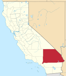
 Mountain Pass Location within the state of California | |
| Coordinates: 35°28′13″N 115°32′42″W | |
| Country | United States |
| State | California |
| County | San Bernardino |
| Elevation | 4,728 ft (1,441 m) |
| Time zone | UTC-8 (Pacific (PST)) |
| • Summer (DST) | UTC-7 (PDT) |
| ZIP Codes | 92366 |
| Area code(s) | 760 |
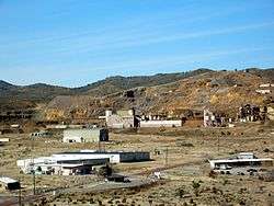
The most prominent feature of the town, and its reason for existence, is the Mountain Pass rare earth mine, an open pit mine for rare-earth elements. The mine and its associated processing facilities are owned by MP Mine Operations LLC, which purchased the assets out of bankruptcy on July 10, 2017.
Climate
| Climate data for Mountain Pass, California. (Elevation 4,740 ft) | |||||||||||||
|---|---|---|---|---|---|---|---|---|---|---|---|---|---|
| Month | Jan | Feb | Mar | Apr | May | Jun | Jul | Aug | Sep | Oct | Nov | Dec | Year |
| Record high °F (°C) | 71 (22) |
76 (24) |
81 (27) |
90 (32) |
104 (40) |
109 (43) |
110 (43) |
109 (43) |
102 (39) |
96 (36) |
89 (32) |
70 (21) |
110 (43) |
| Average high °F (°C) | 50.4 (10.2) |
53.7 (12.1) |
59.0 (15.0) |
66.4 (19.1) |
76.3 (24.6) |
87.0 (30.6) |
92.8 (33.8) |
89.9 (32.2) |
83.9 (28.8) |
72.4 (22.4) |
58.9 (14.9) |
51.1 (10.6) |
70.2 (21.2) |
| Average low °F (°C) | 29.5 (−1.4) |
32.4 (0.2) |
35.8 (2.1) |
41.0 (5.0) |
49.8 (9.9) |
59.2 (15.1) |
66.5 (19.2) |
64.5 (18.1) |
56.6 (13.7) |
46.3 (7.9) |
36.2 (2.3) |
30.2 (−1.0) |
45.7 (7.6) |
| Record low °F (°C) | 3 (−16) |
6 (−14) |
12 (−11) |
19 (−7) |
28 (−2) |
36 (2) |
42 (6) |
44 (7) |
33 (1) |
21 (−6) |
10 (−12) |
−2 (−19) |
−2 (−19) |
| Average precipitation inches (mm) | 0.92 (23) |
0.89 (23) |
0.89 (23) |
0.48 (12) |
0.27 (6.9) |
0.20 (5.1) |
1.04 (26) |
1.23 (31) |
0.59 (15) |
0.54 (14) |
0.68 (17) |
0.63 (16) |
8.36 (212) |
| Average snowfall inches (cm) | 2.7 (6.9) |
1.8 (4.6) |
1.4 (3.6) |
0.5 (1.3) |
0.2 (0.51) |
0 (0) |
0 (0) |
0 (0) |
0 (0) |
0.1 (0.25) |
1.1 (2.8) |
1.5 (3.8) |
9.3 (24) |
| Source: The Western Regional Climate Center[3] | |||||||||||||
References
- "Mountain Pass, California CA, profile (San Bernardino County)". ePodunk. 2008. Retrieved 2009-03-04.
- Population and elevation according to city limit sign on I-15 northbound.
- "Seasonal Temperature and Precipitation Information". Western Regional Climate Center. Retrieved March 29, 2013.
This article is issued from Wikipedia. The text is licensed under Creative Commons - Attribution - Sharealike. Additional terms may apply for the media files.