Loma Linda, California
Loma Linda (Spanish for '"beautiful hill"')[7] is a city in San Bernardino County, California, United States, that was incorporated in 1970.[7] The population was 23,261 at the 2010 census, up from 18,681 at the 2000 census.[8] The central area of the city was originally known as Mound City; its eastern half was originally the unincorporated community of Bryn Mawr.[7]
City of Loma Linda | |
|---|---|
City | |
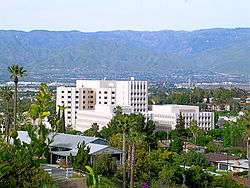 A view of Loma Linda University Medical Center, with the city surrounding it | |
| Motto(s): Serving Man | |
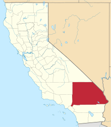
 Location of Loma Linda in San Bernardino County, California. | |
 City of Loma Linda Location in the United States | |
| Coordinates: 34°2′54″N 117°15′2″W | |
| Country | |
| State | |
| County | San Bernardino |
| Incorporated | September 29, 1970[1] |
| Government | |
| • Type | Council–manager |
| • City council[2] | Mayor Phill Dupper Mayor pro tempore: Ron Dailey Councilmember: Rhodes Rigsby John Lenart Bhavin Jindal |
| Area | |
| • Total | 7.55 sq mi (19.55 km2) |
| • Land | 7.55 sq mi (19.55 km2) |
| • Water | 0.00 sq mi (0.00 km2) 0.01% |
| Elevation | 1,165 ft (355 m) |
| Population | |
| • Total | 23,261 |
| • Estimate (2019)[6] | 24,482 |
| • Density | 3,229.40/sq mi (1,247.16/km2) |
| Time zone | UTC−8 (Pacific) |
| • Summer (DST) | UTC−7 (PDT) |
| ZIP Codes | 92350, 92354, 92357 |
| Area code | 909 |
| FIPS code | 06-42370 |
| GNIS feature IDs | 1660935, 2410857 |
| Website | www |
History
In the late 1800s, Loma Linda began as a development of tourist halls called Mound City, as encouraged by railroad companies. In the early 1800s, shops and cottages were built, but the project would later fail. During the late 1890s, a group of businessmen and physicians from Los Angeles bought the hotel and reopened it as a convalescent home and health resort. They called it Loma Linda, meaning “Beautiful Hill” in Spanish.[9] The city was incorporated in 1970.
In 1969, San Timoteo Creek overflowed its banks, inundating two-thirds of Loma Linda. Many of the bridges over the creek washed away, and Loma Linda Academy was completely flooded.[10][11][12] In 2010, the creek again flooded parts of Loma Linda.[12]
Loma Linda is twinned with Manipal, India, and Libertador San Martin, Argentina, as its sister cities.[13]
Geography
Loma Linda is located in southwestern San Bernardino County and is considered part of the Inland Empire. It is bordered on the north by San Bernardino, on the east by Redlands, on the west by Colton, and on the south by Riverside County. An area of unincorporated territory in Riverside County separates Loma Linda from the city of Moreno Valley to the south. The remnants of Bryn Mawr, an unincorporated community formerly located between Loma Linda and Redlands, was annexed by the City in 2008.
The city is in the southern San Bernardino Valley. The southern third of the city is known as the South Hills; this rugged and hilly area at the northwestern end of The Badlands is a city-owned open space reserve protected by a local initiative.[14] San Timoteo Creek flows from southeast to northwest through the city.
According to the United States Census Bureau, the city has a total area of 7.5 square miles (19 km2), 99.99% of it land.
Water contamination and air pollution
Ground water near Loma Linda is contaminated by a plume of the chemical perchlorate which was used in the manufacturing of solid rocket fuel. Also, this chemical was formerly (decades ago and in very small amounts) prescribed by physicians to control the overactive thyroid glands of certain patients. Attempts to quantify the effects of low-level exposure to perchlorate have met with resistance from environmental (and other) activists. A nearby plant operated by Lockheed Aerospace has been implicated in the improper disposal of the rocket fuel ingredient, which leached into the ground water northeast of Loma Linda. Loma Linda's municipal water supply, nevertheless, has been unaffected by the plume, primarily because Lockheed Martin installed a $19 million treatment plant in 2010 to remove both perchlorate and trichloroethylene from water after pumping it from the aquifer.[15]
Demographics
| Historical population | |||
|---|---|---|---|
| Census | Pop. | %± | |
| 1970 | 9,797 | — | |
| 1980 | 10,694 | 9.2% | |
| 1990 | 17,400 | 62.7% | |
| 2000 | 18,681 | 7.4% | |
| 2010 | 23,261 | 24.5% | |
| Est. 2019 | 24,482 | [6] | 5.2% |
| U.S. Decennial Census[16] | |||
2010
At the 2010 census Loma Linda had a population of 23,261. The population density was 3,094.3 people per square mile (1,194.7/km²). The racial makeup of Loma Linda was 47.8% White (11,122 people; 37.0% Non-Hispanic White);[17] 8.7% African American (2,032 people); 0.4% Native American (97 people); 28.3% Asian (6,589 people); 0.7% Pacific Islander (154 people); 8.7% from other races (2,022 people); and 5.4% from two or more races (1,245 people). Hispanic or Latino of any race were 5,171 people (22.2%).[18]
The census reported that 22,457 people (96.5% of the population) lived in households, 562 (2.4%) lived in non-institutionalized group quarters, and 242 (1.0%) were institutionalized.
There were 8,764 households, 2,650 (30.2%) had children under the age of 18 living in them, 3,832 (43.7%) were opposite-sex married couples living together, 1,190 (13.6%) had a female householder with no husband present, 461 (5.3%) had a male householder with no wife present. There were 351 (4.0%) unmarried opposite-sex partnerships, and 46 (0.5%) same-sex married couples or partnerships, while 2,453 households (28.0%) were one person and 837 (9.6%) had someone living alone who was 65 or older. The average household size was 2.56. There were 5,483 families (62.6% of households); the average family size was 3.18.
The age distribution was 4,859 people (20.9%) under the age of 18, 2,642 people (11.4%) aged 18 to 24, 7,463 people (32.1%) aged 25 to 44, 5,056 people (21.7%) aged 45 to 64, and 3,241 people (13.9%) who were 65 or older. The median age was 33.2 years. For every 100 females, there were 88.0 males. For every 100 females age 18 and over, there were 83.9 males.
There were 9,649 housing units at an average density of 1,283.6 per square mile, of the occupied units 3,432 (39.2%) were owner-occupied and 5,332 (60.8%) were rented.The homeowner vacancy rate was 2.5%; the rental vacancy rate was 9.9%. 9,496 people (40.8% of the population) lived in owner-occupied housing units and 12,961 people (55.7%) lived in rental housing units.
2000
At the 2000 census there were 18,681 people in 7,536 households, including 4,498 families, in the city. The population density was 2,541.7 people per square mile (981.3/km2). There were 8,084 housing units at an average density of 1,099.9 per square mile (424.7/km2). The racial makeup of the city was 54.2% White, 7.2% African American, 0.5% Native American, 24.4% Asian, 0.2% Pacific Islander, 7.5% from other races, and 6.1% from two or more races. Hispanic or Latino of any race were 16.3%.[8]
Of the 7,536 households 27.1% had children under the age of 18 living with them, 43.7% were married couples living together, 12.0% had a female householder with no husband present, and 40.3% were non-families. Of all households 31.2% were one person and 10.5% were one person aged 65 or older. The average household size was 2.4 and the average family size was 3.1.
The age distribution was 21.9% under the age of 18, 10.2% from 18 to 24, 33.2% from 25 to 44, 19.2% from 45 to 64, and 15.4% 65 or older. The median age was 34 years. For every 100 females, there were 86.4 males. For every 100 females age 18 and over, there were 82.2 males.
The median household income was $38,204 and the median family income was $45,774. Males had a median income of $36,086 versus $35,096 for females. The per capita income for the city was $20,189. About 12.9% of families and 15.1% of the population were below the poverty line, including 18.6% of those under age 18 and 5.2% of those age 65 or over. Whether or not these poverty statistics include unemployed full-time students is not known.
Government
Loma Linda uses the council-manager form of government, and the City Council is composed of Mayor Rhodes Rigsby, Mayor, Phill Dupper, Ovidiu Popescu, Ron Dailey, and pro tempore John Lenart.[2]
Police Services are done by the San Bernardino County Sheriff's Office [19]
State and federal representation
In the California State Legislature, Loma Linda is in the 23rd Senate District, represented by Republican Mike Morrell, and in the 40th Assembly District, represented by Democrat James Ramos.[20]
In the United States House of Representatives, Loma Linda is in California's 31st congressional district, represented by Democrat Pete Aguilar.[21]
Education

The city of Loma Linda forms part of the Redlands Unified School District, with Bryn Mawr Elementary School being situated within Loma Linda city limits. However, the western edge of the city is served by the Colton Unified School District. Also located in the city are Loma Linda Academy, a K-12 school, and Loma Linda University (LLU), a health-sciences higher-learning institution, both run by the Seventh-day Adventist Church.[22] Notable firsts at Loma Linda University's medical center include the first baboon-to-human heart transplant and the first split-brain surgery.
Longevity
Residents in Loma Linda have one of the highest rates of longevity in the United States.[23][24] Writer Dan Buettner has labeled Loma Linda a Blue Zone, an area where the longevity is appreciably higher than the national average and a substantial proportion of the population lives past 100 years. Buettner's 2008 book, The Blue Zones: Lessons for Living Longer From the People Who've Lived the Longest, attributes Loma Linda's longevity rate to Adventist cultural health and diet practices.[25] The city strictly controls the sale of alcohol and has banned public smoking. The church-owned grocery store does not sell meat.[23][26][27]
Notable people
- Baby Fae, first infant xenotransplant subject
- Brent Mayne, former catcher for the Kansas City Royals and San Francisco Giants.
- Matthew Modine, actor best known for his role in Full Metal Jacket
- Don Vesco, motorcycle racer in Motorsports Hall of Fame of America
- Ellsworth Wareham, centenarian former surgeon and World War II veteran.[28]
In popular culture
Loma Linda University Medical Center is featured in Venom ER, an Animal Planet program focusing on snakebite treatment at the hospital.[29]
References
- "California Cities by Incorporation Date". California Association of Local Agency Formation Commissions. Archived from the original (Word) on November 3, 2014. Retrieved August 25, 2014.
- "Boards & Commissions:City Council". Loma Linda, California: City of Loma Linda, California. Archived from the original on February 6, 2015. Retrieved January 23, 2015.
- "2016 U.S. Gazetteer Files". United States Census Bureau. Retrieved July 19, 2017.
- "Loma Linda". Geographic Names Information System. United States Geological Survey. Retrieved October 12, 2014.
- "Loma Linda (city) QuickFacts". United States Census Bureau. Archived from the original on March 27, 2015. Retrieved March 20, 2015.
- "Population and Housing Unit Estimates". Retrieved May 21, 2020.
- "About Us". Loma Linda, California: The City of Loma Linda, California. Archived from the original on June 26, 2011. Retrieved January 29, 2010.
- "U.S. Census website". United States Census Bureau. Retrieved January 31, 2008.
- "City of Loma Linda ~ Our City: About Us". Lomalinda-ca.gov. September 23, 1910. Retrieved September 26, 2018.
- "Recent rains bring of flood of memories". Redlandsdailyfacts.com. February 23, 1992. Retrieved June 23, 2017.
- "Archived copy" (PDF). Archived from the original (PDF) on March 4, 2016. Retrieved March 8, 2016.CS1 maint: archived copy as title (link)
- "Quakes Not the Only Concern Locals Face, Says Seismologist - Redlands, CA Patch". Patch.com. January 24, 2012. Retrieved June 23, 2017.
- "Sister Cities". The City of Loma Linda, California. lomalinda-ca.gov. Archived from the original on October 29, 2013. Retrieved July 29, 2013.
- "Loma Linda General Plan : Conservation and Open Space Element" (PDF). Lomalinda-ca.gov. Archived from the original (PDF) on December 11, 2015. Retrieved June 23, 2017.
- "ATSDR - Public Health Assessments & Health Consultations - California". Atsdr.cdc.gov. Retrieved June 23, 2017.
- "Census of Population and Housing". Census.gov. Retrieved June 4, 2015.
- "Loma Linda (city) QuickFacts from the US Census Bureau". census.gov. Archived from the original on March 27, 2015. Retrieved December 25, 2013.
- "2010 Census Interactive Population Search: CA - Loma Linda city". U.S. Census Bureau. Archived from the original on July 15, 2014. Retrieved July 12, 2014.
- http://www.lomalinda-ca.gov/services/police_department
- "Statewide Database". UC Regents. Archived from the original on February 1, 2015. Retrieved December 8, 2014.
- "California's 31st Congressional District - Representatives & District Map". Civic Impulse, LLC.
- "CITY OF LOMA LINDA : GENERAL PLAN" (PDF). Lomalinda-ca.gov. Archived from the original (PDF) on December 22, 2015. Retrieved June 23, 2017.
- Emily Esfahani Smith (February 4, 2013). "The Lovely Hill: Where People Live Longer and Happier". The Atlantic.
- Bowes, Peter (December 8, 2014). "Loma Linda: The secret to a long healthy life?". BBC News Magazine. Retrieved September 19, 2016.
Studies have shown that people here live up to 10 years longer than most Americans and enjoy better health in their golden years.
The reason for this extraordinary longevity could be rooted in their faith. Seventh-day Adventists make up about half of the approximately 24,000 people who live here. - Buettner, Dan (2008). The Blue Zones: Lessons for Living Longer from the People Who've Lived the Longest. The Blue Zones Series (reprint ed.). National Geographic Society (published 2010). ISBN 9781426207556. Retrieved August 14, 2019.
- Medina, Jennifer (December 11, 2011). "Fast-Food Outlet Stirs Concerns in a Mecca of Healthy Living". The New York Times. Retrieved January 20, 2015.
- "Longevity, The Secrets of Long Life - National Geographic Magazine". nationalgeographic.com.
- Carstensen, Melinda (December 16, 2014). "100-year-old surgeon, WWII vet who retired at age 95 shares secrets to longevity". Fox News. Retrieved January 20, 2015.
- Santschi, Darrell (October 27, 2009). "Loma Linda University Medical Center celebrates 100 years". The Press-Enterprise. Riverside, California. Retrieved January 29, 2010.
External links
| Wikimedia Commons has media related to Loma Linda, California. |
Places adjacent to Loma Linda, California | |
|---|---|
| Authority control |
|
|---|