Yucaipa, California
Yucaipa (/juːˈkaɪpə/ yoo-KY-pə) is a city located 10 miles (16 km) east of San Bernardino, in San Bernardino County, California, United States. The population was 51,367 at the 2010 census, up from 41,207 at the 2000 census. According to San Bernardino County, the population in 2019 is 53,921.
Yucaipa, California | |
|---|---|
City | |
| City of Yucaipa | |
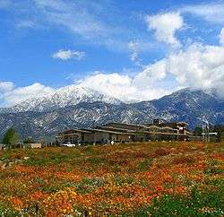 Yucaipa City Hall, with San Bernardino Peak in the background | |
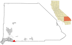 Location in San Bernardino County and the state of California | |
 Yucaipa Location in the United States  Yucaipa Yucaipa (California)  Yucaipa Yucaipa (the United States) | |
| Coordinates: 34°02′01″N 117°02′35″W | |
| Country | |
| State | |
| County | San Bernardino |
| Incorporated | November 27, 1989[1] |
| Government | |
| • Type | Council-Manager |
| • Mayor | David Avila[2] |
| Area | |
| • Total | 28.39 sq mi (73.53 km2) |
| • Land | 28.39 sq mi (73.53 km2) |
| • Water | 0.00 sq mi (0.00 km2) 0.02% |
| Elevation | 2,618 ft (798 m) |
| Population (2010) | |
| • Total | 51,367 |
| • Estimate (2019)[4] | 53,921 |
| • Density | 1,877.67/sq mi (724.98/km2) |
| Time zone | UTC-8 (PST) |
| • Summer (DST) | UTC-7 (PDT) |
| ZIP code | 92399 |
| Area code(s) | 909 |
| FIPS code | 06-87042 |
| GNIS feature ID | 1652818 |
| Website | yucaipa |
Yucaipa has the distinction of being the former longtime home to a large population of Serrano Indians and was also known for being the home base of what is now Stater Bros. Markets (founded in 1936, and now headquartered in San Bernardino).
Geography
Yucaipa City is located in the southwestern United States, in southeastern California, approximately 72 miles (116 km) east of Los Angeles. The city is approximately 2,600 ft (790 m) above sea level.
According to the United States Census Bureau, the city has a total area of 27.8 square miles (72 km2), with 0.04 percent being water.
Parks
Yucaipa is home to Yucaipa Regional Park, Flag Hill Veterans Memorial Park, Seventh Street Park, "I" Street Park, and Wildwood Park. Recently added was the Yucaipa Community Park, the Bryant Glen Sports Complex, the Rick McCowan Regional Soccer Complex, as well as the newly established Wildwood Canyon State Park.
Climate
According to the Köppen Climate Classification system, Yucaipa has a Mediterranean climate, abbreviated "Csa" on climate maps.[5]
| Climate data for Yucaipa (2,630 feet above sea level) | |||||||||||||
|---|---|---|---|---|---|---|---|---|---|---|---|---|---|
| Month | Jan | Feb | Mar | Apr | May | Jun | Jul | Aug | Sep | Oct | Nov | Dec | Year |
| Record high °F (°C) | 83 (28) |
88 (31) |
95 (35) |
100 (38) |
106 (41) |
109 (43) |
114 (46) |
113 (45) |
112 (44) |
106 (41) |
94 (34) |
86 (30) |
114 (46) |
| Average high °F (°C) | 63 (17) |
65 (18) |
69 (21) |
74 (23) |
81 (27) |
89 (32) |
96 (36) |
97 (36) |
92 (33) |
81 (27) |
71 (22) |
63 (17) |
78 (26) |
| Daily mean °F (°C) | 52.0 (11.1) |
53.0 (11.7) |
55.5 (13.1) |
59.5 (15.3) |
65.5 (18.6) |
71.5 (21.9) |
78.0 (25.6) |
79.0 (26.1) |
74.5 (23.6) |
65.5 (18.6) |
57.5 (14.2) |
51.5 (10.8) |
63.6 (17.6) |
| Average low °F (°C) | 41 (5) |
41 (5) |
42 (6) |
45 (7) |
50 (10) |
54 (12) |
60 (16) |
61 (16) |
57 (14) |
50 (10) |
44 (7) |
40 (4) |
49 (9) |
| Record low °F (°C) | 11 (−12) |
19 (−7) |
21 (−6) |
25 (−4) |
31 (−1) |
35 (2) |
42 (6) |
38 (3) |
37 (3) |
29 (−2) |
20 (−7) |
20 (−7) |
11 (−12) |
| Average precipitation inches (mm) | 3.91 (99) |
4.45 (113) |
3.09 (78) |
1.19 (30) |
0.65 (17) |
0.17 (4.3) |
0.35 (8.9) |
0.26 (6.6) |
0.49 (12) |
1.03 (26) |
1.57 (40) |
2.33 (59) |
19.49 (493.8) |
| Source: Weather Channel[6] | |||||||||||||
Demographics
| Historical population | |||
|---|---|---|---|
| Census | Pop. | %± | |
| 1970 | 19,284 | — | |
| 1980 | 23,345 | 21.1% | |
| 1990 | 32,824 | 40.6% | |
| 2000 | 41,207 | 25.5% | |
| 2010 | 51,367 | 24.7% | |
| Est. 2019 | 53,921 | [4] | 5.0% |
| U.S. Decennial Census[7] | |||
2010
At the 2010 census Yucaipa had a population of 51,367. The population density was 1,841.5 people per square mile (711.0/km²). The racial makeup of Yucaipa was 40,824 (79.5%) White (65.9% Non-Hispanic White),[8] 837 (1.6%) African American, 485 (0.9%) Native American, 1,431 (2.8%) Asian, 74 (0.1%) Pacific Islander, 5,589 (10.9%) from other races, and 2,127 (4.1%) from two or more races. Hispanic or Latino of any race were 13,943 persons (27.1%).[9]
The census reported that 50,813 people (98.9% of the population) lived in households, 227 (0.4%) lived in non-institutionalized group quarters, and 327 (0.6%) were institutionalized.
There were 18,231 households, 6,996 (38.4%) had children under the age of 18 living in them, 9,842 (54.0%) were opposite-sex married couples living together, 2,231 (12.2%) had a female householder with no husband present, 1,026 (5.6%) had a male householder with no wife present. There were 1,061 (5.8%) unmarried opposite-sex partnerships, and 114 (0.6%) same-sex married couples or partnerships. 4,198 households (23.0%) were one person and 1,970 (10.8%) had someone living alone who was 65 or older. The average household size was 2.79. There were 13,099 families (71.9% of households); the average family size was 3.29.
The age distribution was 13,444 people (26.2%) under the age of 18, 4,489 people (8.7%) aged 18 to 24, 12,536 people (24.4%) aged 25 to 44, 14,064 people (27.4%) aged 45 to 64, and 6,834 people (13.3%) who were 65 or older. The median age was 37.8 years. For every 100 females, there were 96.8 males. For every 100 females age 18 and over, there were 92.5 males.
There were 19,642 housing units at an average density of 704.2 per square mile, of the occupied units 13,503 (74.1%) were owner-occupied and 4,728 (25.9%) were rented.The homeowner vacancy rate was 3.0%; the rental vacancy rate was 9.0%. 37,165 people (72.4% of the population) lived in owner-occupied housing units and 13,648 people (26.6%) lived in rental housing units.
2000
Since the city incorporated in 1989, it has experienced a significant level of growth. At the 2000 census Yucaipa had 41,207 residents, 15,193 households, and 10,680 families. The population density was 1,483.4 inhabitants per square mile (572.7/km²). There were 16,112 housing units at an average density of 580.0 per square mile (223.9/km²). The racial makeup was 85.2% White, 0.9% African American, 1.1% Native American, 1.2% Asian, 0.1% Pacific Islander, 8.0% from other races, and 3.5% from two or more races. Hispanics or Latinos constitute 18.4%.[10]
Of the 15,193 households 35.4% had children under the age of 18; 54.2% were married couples; 11.6% had a female householder; and 29.7% were non-families. 25.3% of households were one person and 13.4% of those were 65 or older. The average household size was 2.7 and the average family size was 3.2.
The age distribution was 28.5% under the age of 18, 7.6% from 18 to 24, 27.2% from 25 to 44, 21.2% from 45 to 64, and 15.5% 65 or older. The median age was 37 years. For every 100 females, there were 93.5 males. For every 100 females age 18 and over, there were 88.4 males.
The median household income was $39,144 and the median family income was $48,683. Males had a median income of $40,480 versus $25,957 for females. The per capita income for the city was $18,949. About 8.8% of families and 11.2% of the population were below the poverty line, including 13.2% of those under age 18 and 7.2% of those age 65 or over.
History
| Yucaipa Rancheria | |
|---|---|
| Location | Yucaipa, California |
| Built | 1842 |
| Designated | September 11, 1957 |
| Reference no. | 620 |
Prior to the Spanish conquest of the Americas and the arrival of European settlers from Mexico, the land of the Yucaipa Valley was occupied by the Serrano Indians for possibly 1,000 years.
Yucaipa Rancheria
Yucaipa Valley supported a large population of Serrano Indians. The fertile valley was watered by springs and creeks running out of the San Bernardino Mountains. The Serrano lived in this location most of the year, but would make excursions into the mountains to gather acorns and other food items during their harvest season. The Serrano name for the area was Yucaipat which meant "green valley." The Rancheria is marked by California Historical Landmark #620.[11]
Yucaipa Adobe
.jpg)
| Yucaipa Adobe | |
|---|---|
| Location | Yucaipa, California |
| Built | 1842 |
| Designated | September 11, 1957 |
| Reference no. | 528 |
Near the Rancheria is the Yucaipa Adobe that is believed to be the oldest house in San Bernardino County. Diego Sepúlveda, nephew of Antonio María Lugo, built the Adobe in 1842 on land that was part of the Rancho San Bernardino granted in 1842 to the Lugos. It had formerly been land controlled by San Gabriel Mission. The Rancho suffered losses of cattle and horses from raids by Native Americans coming through Cajon Pass and Banning Pass from the deserts. Eventually, they sold the Rancho to Mormon settlers in September 1851. The Adobe's later owners included John Brown, Sr., James W. Waters, and the Dunlap family; it was acquired by San Bernardino County in 1955. The site is marked by California Historical Landmark #528.[11]
The nearby Oak Glen area is best known for its apple orchards, some of which are operated by the direct descendants of the original founders (the Parrish, Wilshire, Rivers, and Law families). The Parrish Pioneer Ranch and orchard were founded by Enoch Parrish in 1876, with the other families coming into the area later.
2005 earthquake
At 1:53 p.m. on June 16, 2005, Yucaipa experienced a 4.9 Mw earthquake that was centered four miles (6 km) north of the center of town. It had a maximum Mercalli intensity of VI (Strong) and was felt from downtown Los Angeles to some areas of San Diego. Three people were injured.[12]
2012 uptown revitalization
In a controversial effort to reinvigorate the struggling uptown Yucaipa area, the city took on multiple uptown boulevard improvements:
Uptown Yucaipa Boulevard Improvements, 2nd Street to Bryant Street (Phase 2B)
This phase of the project, funded by Redevelopment Agency (1998, 2004 and 2010/11) Tax Allocation Bond funds and Pavement Management Program funds completed street, drainage, hardscape, parallel on-street parking and reverse angle parking improvements on Yucaipa Boulevard between Bryant Street and 2nd Street. The project also included intersection improvements, replacing the existing traffic signals at the intersections of Yucaipa Boulevard at 2nd Street and California Street with roundabouts, associated hardscape and landscape features. Pedestrian improvements, including sidewalk, ADA curb ramps, crosswalks, street light foundations and associated signing and striping were also incorporated into the project.
Uptown Yucaipa Boulevard Improvements, 2nd Street to Bryant Street (Phase 2C & 2D)
This project, ultimately funded the same as Phase 2B above, provided decorative street light pole fixtures fitted with banners, speakers, video cameras (at limited locations), receptacles, and hanging baskets, lighted bollards, and the infrastructure, such as conduit, wiring and power source pedestals, required to support the project. Phase 2D provided landscaping in the planters including trees (with accent lighting), shrubs and wood chips along with the necessary irrigation, wiring, water meter and control systems necessary to support the landscaping and outdoor speakers for the sound system.
Uptown Decorative Metal Archway
This project was also funded by Redevelopment Agency (1998, 2004 and 2010/11) Tax Allocation Bond funds and Pavement Management Program funds and will install the Decorative Metal Archway immediately west of the 2nd Street Roundabout on Yucaipa Boulevard.
Uptown Decorative Metal Fence Fabrication and Installation
This phase of the Uptown Streetscape Project was also funded by Redevelopment Agency (1998, 2004 and 2010/11) Tax Allocation Bond funds and Pavement Management Program funds and installed a decorative metal fence in the roundabout areas at 2nd Street and California Street and Yucaipa Boulevard.
2019 Uptown Revitalization
Performing Arts Center
In 2016, Yucaipa broke ground on a multi-purpose performing arts center on the corner of Acacia Avenue and California Street. Sitting on 2.7 acres in the heart of uptown, the 16,200 sq. ft. venue will host a variety of events including a community theater, open-air concerts, dance, and other arts-related events.
Government
In the California State Legislature, Yucaipa is in the 23rd Senate District, represented by Republican Mike Morrell, and in the 42nd Assembly District, represented by ? Chad Mayes.[13]
In the United States House of Representatives, Yucaipa is in California's 8th congressional district, represented by Republican Paul Cook.[14]
From November 1999, Richard (Dick) D. Riddell was the longest-serving mayor (and the oldest, at age 88) in Yucaipa's history. In November 2012, at the request of newly sworn councilman Bobby Duncan, Denise Hoyt was named the new Mayor.
Education in Yucaipa
The Yucaipa-Calimesa Joint Unified School District serves both cities, with the following schools:
- Elementary (K–5): Dunlap, Chapman Heights, Calimesa, Yucaipa (now closed), Meadow Creek (now closed), Ridgeview, Valley, Wildwood, Inland Leaders Charter School, Competitive Edge Charter Academy
- Middle school (6–8): Park View Middle School, Mesa View Middle School (in Calimesa), Competitive Edge Charter Academy, Inland Leaders Charter School
- High school: Yucaipa High School (9-12), Green Valley High School (10-12)
The San Bernardino Community College District serves Yucaipa and the Inland Empire at Crafton Hills College, located in the city.[15]
Public safety
The San Bernardino County Sheriff's Department serves Yucaipa—including the nearby unincorporated towns of Mentone, Oak Glen, Forest Falls, Angeleus Oaks, and Mountain Home Village—from its regional station at 34282 Yucaipa Boulevard(a much bigger replacement opened on July 1, 2014, next door to City Hall with a new address:34144 Yucaipa Boulevard). Since there is no official jail facility at this station, suspects are booked at either Central Jail in downtown San Bernardino or the West Valley Detention Center in Rancho Cucamonga.
Yucaipa has contracted operation of its fire department to the California Department of Forestry and Fire Protection (now known as "Cal Fire") which serves the city from three stations: the 33000 block of Yucaipa Boulevard, Bryant Street (in the "North Bench" area), and the southwest corner of Fifth Street and Wildwood Canyon Road. Cal-Fire also provides paramedic level emergency medical service while patient transport by ground is handled by a private ambulance service.
Notable people
- Susan Anton - Miss California 1969, singer and actress
- Matt Carson - professional baseball player
- Tyler Chatwood - professional baseball player for Colorado Rockies
- Matt Davidson - professional baseball player for Chicago White Sox
- Noble Johnson - actor
- Corky Miller - professional baseball player
- Lois Rodden - astrologer, author of Data News
- Mark Teahen - professional baseball player
- Taijuan Walker - professional baseball player for Arizona Diamondbacks
California Historical Landmark
Marker at the site reads:
- NO. 620 YUCAIPA RANCHERIA - Yucaipa Valley supported a large population of Serrano Indians. The fertile valley was watered by springs and creeks. The Indians called this area 'Yucaipat' which meant 'wet lands.' These Native Americans lived at this village site most of the year, with occasional excursions to the mountains to gather acorns and other food items during the harvesting season.[16]
Marker at the site reads:
- NO. 528 YUCAIPA ADOBE - Constructed in 1842 by Diego Sepúlveda, nephew of Antonio María Lugo, this is believed to be the oldest house in San Bernardino County. The land, formerly controlled by San Gabriel Mission, was part of the Rancho San Bernardino granted to the Lugos in 1842. The adobe's later owners included John Brown, Sr., James W. Waters, and the Dunlap family, it was acquired by San Bernardino County in 1955.[17]
See also
References
- "California Cities by Incorporation Date". California Association of Local Agency Formation Commissions. Archived from the original (Word) on October 17, 2013. Retrieved August 25, 2014.
- City of Yucaipa web site
- "2016 U.S. Gazetteer Files". United States Census Bureau. Retrieved Jun 28, 2017.
- "Population and Housing Unit Estimates". Retrieved May 21, 2020.
- "Yucaipa, California Köppen Climate Classification (Weatherbase)". Weatherbase. Retrieved 4 February 2016.
- "Yucaipa, CA Monthly Weather Forecast". Weather Channel. Retrieved 6 October 2017.
- "Census of Population and Housing". Census.gov. Retrieved June 4, 2015.
- "Yucaipa (city) QuickFacts from the US Census Bureau". Archived from the original on 1 September 2012. Retrieved 4 February 2016.
- "2010 Census Interactive Population Search: CA - Yucaipa city". U.S. Census Bureau. Archived from the original on July 15, 2014. Retrieved July 12, 2014.
- "U.S. Census website". United States Census Bureau. Retrieved 2008-01-31.
- "California Historical Landmark: San Bernardino County". Office of Historic Preservation. California State Parks. Retrieved 2012-10-12.
- USGS. "M4.9 - Greater Los Angeles area, California". United States Geological Survey.
- "Statewide Database". UC Regents. Archived from the original on February 1, 2015. Retrieved February 11, 2015.
- "California's 8th Congressional District - Representatives & District Map". Civic Impulse, LLC.
- "Home - Crafton Hills College". Retrieved 4 February 2016.
- californiahistoricallandmarks.com, 620
- California parks, California Historical Landmarks
External links
| Wikimedia Commons has media related to Yucaipa, California. |
- City of Yucaipa
- The website for the Yucaipa-Calimesa Joint Unified School District
- The Yucaipa Valley Chamber of Commerce

| Authority control |
|
|---|